
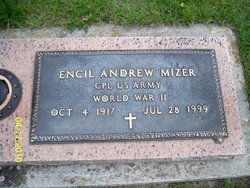
Encil Andrew Mizer
| Birth | : | 4 Oct 1917 |
| Death | : | 28 Jul 1999 |
| Burial | : | Pleasington Cemetery and Crematorium, Blackburn, Blackburn with Darwen Unitary Authority, England |
| Coordinate | : | 53.7388880, -2.5368710 |
| Description | : | Encil A. Mizer, age 81, died Wednesday, July 28, 1999. He was a retired steam engineer at The Medical College of Ohio . He was a member of the Delta American Legion Post 373, the Swamp Angels Alumni Association, and Faith Luthern Church, Swanton. He served in the U. S. Army during WW II where he was awarded a Bronze Medal. He is survived by his wife, Eileen; son, Wayne (Mary) of Toledo; daughters, Myrna (Shelby) Gibson of Napoleon and Vicki (Larry) Burke of Boston, MA; eight grandchildren and four great-grandchildren. Services will be Saturday, July 31, 1999 at 11 a. m.... Read More |
frequently asked questions (FAQ):
-
Where is Encil Andrew Mizer's memorial?
Encil Andrew Mizer's memorial is located at: Pleasington Cemetery and Crematorium, Blackburn, Blackburn with Darwen Unitary Authority, England.
-
When did Encil Andrew Mizer death?
Encil Andrew Mizer death on 28 Jul 1999 in
-
Where are the coordinates of the Encil Andrew Mizer's memorial?
Latitude: 53.7388880
Longitude: -2.5368710
Family Members:
Parent
Spouse
Siblings
Flowers:


Nearby Cemetories:
1. Pleasington Cemetery and Crematorium
Blackburn, Blackburn with Darwen Unitary Authority, England
Coordinate: 53.7388880, -2.5368710
2. Pleasington Priory
Pleasington, Blackburn with Darwen Unitary Authority, England
Coordinate: 53.7348590, -2.5433060
3. New Row Methodist Church
Blackburn with Darwen Unitary Authority, England
Coordinate: 53.7208950, -2.5023720
4. St Paul's
Blackburn, Blackburn with Darwen Unitary Authority, England
Coordinate: 53.7491222, -2.4891266
5. St. Peter's Churchyard
Blackburn, Blackburn with Darwen Unitary Authority, England
Coordinate: 53.7448110, -2.4865070
6. Holy Trinity Churchyard
Hoghton, Chorley Borough, England
Coordinate: 53.7279300, -2.5848550
7. St. Josephs Roman Catholic Churchyard
Brindle, Chorley Borough, England
Coordinate: 53.7350780, -2.5880640
8. Independent Chapel Churchyard
Blackburn, Blackburn with Darwen Unitary Authority, England
Coordinate: 53.7454960, -2.4864460
9. Wesleyan Methodist Chapel Chapelyard
Blackburn, Blackburn with Darwen Unitary Authority, England
Coordinate: 53.7464910, -2.4848380
10. Blackburn Cathedral
Blackburn, Blackburn with Darwen Unitary Authority, England
Coordinate: 53.7472960, -2.4820020
11. St. Mary's Churchyard
Mellor, Ribble Valley Borough, England
Coordinate: 53.7728600, -2.5312400
12. St Stephen Churchyard
Tockholes, Blackburn with Darwen Unitary Authority, England
Coordinate: 53.7058350, -2.5169320
13. Mellor Methodist Churchyard
Blackburn, Blackburn with Darwen Unitary Authority, England
Coordinate: 53.7742950, -2.5255060
14. Mount St Presbyterian Chapelyard
Blackburn, Blackburn with Darwen Unitary Authority, England
Coordinate: 53.7478000, -2.4775000
15. Holy Trinity Church
Blackburn with Darwen Unitary Authority, England
Coordinate: 53.7511727, -2.4747178
16. St Alban's Churchyard
Blackburn, Blackburn with Darwen Unitary Authority, England
Coordinate: 53.7530090, -2.4748540
17. St Mary's R.C. Church Cemetery
Osbaldeston, Ribble Valley Borough, England
Coordinate: 53.7816970, -2.5350240
18. St Paul's Churchyard
Withnell, Chorley Borough, England
Coordinate: 53.6970740, -2.5592150
19. St James Churchyard
Lower Darwen, Blackburn with Darwen Unitary Authority, England
Coordinate: 53.7245510, -2.4634700
20. Blackburn Cemetery
Blackburn, Blackburn with Darwen Unitary Authority, England
Coordinate: 53.7662430, -2.4726050
21. St Leonard Churchyard
Balderstone, Ribble Valley Borough, England
Coordinate: 53.7860070, -2.5609380
22. St James's Churchyard
Brindle, Chorley Borough, England
Coordinate: 53.7133333, -2.6086111
23. St. Mary's and St. John RC Churchyard, Southworth
Samlesbury, South Ribble Borough, England
Coordinate: 53.7676690, -2.6183400
24. St. Leonard the Less Churchyard
Samlesbury, South Ribble Borough, England
Coordinate: 53.7680000, -2.6237000