

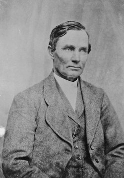
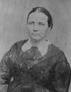
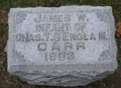
Enola May Jackson Carr
| Birth | : | 20 Oct 1864 Richvalley, Wabash County, Indiana, USA |
| Death | : | 4 Jan 1946 Peru, Miami County, Indiana, USA |
| Burial | : | Saint John's Cemetery, Lancaster, Worcester County, USA |
| Coordinate | : | 42.4328003, -71.6977997 |
| Plot | : | Sec E, lot 113, sp 3 UNMARKED |
| Description | : | OBITUARY - Plain Dealer, Wabash (IN) Enola May Carr, 81, wife of Charles T. Carr, died at 9:50 o'clock Friday evening in the home of her daughter, Mrs. Nelson Fox, 315 South Wabash street, Peru. She had been ill several months and had been bedfast for five days, her death being attributed to complications. Mrs. Carr was born Oct. 20, 1864 in Richvalley, a daughter of James and Celia (Thompson) Jackson. She was married Oct. 12, 1899, in Wabash, to Charles T. Carr, who died May 12, 1923. Mrs. Carr had been a resident of Peru 22 years, moving there from... Read More |
frequently asked questions (FAQ):
-
Where is Enola May Jackson Carr's memorial?
Enola May Jackson Carr's memorial is located at: Saint John's Cemetery, Lancaster, Worcester County, USA.
-
When did Enola May Jackson Carr death?
Enola May Jackson Carr death on 4 Jan 1946 in Peru, Miami County, Indiana, USA
-
Where are the coordinates of the Enola May Jackson Carr's memorial?
Latitude: 42.4328003
Longitude: -71.6977997
Family Members:
Parent
Spouse
Siblings

Children
Flowers:


Nearby Cemetories:
1. Saint John's Cemetery
Lancaster, Worcester County, USA
Coordinate: 42.4328003, -71.6977997
2. Woodlawn Cemetery
Clinton, Worcester County, USA
Coordinate: 42.4185982, -71.6889038
3. Middle Cemetery
Lancaster, Worcester County, USA
Coordinate: 42.4491997, -71.6757965
4. Old Settlers Burial Yard
Lancaster, Worcester County, USA
Coordinate: 42.4488754, -71.6742706
5. Thayer Cemetery
Lancaster, Worcester County, USA
Coordinate: 42.4578500, -71.7024400
6. Reservoir Pines Cemetery
Clinton, Worcester County, USA
Coordinate: 42.4084900, -71.7109700
7. Old Common Burial Ground
Lancaster, Worcester County, USA
Coordinate: 42.4426700, -71.6645300
8. Fairbank Burial Ground
Sterling, Worcester County, USA
Coordinate: 42.4152600, -71.7320000
9. Eastwood Cemetery
Lancaster, Worcester County, USA
Coordinate: 42.4417000, -71.6528015
10. Hillside Cemetery
Sterling, Worcester County, USA
Coordinate: 42.4410000, -71.7492570
11. Oak Hill Cemetery
Sterling, Worcester County, USA
Coordinate: 42.4417000, -71.7493973
12. North Village Cemetery
Lancaster, Worcester County, USA
Coordinate: 42.4724998, -71.6778030
13. Chocksett Burial Ground
Sterling, Worcester County, USA
Coordinate: 42.4377000, -71.7555400
14. West Burying Ground
Bolton, Worcester County, USA
Coordinate: 42.4488983, -71.6300964
15. West Cemetery
Sterling, Worcester County, USA
Coordinate: 42.4514100, -71.7651400
16. Cookshire Cemetery
Sterling, Worcester County, USA
Coordinate: 42.4108500, -71.7734800
17. Old Fry Burying Ground
Bolton, Worcester County, USA
Coordinate: 42.4077300, -71.6209900
18. Friends Burial Ground
Bolton, Worcester County, USA
Coordinate: 42.4133620, -71.6176710
19. North Cemetery
Berlin, Worcester County, USA
Coordinate: 42.4037000, -71.6225100
20. Old South Burying Ground
Bolton, Worcester County, USA
Coordinate: 42.4231000, -71.6096500
21. Saint Lukes Cemetery
West Boylston, Worcester County, USA
Coordinate: 42.3833008, -71.7568970
22. Old Burying Ground
Berlin, Worcester County, USA
Coordinate: 42.3811646, -71.6375351
23. Saint Benedict Center Cemetery
Harvard, Worcester County, USA
Coordinate: 42.4827900, -71.6231900
24. Legg Cemetery
Sterling, Worcester County, USA
Coordinate: 42.4070020, -71.7986150