


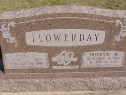
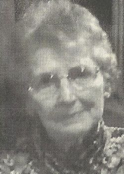
Erma F. Zillig Flowerday
| Birth | : | 28 Aug 1912 |
| Death | : | 24 Feb 2010 |
| Burial | : | Saint William Cemetery, Knottsville, Daviess County, USA |
| Coordinate | : | 37.7749050, -86.9086010 |
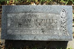
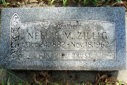
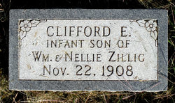
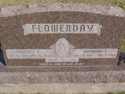
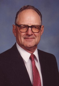
| Description | : | She was the second of seven children born to William and Nellie Maude (Francies) Zillig. Erma attended rural schools, including Leahy School. She graduated from the 8th grade, the second highest in Seward County. In 1930, she graduated from Seward High School and attended the University of Nebraska in preparation for teaching in rural schools for five years. On June 2, 1935, Erma was united in marriage to Theodore Milton Flowerday at her parent's home, east of Seward. Five children were born to this union, Janice, Marilyn Judith, Maureen and Theodore. The couple farmed in Seward County, moving to their farm... Read More |
frequently asked questions (FAQ):
-
Where is Erma F. Zillig Flowerday's memorial?
Erma F. Zillig Flowerday's memorial is located at: Saint William Cemetery, Knottsville, Daviess County, USA.
-
When did Erma F. Zillig Flowerday death?
Erma F. Zillig Flowerday death on 24 Feb 2010 in
-
Where are the coordinates of the Erma F. Zillig Flowerday's memorial?
Latitude: 37.7749050
Longitude: -86.9086010
Family Members:
Parent
Spouse
Siblings
Children
Flowers:


Nearby Cemetories:
1. Saint William Cemetery
Knottsville, Daviess County, USA
Coordinate: 37.7749050, -86.9086010
2. Saint Lawrence Cemetery
Knottsville, Daviess County, USA
Coordinate: 37.7638700, -86.8716000
3. Higdon Farm Cemetery
Knottsville, Daviess County, USA
Coordinate: 37.7846100, -86.8651900
4. Pleasant Valley Christian Church Cemetery
Knottsville, Daviess County, USA
Coordinate: 37.7682991, -86.9546967
5. Winkler Cemetery
Knottsville, Daviess County, USA
Coordinate: 37.7989006, -86.9452972
6. Mount Zion Presbyterian Church Cemetery
Knottsville, Daviess County, USA
Coordinate: 37.8006600, -86.9469600
7. Providence United Methodist Cemetery
Philpot, Daviess County, USA
Coordinate: 37.7320800, -86.9198200
8. Bell Cemetery
Spice Knob, Daviess County, USA
Coordinate: 37.8067017, -86.9578018
9. Hite and Payne Family Cemetery
Philpot, Daviess County, USA
Coordinate: 37.7511410, -86.8491940
10. Adcock-Pursell-Simpson Cemetery
Philpot, Daviess County, USA
Coordinate: 37.7323390, -86.9503300
11. Roberts Cemetery
Knottsville, Daviess County, USA
Coordinate: 37.8231010, -86.8764038
12. Gabbert Family Plot
Philpot, Daviess County, USA
Coordinate: 37.7406080, -86.9639350
13. Bethlehem United Methodist Church Cemetery
Daviess County, USA
Coordinate: 37.8274600, -86.9352000
14. Shouse Family Cemetery
Spice Knob, Daviess County, USA
Coordinate: 37.8198800, -86.9602600
15. South Hampton Church Cemetery
Owensboro, Daviess County, USA
Coordinate: 37.7813000, -86.9927300
16. Gatewood Cemetery
Daviess County, USA
Coordinate: 37.8331000, -86.8659800
17. Karn's Grove Baptist Church Cemetery
Philpot, Daviess County, USA
Coordinate: 37.7102000, -86.9390600
18. Cooper-Puckett Cemetery
Lewisport, Hancock County, USA
Coordinate: 37.8370132, -86.8701319
19. Karn Family Cemetery
Philpot, Daviess County, USA
Coordinate: 37.7097740, -86.9388123
20. Horn Cemetery
Gatewood, Daviess County, USA
Coordinate: 37.8348112, -86.8613678
21. Barker Cemetery
Gatewood, Daviess County, USA
Coordinate: 37.8343444, -86.8566807
22. Barnhill Cemetery
Philpot, Daviess County, USA
Coordinate: 37.7150650, -86.9604874
23. Pleasant Grove United Methodist Church Cemetery
Philpot, Daviess County, USA
Coordinate: 37.7457800, -86.9984500
24. Pellville Cemetery
Pellville, Hancock County, USA
Coordinate: 37.7529600, -86.8104000