
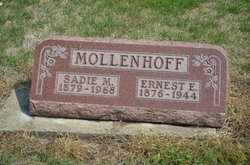
Ernest Eletus Mollenhoff
| Birth | : | 27 Feb 1876 Andover, Henry County, Illinois, USA |
| Death | : | 4 Sep 1944 Red Oak, Montgomery County, Iowa, USA |
| Burial | : | Dayton Cemetery, Dayton, Webster County, USA |
| Coordinate | : | 42.2675000, -94.0755000 |
| Plot | : | Section 4 |
| Description | : | Council Bluffs Nonpareil September 5, 1944 E.E. Mollenhoff RED OAK - Funeral services will be held at Stanton Thursday at the Mamrelund Lutheran Church for Ernest E. Mollenhoff, 68, retired business man of Stanton, who died Monday at the Red Oak hospital following a 10-day illness of heart trouble. Mr. Mollenhoff, who came to Stanton in 1900, had been in business there for 37 years. He was the present assessor, treasurer of the building committee of the Mamrelund Lutheran Church, trustee for years, and president of the school board. Mr. Mollenhoff was also the one who burnt... Read More |
frequently asked questions (FAQ):
-
Where is Ernest Eletus Mollenhoff's memorial?
Ernest Eletus Mollenhoff's memorial is located at: Dayton Cemetery, Dayton, Webster County, USA.
-
When did Ernest Eletus Mollenhoff death?
Ernest Eletus Mollenhoff death on 4 Sep 1944 in Red Oak, Montgomery County, Iowa, USA
-
Where are the coordinates of the Ernest Eletus Mollenhoff's memorial?
Latitude: 42.2675000
Longitude: -94.0755000
Family Members:
Parent

Spouse

Siblings

Flowers:


Nearby Cemetories:
1. Dayton Cemetery
Dayton, Webster County, USA
Coordinate: 42.2675000, -94.0755000
2. Christ the King Catholic Cemetery
Dayton, Webster County, USA
Coordinate: 42.2601929, -94.0727539
3. Bass Cemetery
Dayton, Webster County, USA
Coordinate: 42.2966995, -94.0149994
4. Swedish Lutheran Church Cemetery
Dayton, Webster County, USA
Coordinate: 42.2175000, -94.1065000
5. Oak Grove Cemetery
Lehigh, Webster County, USA
Coordinate: 42.3438988, -94.0475006
6. Hardin Township Cemetery
Hardin Township, Webster County, USA
Coordinate: 42.2411003, -93.9708023
7. Linn Cemetery
Pilot Mound, Boone County, USA
Coordinate: 42.2045330, -93.9970230
8. Lawn Cemetery
Boone County, USA
Coordinate: 42.1771011, -94.0867996
9. West Lawn Cemetery
Lehigh, Webster County, USA
Coordinate: 42.3616982, -94.0678024
10. McGuire Bend Cemetery
Dayton, Webster County, USA
Coordinate: 42.3410000, -93.9880000
11. Runyan Cemetery
Pilot Mound, Boone County, USA
Coordinate: 42.1749992, -94.0015030
12. Pilot Mound Cemetery
Pilot Mound, Boone County, USA
Coordinate: 42.1636200, -94.0282600
13. Vegors Cemetery
Webster County, USA
Coordinate: 42.3177986, -93.9421997
14. Lost Grove Cemetery
Harcourt, Webster County, USA
Coordinate: 42.2583008, -94.2331009
15. Hooks Point Cemetery
Hamilton County, USA
Coordinate: 42.2944530, -93.9199090
16. Oakwood Cemetery
Stratford, Hamilton County, USA
Coordinate: 42.2942009, -93.9182968
17. Hartman Cemetery
Lehigh, Webster County, USA
Coordinate: 42.3666397, -93.9835627
18. White Cemetery
Boone County, USA
Coordinate: 42.1777992, -93.9636002
19. Border Plains Cemetery
Border Plains, Webster County, USA
Coordinate: 42.3917000, -94.0448000
20. Ober and Scott Cemetery
Duncombe, Webster County, USA
Coordinate: 42.3841390, -93.9982856
21. Union Cemetery
Boxholm, Boone County, USA
Coordinate: 42.1369019, -94.0852966
22. Renner Cemetery
Boone County, USA
Coordinate: 42.1380420, -94.1256570
23. Otho Cemetery
Otho, Webster County, USA
Coordinate: 42.4025002, -94.1153030
24. Schlicht Cemetery
Fraser, Boone County, USA
Coordinate: 42.1444200, -93.9780100