
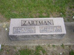
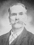
Ernest Farnsworth Zartman
| Birth | : | 3 Jun 1890 Miami County, Indiana, USA |
| Death | : | 8 Dec 1931 Fulton County, Indiana, USA |
| Burial | : | Hurley Cemetery, Hurley, Grant County, USA |
| Coordinate | : | 32.6885986, -108.1363983 |
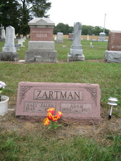
| Description | : | OBITUARY The Rochester (IN) Sentinel Tuesday, December 8, 1931 Ernest ZARTMAN, aged 41, died at his farm home five and one-half miles northeast of this city at six o'clock this morning from pneumonia. Zartman had been in ill health for the past year. He had been ill with pneumona about two weeks. The deceased was born on a farm in Miami county on June 3, 1890. His parents were Adam and Mary ZARTMAN. He has resided in this county for the past 20 years. Survivors are his widow; mother; two daughters, Alice [ZARTMAN] and Mary [ZARTMAN],... Read More |
frequently asked questions (FAQ):
-
Where is Ernest Farnsworth Zartman's memorial?
Ernest Farnsworth Zartman's memorial is located at: Hurley Cemetery, Hurley, Grant County, USA.
-
When did Ernest Farnsworth Zartman death?
Ernest Farnsworth Zartman death on 8 Dec 1931 in Fulton County, Indiana, USA
-
Where are the coordinates of the Ernest Farnsworth Zartman's memorial?
Latitude: 32.6885986
Longitude: -108.1363983
Family Members:
Parent
Spouse

Siblings
Children
Flowers:


Nearby Cemetories:
1. Hurley Cemetery
Hurley, Grant County, USA
Coordinate: 32.6885986, -108.1363983
2. Bayard Cemetery
Bayard, Grant County, USA
Coordinate: 32.7403620, -108.1326270
3. Santa Clara Cemetery
Central, Grant County, USA
Coordinate: 32.7701920, -108.1530590
4. Vanadium Cemetery
Vanadium, Grant County, USA
Coordinate: 32.7820000, -108.1100000
5. Fort Bayard Memorial Cemetery
Fort Bayard, Grant County, USA
Coordinate: 32.7907000, -108.1565000
6. Fort Bayard National Cemetery
Fort Bayard, Grant County, USA
Coordinate: 32.7989006, -108.1541977
7. Hanover Cemetery
Hanover, Grant County, USA
Coordinate: 32.8063000, -108.0893000
8. Memory Lane Cemetery
Silver City, Grant County, USA
Coordinate: 32.7830000, -108.2570000
9. Saint Vincent de Paul Catholic Cemetery
Silver City, Grant County, USA
Coordinate: 32.7572861, -108.2812361
10. Masonic Cemetery
Silver City, Grant County, USA
Coordinate: 32.7572972, -108.2812361
11. Santa Rita Cemetery #4
Santa Rita, Grant County, USA
Coordinate: 32.8137200, -108.0576200
12. Santa Rita #4
Santa Rita (Noriega y Anexo), Santa Bárbara Municipality, Mexico
Coordinate: 32.8136425, -108.0571579
13. Pine Cienega Cemetery
Grant County, USA
Coordinate: 32.6226050, -108.3039090
14. Fierro Cemetery
Fierro, Grant County, USA
Coordinate: 32.8436012, -108.0755997
15. Georgetown Cemetery
Silver City, Grant County, USA
Coordinate: 32.8405991, -108.0147018
16. Savannah Cemetery
Tyrone, Grant County, USA
Coordinate: 32.6443000, -108.3568000
17. Pinos Altos Community Cemetery
Pinos Altos, Grant County, USA
Coordinate: 32.8672791, -108.2173004
18. Coleson's Crossing Cemetery
Dwyer, Grant County, USA
Coordinate: 32.5682540, -107.9522090
19. San Juan Catholic Cemetery
Grant County, USA
Coordinate: 32.7647705, -107.9098969
20. San Lorenzo Cemetery
San Lorenzo, Grant County, USA
Coordinate: 32.7910270, -107.9205040
21. Perrault Ranch Cemetery
Sherman, Grant County, USA
Coordinate: 32.7493770, -107.8935000
22. Foster Cemetery
Luna County, USA
Coordinate: 32.5862410, -107.9062660
23. Peace of the Wilderness Cemetery
Silver City, Grant County, USA
Coordinate: 32.8682050, -108.2875500
24. Dwyer Cemetery
Dwyer, Grant County, USA
Coordinate: 32.6231600, -107.8792400