
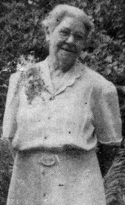
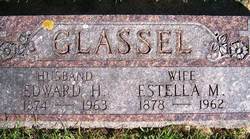
Estella Maude Ripley Glassel
| Birth | : | 30 Mar 1878 Mitchell, Mitchell County, Iowa, USA |
| Death | : | 20 Jul 1962 Osage, Mitchell County, Iowa, USA |
| Burial | : | Sacramento City Cemetery, Sacramento, Sacramento County, USA |
| Coordinate | : | 38.5636864, -121.5009537 |
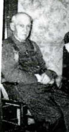
| Description | : | Estella Ripley was born on the Roby farm on the Mitchell corner north of Osage. When she was 6 yrs old her family moved to East Mitchell and she attended the Mitchell Schools. In 1927 she married Edd Glassel. Mrs. Glassel was noted for her beautiful rock gardens and house plants. She had one cactus that almost touched the ceiling in her home. Estella also kept a large garden and around 200 laying hens. She was a charter member of the Mitchell Unity Club and attended church in Mitchell. And was also the Mitchell Centenial Queen... Read More |
frequently asked questions (FAQ):
-
Where is Estella Maude Ripley Glassel's memorial?
Estella Maude Ripley Glassel's memorial is located at: Sacramento City Cemetery, Sacramento, Sacramento County, USA.
-
When did Estella Maude Ripley Glassel death?
Estella Maude Ripley Glassel death on 20 Jul 1962 in Osage, Mitchell County, Iowa, USA
-
Where are the coordinates of the Estella Maude Ripley Glassel's memorial?
Latitude: 38.5636864
Longitude: -121.5009537
Family Members:
Parent
Spouse
Siblings
Flowers:


Nearby Cemetories:
1. Sacramento City Cemetery
Sacramento, Sacramento County, USA
Coordinate: 38.5636864, -121.5009537
2. Buddhist Church of Sacramento Nokotsudo
Sacramento, Sacramento County, USA
Coordinate: 38.5639300, -121.4978400
3. Sunset Hill Cemetery
Sacramento, Sacramento County, USA
Coordinate: 38.5608000, -121.5037300
4. Masonic Lawn Cemetery
Sacramento, Sacramento County, USA
Coordinate: 38.5604720, -121.5032600
5. Odd Fellows Lawn Cemetery and Mausoleum
Sacramento, Sacramento County, USA
Coordinate: 38.5585000, -121.5011000
6. National Shrine of Our Lady of Guadalupe Crypt
Sacramento, Sacramento County, USA
Coordinate: 38.5704800, -121.5014400
7. California State Capitol
Sacramento, Sacramento County, USA
Coordinate: 38.5760994, -121.4931488
8. Saint Joseph Cemetery
Sacramento, Sacramento County, USA
Coordinate: 38.5574989, -121.4835968
9. Holy Ascension Russian Orthodox Cemetery
Sacramento, Sacramento County, USA
Coordinate: 38.5846212, -121.4936736
10. Trinity Episcopal Cathedral Columbarium
Sacramento, Sacramento County, USA
Coordinate: 38.5705500, -121.4723770
11. New Helvetia Cemetery (Defunct)
Sacramento, Sacramento County, USA
Coordinate: 38.5731600, -121.4639900
12. Pho Minh Temple Columbarium
Sacramento, Sacramento County, USA
Coordinate: 38.5340100, -121.4769000
13. East Lawn Memorial Park
Sacramento, Sacramento County, USA
Coordinate: 38.5612960, -121.4492760
14. Saint Rose Cemetery (Defunct)
Sacramento, Sacramento County, USA
Coordinate: 38.5208015, -121.4672012
15. Saint Mary's Catholic Cemetery and Mausoleum
Sacramento, Sacramento County, USA
Coordinate: 38.5298900, -121.4261200
16. Sacramento Memorial Lawn Cemetery
Sacramento, Sacramento County, USA
Coordinate: 38.5146484, -121.4380341
17. Sacramento County Hospital Cemetery
Sacramento, Sacramento County, USA
Coordinate: 38.5289300, -121.4239100
18. Home of Peace Cemetery
Sacramento, Sacramento County, USA
Coordinate: 38.5137558, -121.4382782
19. Russian Orthodox Cemetery
Sacramento, Sacramento County, USA
Coordinate: 38.5268800, -121.4244300
20. Sacramento County Cemetery
Sacramento County, USA
Coordinate: 38.5267900, -121.4233700
21. Sacramento County Veterans Memorial Cemetery
Sacramento, Sacramento County, USA
Coordinate: 38.5252838, -121.4239120
22. Tinh Xa Ngoc An Temple Columbarium
Sacramento, Sacramento County, USA
Coordinate: 38.5190200, -121.4159500
23. Elder Creek Cemetery
Florin, Sacramento County, USA
Coordinate: 38.5111008, -121.4169006
24. Kim Quang Temple Columbarium
Sacramento, Sacramento County, USA
Coordinate: 38.5996600, -121.3904700