
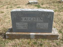
Naomi Esther Moore Laughlin
| Birth | : | 1875 Wheaton, Barry County, Missouri, USA |
| Death | : | 5 Jul 1964 Stella, Newton County, Missouri, USA |
| Burial | : | Camperdown Cemetery, Newtown, City of Sydney, Australia |
| Coordinate | : | -33.8942220, 151.1804900 |
| Plot | : | 6B-11 |
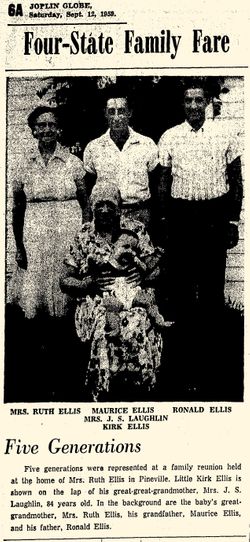
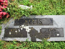
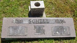
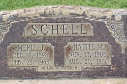
| Description | : | Mrs. Naomi E. Laughlin Anderson Missouri, July 5, 1964. Mrs. Naomi Esther Laughlin, 89 years old, died at 11:30 o'clock Sunday morning at Cardwell Memorial Hospital at Stella where she had been a patient for two days. She had been in ill health two years. Mrs. Laughlin was born at Wheaton in 1875 and was a member of the Roller Methodist Church. Surviving are a son, Wyatt Laughlin of Riverton, Kansas, seven daughters, Mrs. Ruth Ellis of Pineville, Mrs. Esther Schell of Washburn, Missouri, Mrs. Rena Lawson of Ramona, Oklahoma, Mrs. Rachel Bunch of Webb City, Mrs. Hattie Schell of... Read More |
frequently asked questions (FAQ):
-
Where is Naomi Esther Moore Laughlin's memorial?
Naomi Esther Moore Laughlin's memorial is located at: Camperdown Cemetery, Newtown, City of Sydney, Australia.
-
When did Naomi Esther Moore Laughlin death?
Naomi Esther Moore Laughlin death on 5 Jul 1964 in Stella, Newton County, Missouri, USA
-
Where are the coordinates of the Naomi Esther Moore Laughlin's memorial?
Latitude: -33.8942220
Longitude: 151.1804900
Family Members:
Parent
Spouse
Siblings
Children
Flowers:


Nearby Cemetories:
1. Camperdown Cemetery
Newtown, City of Sydney, Australia
Coordinate: -33.8942220, 151.1804900
2. St Luke's Anglican Church
Enmore, Inner West Council, Australia
Coordinate: -33.8989218, 151.1700724
3. St. Peters Cooks River Cemetery
Saint Peters, Inner West Council, Australia
Coordinate: -33.9139390, 151.1775670
4. Devonshire Street Cemetery (Defunct)
Sydney, City of Sydney, Australia
Coordinate: -33.8828080, 151.2066180
5. Pioneers Memorial Park
Leichhardt, Inner West Council, Australia
Coordinate: -33.8780800, 151.1575000
6. St Thomas Becket Churchyard
Lewisham, Inner West Council, Australia
Coordinate: -33.8928760, 151.1480490
7. Balmain Catholic Cemetery (Defunct)
Leichhardt, Inner West Council, Australia
Coordinate: -33.8797270, 151.1523730
8. Old Sydney Burial Ground
Sydney, City of Sydney, Australia
Coordinate: -33.8731750, 151.2063850
9. Parish Church of Saint James
Sydney, City of Sydney, Australia
Coordinate: -33.8693760, 151.2111540
10. Saint Mary's Cathedral
Sydney, City of Sydney, Australia
Coordinate: -33.8708540, 151.2135820
11. St David’s Presbyterian Cemetery
Haberfield, Inner West Council, Australia
Coordinate: -33.8823220, 151.1378500
12. Royal Botanic Gardens
Sydney, City of Sydney, Australia
Coordinate: -33.8647440, 151.2170610
13. St. John's Anglican Church Cemetery
Ashfield, Inner West Council, Australia
Coordinate: -33.8817160, 151.1278730
14. St. Paul's Anglican Church Cemetery
Canterbury, Canterbury-Bankstown Council, Australia
Coordinate: -33.9081600, 151.1236000
15. Botany Wesleyan Cemetery (Defunct)
Botany Bay, Bayside Council, Australia
Coordinate: -33.9421070, 151.1961480
16. Garden Island
Potts Point, City of Sydney, Australia
Coordinate: -33.8613635, 151.2280308
17. Saint Jude's Cemetery
Randwick, Randwick City, Australia
Coordinate: -33.9115460, 151.2417130
18. Holy Trinity Church
Kingsford, Randwick City, Australia
Coordinate: -33.9267060, 151.2321180
19. Mary MacKillop Memorial Chapel
North Sydney, North Sydney Council, Australia
Coordinate: -33.8388250, 151.2049160
20. St Paul's Anglican Church
Burwood, Burwood Municipality, Australia
Coordinate: -33.8816114, 151.1027492
21. St Aidan's Anglican Church
Longueville, Lane Cove Municipality, Australia
Coordinate: -33.8281510, 151.1709560
22. St. Luke's Anglican Church Columbarium
Concord, Canada Bay City, Australia
Coordinate: -33.8678417, 151.1068448
23. Gladesville Asylum Cemetery
Gladesville, Hunter's Hill Municipality, Australia
Coordinate: -33.8393010, 151.1342490
24. Rockdale Uniting Church Cemetery
Rockdale, Bayside Council, Australia
Coordinate: -33.9533350, 151.1381840