
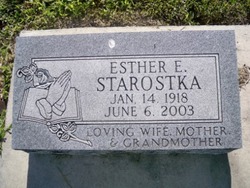
Esther E. Cyza Starostka
| Birth | : | 14 Jan 1918 Duncan, Platte County, Nebraska, USA |
| Death | : | 6 Jun 2003 Osceola, Polk County, Nebraska, USA |
| Burial | : | Bingsjö Kyrkogård, Bingsjo, Rättviks kommun, Sweden |
| Coordinate | : | 61.0230600, 15.6493610 |
| Description | : | Daughter of John & Catherine (Kula) Cyza. Married to Walter F. Starostka on 10-7-1940 at St. Peter's Catholic Church in Fullerton, Nance, NE. Occupation: Homemaker and employee of Dale's Electronics. |
frequently asked questions (FAQ):
-
Where is Esther E. Cyza Starostka's memorial?
Esther E. Cyza Starostka's memorial is located at: Bingsjö Kyrkogård, Bingsjo, Rättviks kommun, Sweden.
-
When did Esther E. Cyza Starostka death?
Esther E. Cyza Starostka death on 6 Jun 2003 in Osceola, Polk County, Nebraska, USA
-
Where are the coordinates of the Esther E. Cyza Starostka's memorial?
Latitude: 61.0230600
Longitude: 15.6493610
Family Members:
Parent

Spouse
Siblings

Flowers:


Nearby Cemetories:
1. Bingsjö Kyrkogård
Bingsjo, Rättviks kommun, Sweden
Coordinate: 61.0230600, 15.6493610
2. Dådrans kyrkogård
Rättviks kommun, Sweden
Coordinate: 60.9410000, 15.5379200
3. Boda Kyrkogård
Boda, Rättviks kommun, Sweden
Coordinate: 61.0115740, 15.2084940
4. Envikens Kyrkogård
Enviken, Falu kommun, Sweden
Coordinate: 60.8056910, 15.7712940
5. Rättviks kyrkogård
Rättviks kommun, Sweden
Coordinate: 60.8909900, 15.0963300
6. Voxna Kyrkogård
Voxna, Ovanåkers kommun, Sweden
Coordinate: 61.3653170, 15.5146930
7. Ovanåker Kyrkogård
Ovanaker, Ovanåkers kommun, Sweden
Coordinate: 61.3638701, 15.9005535
8. Alfta Kyrkogård
Alfta, Ovanåkers kommun, Sweden
Coordinate: 61.3483330, 16.0836110
9. Kristine kyrka
Falun, Falu kommun, Sweden
Coordinate: 60.6077780, 15.6311110
10. Skattunge Kyrkagard
Skattungbyn, Orsa kommun, Sweden
Coordinate: 61.1858797, 14.8368884
11. Leksands kyrkogård
Leksand, Leksands kommun, Sweden
Coordinate: 60.7318690, 14.9810310
12. Sankt Lars Kyrkogård
Bollnas, Bollnäs kommun, Sweden
Coordinate: 61.3461670, 16.3636940
13. Bollnäs Kyrkogård - Nya
Bollnas, Bollnäs kommun, Sweden
Coordinate: 61.3466730, 16.3845040
14. Bollnäs Kyrkogård - Gamla
Bollnas, Bollnäs kommun, Sweden
Coordinate: 61.3464340, 16.3873390
15. Hanebo Church Graveyard
Hanebo, Bollnäs kommun, Sweden
Coordinate: 61.2449170, 16.5563890
16. Vika kyrkogard
Falun, Falu kommun, Sweden
Coordinate: 60.5133980, 15.7138820
17. Gagnefs kyrkogård
Gagnef, Gagnefs kommun, Sweden
Coordinate: 60.5898820, 15.0597170
18. Mora Nya Kyrkogård
Mora, Mora kommun, Sweden
Coordinate: 61.0134033, 14.5714618
19. Ockelbo Kyrkogård
Ockelbo, Ockelbo kommun, Sweden
Coordinate: 60.8873030, 16.7162990
20. Segersta Kyrkogård
Segersta, Bollnäs kommun, Sweden
Coordinate: 61.2683410, 16.6372561
21. Gamla Kyrkogården
Mora, Mora kommun, Sweden
Coordinate: 61.0071510, 14.5415320
22. Gamla Mora kyrkogård
Mora, Sigtuna kommun, Sweden
Coordinate: 61.0074470, 14.5409980
23. Öjung Kapell och Kyrkogård
Ovanaker, Ovanåkers kommun, Sweden
Coordinate: 61.5913170, 15.5672290
24. Rengsjö Kyrkogård
Rengsjo, Bollnäs kommun, Sweden
Coordinate: 61.3624426, 16.6082356