
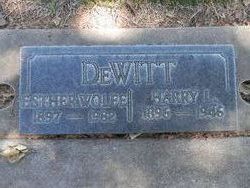
Esther Elizabeth Hayland DeWitt
| Birth | : | 25 Jan 1897 Red Bluff, Tehama County, California, USA |
| Death | : | 15 Jun 1982 Red Bluff, Tehama County, California, USA |
| Burial | : | Oak Hill Cemetery, Red Bluff, Tehama County, USA |
| Coordinate | : | 40.1699982, -122.2433014 |
| Plot | : | Blk M |
| Description | : | Marker inscribed Esther Wolfe DeWitt She married 1) Harry DeWitt: The Sacramento Bee (Sacramento, California) 23 Jun 1926, Wednesday Page 9: Marriage Licenses. DEWITT – HAYLAND – In Red Bluff, Tehama County, June 21, 1926, by Justice E.F. Lennon, Harry L. DeWitt, 30, and Esther Elizabeth Hayland, 21, both of Red Bluff. M2) Mark R. Wolfe. Esther H Dewitt Gender: Female Marriage Date: 3 Sep1957 Marriage Place: USA, Carson City, Nevada Spouse: Mark R Wolfe Marriage Description: Carson Marriage Record Number: 39672083. Carson City, Nevada, U.S., Marriage Index, 1855-1985. She was... Read More |
frequently asked questions (FAQ):
-
Where is Esther Elizabeth Hayland DeWitt's memorial?
Esther Elizabeth Hayland DeWitt's memorial is located at: Oak Hill Cemetery, Red Bluff, Tehama County, USA.
-
When did Esther Elizabeth Hayland DeWitt death?
Esther Elizabeth Hayland DeWitt death on 15 Jun 1982 in Red Bluff, Tehama County, California, USA
-
Where are the coordinates of the Esther Elizabeth Hayland DeWitt's memorial?
Latitude: 40.1699982
Longitude: -122.2433014
Family Members:
Parent

Spouse

Siblings

Flowers:


Nearby Cemetories:
1. Red Bluff Memorial Chapel Mausoleum & Columbarium
Red Bluff, Tehama County, USA
Coordinate: 40.1717130, -122.2466860
2. Saint Mary's Cemetery
Red Bluff, Tehama County, USA
Coordinate: 40.1716995, -122.2521973
3. Growney Ranch Family Cemetery
Red Bluff, Tehama County, USA
Coordinate: 40.1167300, -122.1952500
4. Los Molinos Cemetery
Los Molinos, Tehama County, USA
Coordinate: 40.0475650, -122.1011820
5. Tehama Cemetery
Tehama, Tehama County, USA
Coordinate: 40.0233002, -122.1433029
6. Red Bank Cemetery
Red Bank, Tehama County, USA
Coordinate: 40.1036970, -122.4458540
7. Inks Creek Cemetery
Tehama County, USA
Coordinate: 40.3419800, -122.1297100
8. Cottonwood Creek Ranch Cemetery
Cottonwood, Shasta County, USA
Coordinate: 40.3663100, -122.2598800
9. Cottonwood Cemetery
Cottonwood, Shasta County, USA
Coordinate: 40.3856100, -122.2936500
10. Major Pierson B Reading Family Cemetery
Cottonwood, Shasta County, USA
Coordinate: 40.3924300, -122.2126900
11. Sunset Hill Cemetery
Corning, Tehama County, USA
Coordinate: 39.9271600, -122.1586100
12. Sleepy Hollow Pet Cemetery
Anderson, Shasta County, USA
Coordinate: 40.4199430, -122.2858410
13. Rosewood Cemetery
Rosewood, Tehama County, USA
Coordinate: 40.2685360, -122.5575190
14. New Clairvaux Abbey Cemetery
Vina, Tehama County, USA
Coordinate: 39.9381450, -122.0641890
15. Anderson District Cemetery
Anderson, Shasta County, USA
Coordinate: 40.4419518, -122.2967300
16. Oddfellows Cemetery
Anderson, Shasta County, USA
Coordinate: 40.4431590, -122.2907070
17. Anderson Pioneer Cemetery
Anderson, Shasta County, USA
Coordinate: 40.4439011, -122.2904968
18. Vina Cemetery
Vina, Tehama County, USA
Coordinate: 39.9636440, -121.9957070
19. Lowrey Cemetery
Tehama County, USA
Coordinate: 40.0066986, -122.5635986
20. Cameron-Davis Cemetery
Tehama County, USA
Coordinate: 40.2709800, -121.8778500
21. Parkville Cemetery
Anderson, Shasta County, USA
Coordinate: 40.4640200, -122.1897500
22. Lanes Valley Cemetery
Paynes Creek, Tehama County, USA
Coordinate: 40.3998400, -121.9762400
23. Pinckney Cemetery
Cottonwood, Shasta County, USA
Coordinate: 40.3997002, -122.5180969
24. Kirkwood Cemetery
Corning, Tehama County, USA
Coordinate: 39.8624992, -122.1519012