
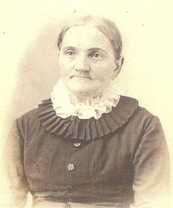

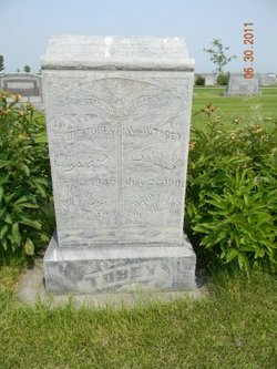
Esther Marie Hunt Tobey
| Birth | : | 29 Aug 1824 |
| Death | : | 3 May 1887 |
| Burial | : | Highbridge Cemetery, Highbridge, Sedgemoor District, England |
| Coordinate | : | 51.2249430, -2.9741730 |
| Description | : | age 62years,8months, 4days |
frequently asked questions (FAQ):
-
Where is Esther Marie Hunt Tobey's memorial?
Esther Marie Hunt Tobey's memorial is located at: Highbridge Cemetery, Highbridge, Sedgemoor District, England.
-
When did Esther Marie Hunt Tobey death?
Esther Marie Hunt Tobey death on 3 May 1887 in
-
Where are the coordinates of the Esther Marie Hunt Tobey's memorial?
Latitude: 51.2249430
Longitude: -2.9741730
Family Members:
Parent
Spouse
Siblings
Children


Nearby Cemetories:
1. Highbridge Cemetery
Highbridge, Sedgemoor District, England
Coordinate: 51.2249430, -2.9741730
2. Convent of La Retraite
Burnham-on-Sea, Sedgemoor District, England
Coordinate: 51.2346309, -2.9926981
3. Burnham-on-Sea Cemetery
Burnham-on-Sea, Sedgemoor District, England
Coordinate: 51.2408600, -2.9933900
4. St. Andrew's Churchyard
Burnham-on-Sea, Sedgemoor District, England
Coordinate: 51.2395800, -2.9977870
5. Saint Peter and All Hallows Churchyard
West Huntspill, Sedgemoor District, England
Coordinate: 51.2041900, -2.9966370
6. St Michael and All Angels Parish Churchyard
Brent Knoll, Sedgemoor District, England
Coordinate: 51.2520000, -2.9539000
7. All Saints Churchyard
East Huntspill, Sedgemoor District, England
Coordinate: 51.2015000, -2.9405700
8. Sedgemoor Crematorium
Sedgemoor District, England
Coordinate: 51.1909300, -3.0005180
9. St. Mary the Virgin Churchyard
East Brent, Sedgemoor District, England
Coordinate: 51.2624370, -2.9418620
10. Pawlett Methodist (Carter Memorial Wesleyan)
Pawlett, Sedgemoor District, England
Coordinate: 51.1845660, -3.0126480
11. Saint Mary Magdalene Churchyard
Berrow, Sedgemoor District, England
Coordinate: 51.2669160, -3.0136980
12. St. John The Baptist Churchyard
Pawlett, Sedgemoor District, England
Coordinate: 51.1789100, -3.0012650
13. Saint Michael and All Angels Churchyard
Puriton, Sedgemoor District, England
Coordinate: 51.1706000, -2.9735000
14. Holy Cross Churchyard
Mark, Sedgemoor District, England
Coordinate: 51.2269640, -2.8860140
15. St Christopher's Churchyard
Lympsham, Sedgemoor District, England
Coordinate: 51.2826740, -2.9546028
16. Blessed Virgin Mary Churchyard
Woolavington, Sedgemoor District, England
Coordinate: 51.1704000, -2.9341000
17. Blessed Virgin Mary Extension Cemetery
Woolavington, Sedgemoor District, England
Coordinate: 51.1705660, -2.9329110
18. St. John the Baptist Churchyard
Biddisham, Sedgemoor District, England
Coordinate: 51.2764090, -2.8878950
19. St. Mary's Churchyard
Cossington, Sedgemoor District, England
Coordinate: 51.1580085, -2.9213149
20. Saint Michael & All Angels Churchyard
Bawdrip, Sedgemoor District, England
Coordinate: 51.1517260, -2.9429330
21. Saint Bridget Churchyard
Brean, Sedgemoor District, England
Coordinate: 51.2983000, -3.0100000
22. St. Philip and St. James Churchyard
Burtle, Sedgemoor District, England
Coordinate: 51.1856232, -2.8665409
23. Otterhampton Extension Cemetery
Otterhampton, Sedgemoor District, England
Coordinate: 51.1828490, -3.0791630
24. All Saints Churchyard
Otterhampton, Sedgemoor District, England
Coordinate: 51.1829540, -3.0796420