

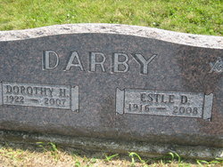
Estle Dee Darby
| Birth | : | 12 Jul 1916 Mills County, Iowa, USA |
| Death | : | 4 Dec 2008 Red Oak, Montgomery County, Iowa, USA |
| Burial | : | Farm Creek Cemetery, Henderson, Mills County, USA |
| Coordinate | : | 41.1319008, -95.4186020 |
| Description | : | Estle entered this life in Anderson Township. The first 15 years of Estle's life was spent near Henderson, Iowa. His family then moved to Hermitage, Missouri where they lived for a short time before returning to Henderson where he attended Henderson High School. He married Dorothy Wilhelm January 31, 1940 in Glenwood, Iowa. They farmed for many years near Emerson, Iowa, as well as selling Moorman's Feeds, and carpentry work. When they retired, they moved to Branson, Missouri until 1995 when they moved back to Emerson. Dorothy preceded Estle in death on March13, 2007. At... Read More |
frequently asked questions (FAQ):
-
Where is Estle Dee Darby's memorial?
Estle Dee Darby's memorial is located at: Farm Creek Cemetery, Henderson, Mills County, USA.
-
When did Estle Dee Darby death?
Estle Dee Darby death on 4 Dec 2008 in Red Oak, Montgomery County, Iowa, USA
-
Where are the coordinates of the Estle Dee Darby's memorial?
Latitude: 41.1319008
Longitude: -95.4186020
Family Members:
Parent
Spouse

Siblings
Flowers:


Nearby Cemetories:
1. Farm Creek Cemetery
Henderson, Mills County, USA
Coordinate: 41.1319008, -95.4186020
2. Saylers Farm Cemetery
Henderson, Mills County, USA
Coordinate: 41.1083300, -95.4919440
3. Macedonia Cemetery
Macedonia, Pottawattamie County, USA
Coordinate: 41.1921997, -95.4167023
4. Buckner Cemetery
Wales, Montgomery County, USA
Coordinate: 41.1595600, -95.3440700
5. Wesley Chapel Cemetery
Henderson, Mills County, USA
Coordinate: 41.1019249, -95.4987793
6. Old Town Cemetery
Macedonia, Pottawattamie County, USA
Coordinate: 41.2030983, -95.4421997
7. Mormon Cemetery
Macedonia, Pottawattamie County, USA
Coordinate: 41.1885986, -95.3557663
8. Gomer Cemetery
Wales, Montgomery County, USA
Coordinate: 41.1171989, -95.3082962
9. Lowens Cemetery
Garfield Township, Montgomery County, USA
Coordinate: 41.0527728, -95.3758292
10. Cotten Cemetery
Mills County, USA
Coordinate: 41.0845000, -95.5167000
11. Bradway Farm Cemetery
Macedonia, Pottawattamie County, USA
Coordinate: 41.2083300, -95.3336500
12. Emerson Cemetery
Emerson, Mills County, USA
Coordinate: 41.0325012, -95.4021988
13. Wheeler Grove Cemetery
Macedonia, Pottawattamie County, USA
Coordinate: 41.2131691, -95.3393631
14. Center Ridge Cemetery
Montgomery County, USA
Coordinate: 41.1452141, -95.2787018
15. Carson Cemetery
Carson, Pottawattamie County, USA
Coordinate: 41.2392006, -95.4044037
16. North Grove Cemetery
Hastings, Mills County, USA
Coordinate: 41.0161018, -95.4618988
17. Wearin Cemetery
Malvern, Mills County, USA
Coordinate: 41.0395000, -95.5313000
18. Hastings Cemetery
Hastings, Mills County, USA
Coordinate: 41.0097008, -95.4993973
19. L Laire Property Cemetery (Defunct)
Sherman Township, Montgomery County, USA
Coordinate: 41.0958257, -95.2224927
20. East Liberty Cemetery
Malvern, Mills County, USA
Coordinate: 41.0592346, -95.6005020
21. Belknap Cemetery
Oakland, Pottawattamie County, USA
Coordinate: 41.2924995, -95.4424973
22. South Grove Cemetery
Mills County, USA
Coordinate: 40.9775009, -95.4931030
23. Silver City Cemetery
Silver City, Mills County, USA
Coordinate: 41.1042442, -95.6380005
24. Saint Marys Cemetery
Red Oak, Montgomery County, USA
Coordinate: 41.0447006, -95.2275009