
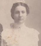

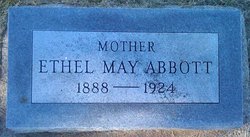

Ethel May Hart Abbott
| Birth | : | 2 Aug 1888 McPherson, McPherson County, Kansas, USA |
| Death | : | 9 Jul 1924 McCook, Red Willow County, Nebraska, USA |
| Burial | : | Mount Hope Cemetery, Clyde, Cloud County, USA |
| Coordinate | : | 39.5969009, -97.4116974 |
| Plot | : | 8-20 |
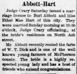
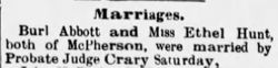
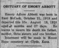
| Description | : | Ethel May Hart Abbott, daughter of William Andrew Hart and Isabelle Florence Stansbury, was born August 1888 in Rantoul, Franklin County, Kansas. She passed away in July 1924 in McCook County, Nebraska. She was married Burl Robert Sewell Abbott, son of Sewell August Abbott and Martha Ann Smock (January 30, 1881 in Osborne, Norton County, Kansas) He passed away on August 12, 1926 in McCook, Nebraska. She was preceded in death by son, Emory who died in 1920. She is survived by the following children; Mildred Perkins and husband, William of Silverton, Oregon, Howard Lawrence Abbott,... Read More |
frequently asked questions (FAQ):
-
Where is Ethel May Hart Abbott's memorial?
Ethel May Hart Abbott's memorial is located at: Mount Hope Cemetery, Clyde, Cloud County, USA.
-
When did Ethel May Hart Abbott death?
Ethel May Hart Abbott death on 9 Jul 1924 in McCook, Red Willow County, Nebraska, USA
-
Where are the coordinates of the Ethel May Hart Abbott's memorial?
Latitude: 39.5969009
Longitude: -97.4116974
Family Members:
Parent
Spouse
Children

Flowers:


Nearby Cemetories:
1. Mount Calvary Cemetery
Clyde, Cloud County, USA
Coordinate: 39.5917015, -97.4143982
2. Cedar Grove Cemetery
Clyde, Cloud County, USA
Coordinate: 39.5494003, -97.4056015
3. Pleasant View Cemetery
Ames, Cloud County, USA
Coordinate: 39.5346985, -97.4431000
4. Walnut Grove Cemetery
Cloud County, USA
Coordinate: 39.5699997, -97.4993973
5. Agenda Cemetery
Agenda, Republic County, USA
Coordinate: 39.6761017, -97.4336014
6. Saint Joseph Cemetery
Saint Joseph, Cloud County, USA
Coordinate: 39.5074941, -97.4022328
7. Beck Family Cemetery
Agenda, Republic County, USA
Coordinate: 39.6818000, -97.4863000
8. Green Mound Cemetery
Rice, Cloud County, USA
Coordinate: 39.5248450, -97.5081630
9. Hollis Cemetery
Cloud County, USA
Coordinate: 39.6383018, -97.5361023
10. Rice Cemetery
Rice, Cloud County, USA
Coordinate: 39.5614014, -97.5552979
11. Nelson Cemetery
Rice, Cloud County, USA
Coordinate: 39.5257988, -97.5410995
12. Riverdale Cemetery
Clay County, USA
Coordinate: 39.5106010, -97.2930984
13. Willoughby Cemetery
Agenda, Republic County, USA
Coordinate: 39.7402992, -97.4244003
14. Union Cemetery
Wayne, Republic County, USA
Coordinate: 39.6977997, -97.5457993
15. Saint Peters Cemetery
Aurora, Cloud County, USA
Coordinate: 39.4763985, -97.5180969
16. Princeville Cemetery
Aurora, Cloud County, USA
Coordinate: 39.4672012, -97.5010986
17. Iwacura Cemetery
Morganville, Clay County, USA
Coordinate: 39.4550000, -97.3510000
18. Gotland Cemetery
Sibley Township, Cloud County, USA
Coordinate: 39.6091995, -97.6125031
19. French Presbyterian Church Cemetery
Cloud County, USA
Coordinate: 39.4395200, -97.4148290
20. Sherman Cemetery
Morganville, Clay County, USA
Coordinate: 39.5316300, -97.2243700
21. Zion Cemetery
Agenda, Republic County, USA
Coordinate: 39.6749992, -97.5939026
22. Rose Hill Cemetery
Wayne, Republic County, USA
Coordinate: 39.7111015, -97.5661011
23. Minersville Cemetery
Talmo, Republic County, USA
Coordinate: 39.6568330, -97.6229250
24. Bloom Cemetery
Morganville, Clay County, USA
Coordinate: 39.4519005, -97.2778015