
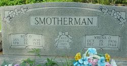
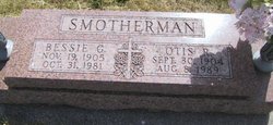
Roy Oscar Smotherman
| Birth | : | 22 Jan 1898 Shannon County, Missouri, USA |
| Death | : | 14 Apr 1972 |
| Burial | : | All Saints Churchyard, Biddenden, Ashford Borough, England |
| Coordinate | : | 51.1150740, 0.6403990 |
| Inscription | : | Married 14 June 1923 |
| Description | : | Roy Oscar Smotherman in the U.S., World War II Draft Cards Young Men, 1940-1947 Name: Roy Oscar Smotherman Gender: Male Race: White Age: 43 Relationship to Draftee: Self (Head) Birth Date: 22 Jan 1899 Birth Place: Shannon, Missouri Residence Place: Minburn, Dallas, Iowa, USA Registration Date: 16 Feb 1942 Registration Place: Iowa, USA Employer: Farm RFD Height: 5 4 Weight: 130 Complexion: Dark Hair Color: Brown Eye Color: Brown Next of Kin: Wrena Smotherman Household Members Relationship Roy Oscar Smotherman Self (Head) |
frequently asked questions (FAQ):
-
Where is Roy Oscar Smotherman's memorial?
Roy Oscar Smotherman's memorial is located at: All Saints Churchyard, Biddenden, Ashford Borough, England.
-
When did Roy Oscar Smotherman death?
Roy Oscar Smotherman death on 14 Apr 1972 in
-
Where are the coordinates of the Roy Oscar Smotherman's memorial?
Latitude: 51.1150740
Longitude: 0.6403990
Family Members:
Parent
Spouse
Siblings

Children


Nearby Cemetories:
1. All Saints Churchyard
Biddenden, Ashford Borough, England
Coordinate: 51.1150740, 0.6403990
2. Ebeneezer Chapel
Biddenden, Ashford Borough, England
Coordinate: 51.1383320, 0.6416030
3. St. Mary's Churchyard
Frittenden, Tunbridge Wells Borough, England
Coordinate: 51.1391190, 0.5904720
4. St. Michael and All Angels Churchyard
Tenterden, Ashford Borough, England
Coordinate: 51.0867424, 0.6894140
5. Frittenden Burial Gound
Frittenden, Tunbridge Wells Borough, England
Coordinate: 51.1428480, 0.5870820
6. St. Michael the Archangel Churchyard
Smarden, Ashford Borough, England
Coordinate: 51.1490030, 0.6861940
7. St. Mary the Virgin Churchyard
High Halden, Ashford Borough, England
Coordinate: 51.1028950, 0.7148620
8. Sissinghurst Cemetery
Sissinghurst, Tunbridge Wells Borough, England
Coordinate: 51.1095310, 0.5629240
9. Tenterden Cemetery
Tenterden, Ashford Borough, England
Coordinate: 51.0676820, 0.6737140
10. Headcorn Baptist Churchyard
Headcorn, Maidstone Borough, England
Coordinate: 51.1674156, 0.6247670
11. Headcorn Parish Burial Ground
Headcorn, Maidstone Borough, England
Coordinate: 51.1671257, 0.6204750
12. Unitarian Old Meeting House
Tenterden, Ashford Borough, England
Coordinate: 51.0717468, 0.6906880
13. Headcorn Methodist Churchyard
Headcorn, Maidstone Borough, England
Coordinate: 51.1674940, 0.6205670
14. Headcorn War Memorial
Headcorn, Maidstone Borough, England
Coordinate: 51.1677480, 0.6212560
15. St. Peter and St. Paul Churchyard
Headcorn, Maidstone Borough, England
Coordinate: 51.1678543, 0.6203760
16. Station Road Extension
Tenterden, Ashford Borough, England
Coordinate: 51.0686640, 0.6852830
17. St. Mildred's Churchyard
Tenterden, Ashford Borough, England
Coordinate: 51.0686264, 0.6870960
18. Cranbrook Cemetery
Cranbrook, Tunbridge Wells Borough, England
Coordinate: 51.0962250, 0.5541360
19. St. George Parish Churchyard
Benenden, Tunbridge Wells Borough, England
Coordinate: 51.0648720, 0.5794570
20. St. Mary the Virgin Churchyard
Rolvenden, Ashford Borough, England
Coordinate: 51.0506590, 0.6310280
21. St David's Bridge Strict Baptist Chapel
Cranbrook, Tunbridge Wells Borough, England
Coordinate: 51.0953430, 0.5378980
22. St Dunstan's Churchyard
Cranbrook, Tunbridge Wells Borough, England
Coordinate: 51.0973030, 0.5363690
23. All Saints Church
Staplehurst, Maidstone Borough, England
Coordinate: 51.1582160, 0.5527170
24. St. Margaret's Churchyard
Bethersden, Ashford Borough, England
Coordinate: 51.1291440, 0.7538760