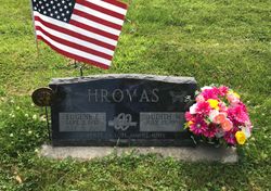
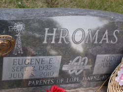
Eugene Edward Hromas
| Birth | : | 2 Sep 1932 Ulysses, Butler County, Nebraska, USA |
| Death | : | 8 Jul 2010 Ulysses, Butler County, Nebraska, USA |
| Burial | : | All Saints Churchyard, Winthorpe, Newark and Sherwood District, England |
| Coordinate | : | 53.0983646, -0.7884366 |
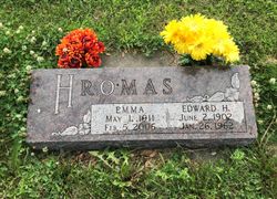
| Description | : | Son of Edward Henry and Emma (Krepcik) Hromas and passed away July 8, 2010 at his home at the age of 77 years, 10 months and 6 days. Gene was a 1949 graduate of Ulysses High School. Gene served in the U.S. Army from March of 1953 to January of 1955. On June 3, 1956, Gene was united in marriage to Judi May Haase at St. John Lutheran Church in Seward, Nebraska. Their union was blessed with three children, Lori, Janene and Hope. He was employed with Goodyear Tire and Rubber Company for 35 years. Gene was a member of St.... Read More |
frequently asked questions (FAQ):
-
Where is Eugene Edward Hromas's memorial?
Eugene Edward Hromas's memorial is located at: All Saints Churchyard, Winthorpe, Newark and Sherwood District, England.
-
When did Eugene Edward Hromas death?
Eugene Edward Hromas death on 8 Jul 2010 in Ulysses, Butler County, Nebraska, USA
-
Where are the coordinates of the Eugene Edward Hromas's memorial?
Latitude: 53.0983646
Longitude: -0.7884366
Family Members:
Parent
Flowers:
Nearby Cemetories:
1. All Saints Churchyard
Winthorpe, Newark and Sherwood District, England
Coordinate: 53.0983646, -0.7884366
2. St Wilfred Churchyard
South Muskham, Newark and Sherwood District, England
Coordinate: 53.1071300, -0.8156400
3. St. Mary Magdalene Church
Newark-on-Trent, Newark and Sherwood District, England
Coordinate: 53.0766983, -0.8085000
4. St Bartholomew Churchyard
Langford, Newark and Sherwood District, England
Coordinate: 53.1225760, -0.7743940
5. Newark-on-Trent Cemetery
Newark-on-Trent, Newark and Sherwood District, England
Coordinate: 53.0692040, -0.7988660
6. St Wilfrid's Churchyard
Kelham, Newark and Sherwood District, England
Coordinate: 53.0901100, -0.8459700
7. Balderton Methodist Church
Newark-on-Trent, Newark and Sherwood District, England
Coordinate: 53.0551620, -0.7823410
8. St Giles Churchyard
Balderton, Newark and Sherwood District, England
Coordinate: 53.0553010, -0.7780750
9. St. Michael's Churchyard
Averham, Newark and Sherwood District, England
Coordinate: 53.0810080, -0.8549840
10. Balderton Cemetery
Balderton, Newark and Sherwood District, England
Coordinate: 53.0539100, -0.7877400
11. St. John the Baptist Churchyard
Collingham, Newark and Sherwood District, England
Coordinate: 53.1425550, -0.7656640
12. St Giles Churchyard
Cromwell, Newark and Sherwood District, England
Coordinate: 53.1449750, -0.8063850
13. All Saints Churchyard
Hawton, Newark and Sherwood District, England
Coordinate: 53.0513890, -0.8258330
14. Farndon Municipal Cemetery
Farndon, Newark and Sherwood District, England
Coordinate: 53.0606540, -0.8487310
15. Collingham North All Saints Churchyard
Collingham, Newark and Sherwood District, England
Coordinate: 53.1490600, -0.7607900
16. St. Laurence Churchyard
Norwell, Newark and Sherwood District, England
Coordinate: 53.1474220, -0.8418600
17. All Saints Churchyard
Beckingham, North Kesteven District, England
Coordinate: 53.0740990, -0.6945420
18. All Saints Churchyard
Stapleford, North Kesteven District, England
Coordinate: 53.1082000, -0.6776500
19. St Andrew Churchyard
Caunton, Newark and Sherwood District, England
Coordinate: 53.1322090, -0.8869640
20. St Michael's Church
Norton Disney, North Kesteven District, England
Coordinate: 53.1204000, -0.6795000
21. St Mary's Churchyard
Carlton-on-Trent, Newark and Sherwood District, England
Coordinate: 53.1665950, -0.8058160
22. St Laurence Churchyard
Thorpe, Newark and Sherwood District, England
Coordinate: 53.0428100, -0.8575900
23. St Peter & St Paul's Churchyard
Upton, Newark and Sherwood District, England
Coordinate: 53.0805800, -0.9014900
24. Holy Trinity Churchyard
Rolleston, Newark and Sherwood District, England
Coordinate: 53.0646500, -0.8944500


