
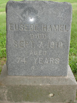
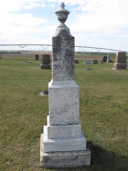
Eusebe Hamel
| Birth | : | 27 May 1844 Nicolet, Centre-du-Quebec Region, Quebec, Canada |
| Death | : | 7 Sep 1918 Saint Joseph, Cloud County, Kansas, USA |
| Burial | : | Saint Joseph Cemetery, Saint Joseph, Cloud County, USA |
| Coordinate | : | 39.5074941, -97.4022328 |
| Inscription | : | Aged 74 years |
| Description | : | Eusebe Hamel (74285606) Clyde Voice-Republican Thursday September 26, 1918 Page 1 Obituary Eusebe Hamel was born at St. Gertrude, Three Rivers, Province of Quebec, Canada, May 2, 1842 and departed this life Saturday, September 7, 1918, at 5:00 o’clock A.M., aged 76 years, 4 months and 5 days. He succumbed to dropsy after an illness of almost three years, suffering untold agonies, and yet uncomplainingly bore the cross of pain. During all his illness he never enjoyed the comforts of a bed. Not one murmur of pain ever crossed his lips. He remained cheerful throughout and died as... Read More |
frequently asked questions (FAQ):
-
Where is Eusebe Hamel's memorial?
Eusebe Hamel's memorial is located at: Saint Joseph Cemetery, Saint Joseph, Cloud County, USA.
-
When did Eusebe Hamel death?
Eusebe Hamel death on 7 Sep 1918 in Saint Joseph, Cloud County, Kansas, USA
-
Where are the coordinates of the Eusebe Hamel's memorial?
Latitude: 39.5074941
Longitude: -97.4022328
Family Members:
Parent
Spouse
Siblings
Children

Flowers:


Nearby Cemetories:
1. Saint Joseph Cemetery
Saint Joseph, Cloud County, USA
Coordinate: 39.5074941, -97.4022328
2. Pleasant View Cemetery
Ames, Cloud County, USA
Coordinate: 39.5346985, -97.4431000
3. Cedar Grove Cemetery
Clyde, Cloud County, USA
Coordinate: 39.5494003, -97.4056015
4. Iwacura Cemetery
Morganville, Clay County, USA
Coordinate: 39.4550000, -97.3510000
5. French Presbyterian Church Cemetery
Cloud County, USA
Coordinate: 39.4395200, -97.4148290
6. Green Mound Cemetery
Rice, Cloud County, USA
Coordinate: 39.5248450, -97.5081630
7. Riverdale Cemetery
Clay County, USA
Coordinate: 39.5106010, -97.2930984
8. Mount Calvary Cemetery
Clyde, Cloud County, USA
Coordinate: 39.5917015, -97.4143982
9. Princeville Cemetery
Aurora, Cloud County, USA
Coordinate: 39.4672012, -97.5010986
10. Mount Hope Cemetery
Clyde, Cloud County, USA
Coordinate: 39.5969009, -97.4116974
11. Saint Peters Cemetery
Aurora, Cloud County, USA
Coordinate: 39.4763985, -97.5180969
12. Walnut Grove Cemetery
Cloud County, USA
Coordinate: 39.5699997, -97.4993973
13. Nelson Cemetery
Rice, Cloud County, USA
Coordinate: 39.5257988, -97.5410995
14. Bloom Cemetery
Morganville, Clay County, USA
Coordinate: 39.4519005, -97.2778015
15. Lincoln Cemetery
Clay Center, Clay County, USA
Coordinate: 39.4230995, -97.2930984
16. Sulphur Springs Cemetery
Aurora, Cloud County, USA
Coordinate: 39.4086610, -97.4986840
17. Rice Cemetery
Rice, Cloud County, USA
Coordinate: 39.5614014, -97.5552979
18. Sherman Cemetery
Morganville, Clay County, USA
Coordinate: 39.5316300, -97.2243700
19. Smith Grave
Miltonvale, Cloud County, USA
Coordinate: 39.3645300, -97.4308700
20. Hollis Cemetery
Cloud County, USA
Coordinate: 39.6383018, -97.5361023
21. Norwegian Lutheran Cemetery
Clay Center, Clay County, USA
Coordinate: 39.5027900, -97.1828200
22. Agenda Cemetery
Agenda, Republic County, USA
Coordinate: 39.6761017, -97.4336014
23. Morganville City Cemetery
Morganville, Clay County, USA
Coordinate: 39.4733009, -97.1819000
24. Miltonvale Cemetery
Miltonvale, Cloud County, USA
Coordinate: 39.3358002, -97.4447021