
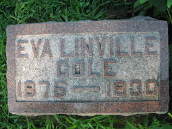

Eva Linville Cole
| Birth | : | 18 Sep 1875 Randolph, Fremont County, Iowa, USA |
| Death | : | 22 Nov 1930 Council Bluffs, Pottawattamie County, Iowa, USA |
| Burial | : | Pine Grove Cemetery, Boylston, Worcester County, USA |
| Coordinate | : | 42.3582993, -71.7431030 |
| Plot | : | 1st Addition #157 |
| Description | : | Mrs. Ernest Cole Dies After Operation Death Came Saturday in Edmundson Hosoital: Funeral Tuesday Emerson, Nov. 25.—This community was saddened Saturday when word came of the death of Mrs. Ernest Cole at the Jennie Edmundson hospital In Councl Bluffs. She hadn't been well all fall and it was in the hope that she might be benefitted that she entered the hospital for treatment two weeks ago. on Wednesday she underwent an operation for goitre from which she seemed unable to rally, the end coming shortly before noon on Saturday. Funeral services were held at the home southeast of Emerson Tuesday afternoon at 2 o'clock, conducted... Read More |
frequently asked questions (FAQ):
-
Where is Eva Linville Cole's memorial?
Eva Linville Cole's memorial is located at: Pine Grove Cemetery, Boylston, Worcester County, USA.
-
When did Eva Linville Cole death?
Eva Linville Cole death on 22 Nov 1930 in Council Bluffs, Pottawattamie County, Iowa, USA
-
Where are the coordinates of the Eva Linville Cole's memorial?
Latitude: 42.3582993
Longitude: -71.7431030
Family Members:
Spouse
Children
Flowers:


Nearby Cemetories:
1. Pine Grove Cemetery
Boylston, Worcester County, USA
Coordinate: 42.3582993, -71.7431030
2. Old Burial Ground
Boylston, Worcester County, USA
Coordinate: 42.3515700, -71.7355300
3. Saint Lukes Cemetery
West Boylston, Worcester County, USA
Coordinate: 42.3833008, -71.7568970
4. Mount Vernon Cemetery
West Boylston, Worcester County, USA
Coordinate: 42.3634650, -71.7804030
5. Beaman Cemetery
West Boylston, Worcester County, USA
Coordinate: 42.3649590, -71.7803600
6. High Plains Cemetery
West Boylston, Worcester County, USA
Coordinate: 42.3889008, -71.7972031
7. Reservoir Pines Cemetery
Clinton, Worcester County, USA
Coordinate: 42.4084900, -71.7109700
8. Cookshire Cemetery
Sterling, Worcester County, USA
Coordinate: 42.4108500, -71.7734800
9. Fairbank Burial Ground
Sterling, Worcester County, USA
Coordinate: 42.4152600, -71.7320000
10. Mountain View Cemetery
Shrewsbury, Worcester County, USA
Coordinate: 42.2999306, -71.7147598
11. Legg Cemetery
Sterling, Worcester County, USA
Coordinate: 42.4070020, -71.7986150
12. West Main Street Cemetery
Shrewsbury, Worcester County, USA
Coordinate: 42.2912600, -71.7420000
13. Notre Dame du Lac Cemetery
Worcester, Worcester County, USA
Coordinate: 42.2910170, -71.7681030
14. Woodlawn Cemetery
Clinton, Worcester County, USA
Coordinate: 42.4185982, -71.6889038
15. Howard Street Cemetery
Northborough, Worcester County, USA
Coordinate: 42.3249000, -71.6475400
16. Chocksett Burial Ground
Sterling, Worcester County, USA
Coordinate: 42.4377000, -71.7555400
17. Old Burying Ground
Berlin, Worcester County, USA
Coordinate: 42.3811646, -71.6375351
18. Saint John's Cemetery
Lancaster, Worcester County, USA
Coordinate: 42.4328003, -71.6977997
19. Hillside Cemetery
Sterling, Worcester County, USA
Coordinate: 42.4410000, -71.7492570
20. Oak Hill Cemetery
Sterling, Worcester County, USA
Coordinate: 42.4417000, -71.7493973
21. Saint Anne's Cemetery
Shrewsbury, Worcester County, USA
Coordinate: 42.2746300, -71.7485400
22. South Berlin Cemetery
Berlin, Worcester County, USA
Coordinate: 42.3652992, -71.6292038
23. Saint Francis Episcopal Church Memorial Garden
Holden, Worcester County, USA
Coordinate: 42.3522800, -71.8588700
24. Old Burying Ground
Holden, Worcester County, USA
Coordinate: 42.3505800, -71.8626000