
| Birth | : | 21 Mar 1903 Shannon County, Missouri, USA |
| Death | : | 9 Sep 1924 Howell County, Missouri, USA |
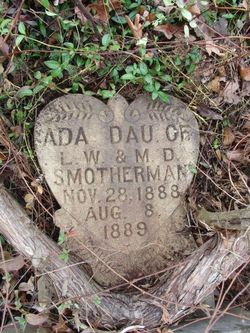
| Burial | : | Pleasant Grove Cemetery, Teresita, Shannon County, USA |
| Coordinate | : | 36.9742012, -91.6206970 |
| Description | : | Son of L. W. and M. D. Smotherman. Died by suicide. Evert Smotherman in the 1910 United States Federal Census Name: Evert Smotherman Age in 1910: 7 Birth Date: 1903 [1903] Birthplace: Missouri Home in 1910: Goldsberry, Howell, Missouri, USA Race: White Gender: Male Relation to Head of House: Son Marital Status: Single Father's Name: Luther Smotherman Father's Birthplace: Kentucky Mother's Name: Malinda Smotherman Mother's Birthplace: Missouri Attended School: Yes Neighbors: View others on page Household Members Age Relationship Luther Smotherman 50 Head Malinda Smotherman 44 Wife Alonzo Smotherman 19 Son Grover Smotherman 17 Son Teat Smotherman 14 Daughter |
frequently asked questions (FAQ):
-
Where is Evert Smotherman's memorial?
Evert Smotherman's memorial is located at: Pleasant Grove Cemetery, Teresita, Shannon County, USA.
-
When did Evert Smotherman death?
Evert Smotherman death on 9 Sep 1924 in Howell County, Missouri, USA
-
Where are the coordinates of the Evert Smotherman's memorial?
Latitude: 36.9742012
Longitude: -91.6206970
Family Members:
Parent

Siblings
Flowers:


Nearby Cemetories:
1. Pleasant Grove Cemetery
Teresita, Shannon County, USA
Coordinate: 36.9742012, -91.6206970
2. Montier Cemetery
Montier, Shannon County, USA
Coordinate: 36.9847984, -91.5754013
3. Pilgrim Rest Cemetery
Teresita, Shannon County, USA
Coordinate: 37.0189018, -91.6485977
4. New Salem Cemetery
Teresita, Shannon County, USA
Coordinate: 36.9239006, -91.6027985
5. Veterans Memorial Cemetery
Mountain View, Howell County, USA
Coordinate: 36.9975014, -91.6869965
6. Turkey Oak Cemetery
Montier, Shannon County, USA
Coordinate: 37.0203018, -91.5768967
7. Greenlawn Cemetery
Mountain View, Howell County, USA
Coordinate: 36.9975014, -91.6892014
8. Mountain View Cemetery
Mountain View, Howell County, USA
Coordinate: 36.9972992, -91.6904984
9. Chapel Hill Cemetery
Chapel, Howell County, USA
Coordinate: 36.9358290, -91.6826140
10. Dunkard Cemetery
Montier, Shannon County, USA
Coordinate: 37.0208015, -91.5580978
11. Corinth Cemetery
Birch Tree, Shannon County, USA
Coordinate: 36.9169998, -91.5661011
12. Saint John Vianney Catholic Cemetery
Mountain View, Howell County, USA
Coordinate: 37.0037498, -91.7072525
13. Padgett Cemetery
Mountain View, Howell County, USA
Coordinate: 36.9727173, -91.7155533
14. Old Baptist Cemetery
Birch Tree, Shannon County, USA
Coordinate: 36.9798775, -91.5186768
15. Brown-DePriest Cemetery
Birch Tree, Shannon County, USA
Coordinate: 36.9674988, -91.5000000
16. Bethlehem Cemetery
Thomasville, Oregon County, USA
Coordinate: 36.8861389, -91.5680008
17. Berea Mennonite Cemetery
Birch Tree, Shannon County, USA
Coordinate: 37.0246010, -91.5110016
18. Forest Dell Ebenezer Cemetery
Mountain View, Howell County, USA
Coordinate: 36.9328003, -91.7403030
19. Warm Corners Cemetery
Birch Tree, Shannon County, USA
Coordinate: 36.9653015, -91.4880981
20. Oak Forest Cemetery
Birch Tree, Shannon County, USA
Coordinate: 36.9818993, -91.4847031
21. Gill Cemetery
Mountain View, Howell County, USA
Coordinate: 37.0224991, -91.7500000
22. Center Hill Cemetery
Chapel, Howell County, USA
Coordinate: 36.9415016, -91.7610016
23. Ledbetter Cemetery
Spring Creek, Oregon County, USA
Coordinate: 36.8566080, -91.5501210
24. New Salem Cemetery
Mountain View, Howell County, USA
Coordinate: 37.0278015, -91.7727966