
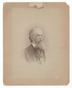
Ezekiel Andrus Colman
| Birth | : | 10 Aug 1814 Ashby, Middlesex County, Massachusetts, USA |
| Death | : | 11 Dec 1898 San Diego, San Diego County, California, USA |
| Burial | : | Oak Hill Cemetery, Lawrence, Douglas County, USA |
| Coordinate | : | 38.9589005, -95.2118988 |
| Description | : | Ezekiel Andrus Colman and Mary Jane Wendell Colman. Ezekiel Andrus Colman, the son of Cyrus and Lydia Townsend Miles Colman, was born in Ashby, Massachusetts on August 10, 1814. Mary Jane Wendell was born October 16, 1817 in Salem, Massachusetts. They married on November 22, 1838 in Salem, Massachusetts. Colman was involved in wallpaper manufacturing until the pair settled in Lawrence, Kansas in 1854. Ardent Abolitionists, the Colmans joined the fourth Emigrant Aid party. For nearly two years, they lived on a farm three miles southwest of Lawrence, then moved into town to run a grocery store. In 1858, they... Read More |
frequently asked questions (FAQ):
-
Where is Ezekiel Andrus Colman's memorial?
Ezekiel Andrus Colman's memorial is located at: Oak Hill Cemetery, Lawrence, Douglas County, USA.
-
When did Ezekiel Andrus Colman death?
Ezekiel Andrus Colman death on 11 Dec 1898 in San Diego, San Diego County, California, USA
-
Where are the coordinates of the Ezekiel Andrus Colman's memorial?
Latitude: 38.9589005
Longitude: -95.2118988
Family Members:
Parent
Spouse
Children

Flowers:


Nearby Cemetories:
1. Oak Hill Cemetery
Lawrence, Douglas County, USA
Coordinate: 38.9589005, -95.2118988
2. Mount Calvary Catholic Cemetery
Lawrence, Douglas County, USA
Coordinate: 38.9580002, -95.2139969
3. Memorial Park Cemetery
Lawrence, Douglas County, USA
Coordinate: 38.9552994, -95.2153015
4. Trinity Episcopal Church Columbarium
Lawrence, Douglas County, USA
Coordinate: 38.9653893, -95.2373886
5. Saint Johns Catholic Cemetery
Douglas County, USA
Coordinate: 38.9437900, -95.1919600
6. Dyche Hall Natural History Museum
Lawrence, Douglas County, USA
Coordinate: 38.9584800, -95.2434800
7. Franklin Cemetery
Douglas County, USA
Coordinate: 38.9437523, -95.1869431
8. Haskell Cemetery
Lawrence, Douglas County, USA
Coordinate: 38.9353790, -95.2284241
9. Pioneer Cemetery
Lawrence, Douglas County, USA
Coordinate: 38.9528008, -95.2611008
10. First Presbyterian Church Memorial Garden
Lawrence, Douglas County, USA
Coordinate: 38.9414900, -95.2641600
11. Maple Grove Cemetery
Lawrence, Douglas County, USA
Coordinate: 39.0018997, -95.2316971
12. County Poor Farm Cemetery
Douglas County, USA
Coordinate: 38.9119400, -95.2214600
13. Adams Cemetery
Douglas County, USA
Coordinate: 38.9955400, -95.2509100
14. Kennedy Cemetery
Douglas County, USA
Coordinate: 38.9112900, -95.2269200
15. Davis Cemetery
Lawrence, Douglas County, USA
Coordinate: 38.9722500, -95.2831100
16. Blue Mound Cemetery
Lawrence, Douglas County, USA
Coordinate: 38.9046600, -95.1865400
17. Marshall Cemetery
Douglas County, USA
Coordinate: 38.9040800, -95.2446700
18. Dutton Cemetery
Douglas County, USA
Coordinate: 38.8989800, -95.2790600
19. Luckan Family Cemetery
Fall Leaf, Leavenworth County, USA
Coordinate: 38.9808500, -95.1128000
20. Cemetery Beni Israel
Eudora, Douglas County, USA
Coordinate: 38.9280128, -95.1122208
21. Southwest City Cemetery
Eudora, Douglas County, USA
Coordinate: 38.9334800, -95.1070300
22. Lyon Family Cemetery
Lawrence, Douglas County, USA
Coordinate: 38.9877440, -95.3166530
23. Corpus Christi Catholic Church Columbarium
Lawrence, Douglas County, USA
Coordinate: 38.9572250, -95.3238450
24. Richland Cemetery
Lawrence, Douglas County, USA
Coordinate: 38.8768997, -95.2630997