
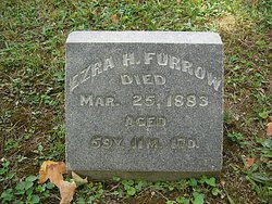

Ezra H Furrow
| Birth | : | 8 Apr 1823 Ohio, USA |
| Death | : | 25 Mar 1883 Champaign County, Ohio, USA |
| Burial | : | St. Thomas Rest Park, Crows Nest, North Sydney Council, Australia |
| Coordinate | : | -33.8244490, 151.2063050 |
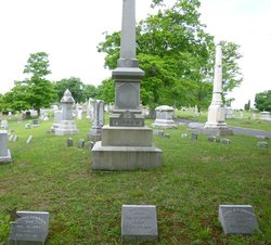
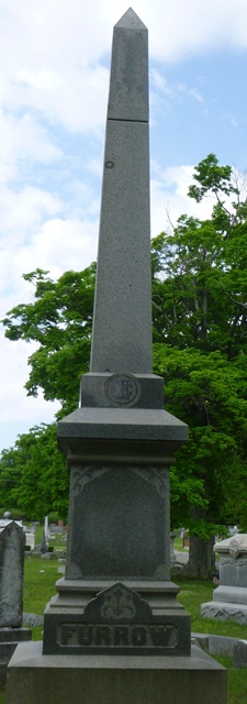
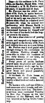
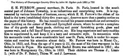
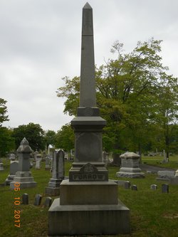
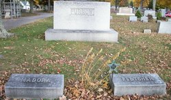
| Description | : | Inscription: Aged 59y, 11m, 17d 1881 Champaign Co, OH EH FURROW, general merchant, St Paris. St Paris located in the south central part of Johnson Township is an industrious and enterprising town. It is represented by various branches of business among which EH Furrow's the oldest of its kind in the town (established thirty-five years ago) deserves more than a passing notice on the pages of this history. He has recently erected his present commodious and attractive store building on the corner of Main and Springfield streets where he carries a complete line of dry goods and fancy goods, clothing and... Read More |
frequently asked questions (FAQ):
-
Where is Ezra H Furrow's memorial?
Ezra H Furrow's memorial is located at: St. Thomas Rest Park, Crows Nest, North Sydney Council, Australia.
-
When did Ezra H Furrow death?
Ezra H Furrow death on 25 Mar 1883 in Champaign County, Ohio, USA
-
Where are the coordinates of the Ezra H Furrow's memorial?
Latitude: -33.8244490
Longitude: 151.2063050
Family Members:
Parent
Spouse
Siblings
Children


Flowers:


Nearby Cemetories:
1. St. Thomas Rest Park
Crows Nest, North Sydney Council, Australia
Coordinate: -33.8244490, 151.2063050
2. Mary MacKillop Memorial Chapel
North Sydney, North Sydney Council, Australia
Coordinate: -33.8388250, 151.2049160
3. Gore Hill Cemetery
St Leonards, North Sydney Council, Australia
Coordinate: -33.8229500, 151.1887590
4. St Aidan's Anglican Church
Longueville, Lane Cove Municipality, Australia
Coordinate: -33.8281510, 151.1709560
5. Rawson Park
Mosman, Mosman Municipality, Australia
Coordinate: -33.8350640, 151.2504980
6. Garden Island
Potts Point, City of Sydney, Australia
Coordinate: -33.8613635, 151.2280308
7. Royal Botanic Gardens
Sydney, City of Sydney, Australia
Coordinate: -33.8647440, 151.2170610
8. Parish Church of Saint James
Sydney, City of Sydney, Australia
Coordinate: -33.8693760, 151.2111540
9. Saint Mary's Cathedral
Sydney, City of Sydney, Australia
Coordinate: -33.8708540, 151.2135820
10. Old Sydney Burial Ground
Sydney, City of Sydney, Australia
Coordinate: -33.8731750, 151.2063850
11. Northern Suburbs Memorial Gardens and Crematorium
North Ryde, Ryde City, Australia
Coordinate: -33.7954460, 151.1511550
12. Devonshire Street Cemetery (Defunct)
Sydney, City of Sydney, Australia
Coordinate: -33.8828080, 151.2066180
13. Macquarie Park Cemetery and Crematorium
North Ryde, Ryde City, Australia
Coordinate: -33.7937180, 151.1420060
14. Gladesville Asylum Cemetery
Gladesville, Hunter's Hill Municipality, Australia
Coordinate: -33.8393010, 151.1342490
15. Manly Cemetery
Manly, Northern Beaches Council, Australia
Coordinate: -33.7922700, 151.2715000
16. Pioneers Memorial Park
Leichhardt, Inner West Council, Australia
Coordinate: -33.8780800, 151.1575000
17. Field of Mars Cemetery
East Ryde, Ryde City, Australia
Coordinate: -33.8120030, 151.1246480
18. Balmain Catholic Cemetery (Defunct)
Leichhardt, Inner West Council, Australia
Coordinate: -33.8797270, 151.1523730
19. Camperdown Cemetery
Newtown, City of Sydney, Australia
Coordinate: -33.8942220, 151.1804900
20. Sydney North Head Quarantine Cemetery
Manly, Northern Beaches Council, Australia
Coordinate: -33.8177130, 151.2947000
21. St Charles Borromeo Cemetery
Ryde, Ryde City, Australia
Coordinate: -33.8188360, 151.1146200
22. St Luke's Anglican Church
Enmore, Inner West Council, Australia
Coordinate: -33.8989218, 151.1700724
23. Ryde Baptist Graveyard
Ryde, Ryde City, Australia
Coordinate: -33.8062930, 151.1119180
24. St. John's Anglican Church Cemetery
Gordon, Ku-ring-gai Council, Australia
Coordinate: -33.7571060, 151.1519580