
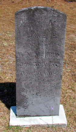
Fannie E. Hough Mangum
| Birth | : | 30 Jan 1858 Chesterfield County, South Carolina, USA |
| Death | : | 30 Nov 1918 Chesterfield County, South Carolina, USA |
| Burial | : | Rest Lawn Memorial Cemetery, Portales, Roosevelt County, USA |
| Coordinate | : | 34.1342010, -103.3347015 |
| Inscription | : | Wife of W.M. Mangum |
| Description | : | * * * * Fannie E Mangum United States Census, 1900 Name: Fannie E Mangum Event Type: Census Event Year: 1900 Event Place: Old Store Township (south part), Chesterfield, South Carolina, United States Gender: Female Age: 43 Marital Status: Married Race: White Race (Original): W Relationship to Head of Household: Wife Relationship to Head of Household (Original): Wife Number of Living Children: 2 Years Married: 22 Birth Date: Jan 1857 Birthplace: South Carolina Marriage Year (Estimated): 1878 Father's Birthplace: South Carolina Mother's Birthplace: South Carolina Mother of how many children: 5 Household Role Sex Age Birthplace William M... Read More |
frequently asked questions (FAQ):
-
Where is Fannie E. Hough Mangum's memorial?
Fannie E. Hough Mangum's memorial is located at: Rest Lawn Memorial Cemetery, Portales, Roosevelt County, USA.
-
When did Fannie E. Hough Mangum death?
Fannie E. Hough Mangum death on 30 Nov 1918 in Chesterfield County, South Carolina, USA
-
Where are the coordinates of the Fannie E. Hough Mangum's memorial?
Latitude: 34.1342010
Longitude: -103.3347015
Family Members:
Parent
Spouse

Siblings
Children
Flowers:


Nearby Cemetories:
1. Rest Lawn Memorial Cemetery
Portales, Roosevelt County, USA
Coordinate: 34.1342010, -103.3347015
2. Portales Cemetery
Portales, Roosevelt County, USA
Coordinate: 34.1860500, -103.3199200
3. Eiland Cemetery
Roosevelt County, USA
Coordinate: 34.1169014, -103.1949997
4. Mount Zion Cemetery
Dora, Roosevelt County, USA
Coordinate: 33.9824982, -103.3268967
5. Bethel Cemetery
Roosevelt County, USA
Coordinate: 34.2146988, -103.4961014
6. Arch Cemetery
Roosevelt County, USA
Coordinate: 34.1133003, -103.1418991
7. Floyd Cemetery
Floyd, Roosevelt County, USA
Coordinate: 34.2141991, -103.5800018
8. Inez Cemetery
Inez, Roosevelt County, USA
Coordinate: 33.9667015, -103.1433029
9. Longs Cemetery
Portales, Roosevelt County, USA
Coordinate: 33.9239006, -103.2110977
10. Upton Cemetery
Upton, Roosevelt County, USA
Coordinate: 34.1553001, -103.6524963
11. Black Tower Cemetery
Curry County, USA
Coordinate: 34.4087510, -103.3365440
12. Mission Garden of Memories Cemetery
Clovis, Curry County, USA
Coordinate: 34.4049263, -103.2436752
13. Richland Cemetery
Roosevelt County, USA
Coordinate: 33.8288994, -103.2835999
14. Elida Cemetery
Elida, Roosevelt County, USA
Coordinate: 33.9645996, -103.6491013
15. Roebuck Cemetery
Roosevelt County, USA
Coordinate: 33.9091440, -103.0740910
16. Texico Cemetery
Texico, Curry County, USA
Coordinate: 34.3758011, -103.0849991
17. Lawn Haven Memorial Gardens Cemetery
Clovis, Curry County, USA
Coordinate: 34.4333000, -103.1856003
18. Causey Cemetery
Causey, Roosevelt County, USA
Coordinate: 33.8507996, -103.1418991
19. West Camp Cemetery
Bailey County, USA
Coordinate: 34.2811012, -102.9757996
20. New Hope Cemetery
Portales, Roosevelt County, USA
Coordinate: 33.7817001, -103.3747025
21. Ingram Cemetery
Roosevelt County, USA
Coordinate: 34.1114006, -103.7632980
22. Reid Cemetery
Ranchvale, Curry County, USA
Coordinate: 34.4937440, -103.3188840
23. Memorial Cemetery
Melrose, Curry County, USA
Coordinate: 34.4307251, -103.6171112
24. Benson Cemetery
Roosevelt County, USA
Coordinate: 34.2002983, -103.7897034