
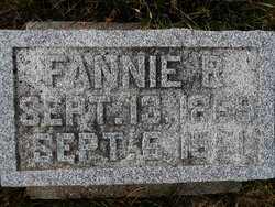

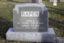
Fannie Mae Raper Davis
| Birth | : | 13 Sep 1859 Linton, Greene County, Indiana, USA |
| Death | : | 5 Sep 1951 Portland, Multnomah County, Oregon, USA |
| Burial | : | Pawnee City Cemetery, Pawnee City, Pawnee County, USA |
| Coordinate | : | 40.1109009, -96.1608810 |
| Plot | : | Hazel Cem. S 1/2 26- 10 |
| Description | : | OBITUARY-THE PAWNEE REBUBLICAN At the Pawnee City cemetery on Monday, Sept. 10th took place graveside services for the burial of Mrs. Fannie Raper Davis, who passed away at her home in Portland, Ore. Sept. 5, the body being brought here by her daughters, Miss Celia Davis of Portland, and Mrs. Ellis A. Johnson of Seattle, following services that were held in the First Christian church in the former city on Sept. 7. She would have been 92 years of age on Sept. 13. Fannie Raper Davis was a pioneer of Pawnee City, being brought to this city by her parents, Mr. and... Read More |
frequently asked questions (FAQ):
-
Where is Fannie Mae Raper Davis's memorial?
Fannie Mae Raper Davis's memorial is located at: Pawnee City Cemetery, Pawnee City, Pawnee County, USA.
-
When did Fannie Mae Raper Davis death?
Fannie Mae Raper Davis death on 5 Sep 1951 in Portland, Multnomah County, Oregon, USA
-
Where are the coordinates of the Fannie Mae Raper Davis's memorial?
Latitude: 40.1109009
Longitude: -96.1608810
Family Members:
Parent
Spouse
Siblings
Children
Flowers:


Nearby Cemetories:
1. Pawnee City Cemetery
Pawnee City, Pawnee County, USA
Coordinate: 40.1109009, -96.1608810
2. East Amish Cemetery
Table Rock, Pawnee County, USA
Coordinate: 40.1310000, -96.0854000
3. Evergreen Cemetery
Pawnee County, USA
Coordinate: 40.0485992, -96.1417007
4. Pleasant Valley Cemetery
Pawnee County, USA
Coordinate: 40.0299988, -96.1554794
5. Table Rock Cemetery
Table Rock, Pawnee County, USA
Coordinate: 40.1791400, -96.1037400
6. Prairie Star Pioneer Cemetery
Du Bois, Pawnee County, USA
Coordinate: 40.0293000, -96.1041000
7. Beranek Cemetery
Table Rock, Pawnee County, USA
Coordinate: 40.2042007, -96.1607971
8. Pleasant Ridge Cemetery
Du Bois, Pawnee County, USA
Coordinate: 40.0156000, -96.1494000
9. West Branch Cemetery
Pawnee County, USA
Coordinate: 40.0787940, -96.2797160
10. Saint Anthonys Cemetery
Steinauer, Pawnee County, USA
Coordinate: 40.2075005, -96.2189026
11. Johnson Creek Cemetery
Pawnee City, Pawnee County, USA
Coordinate: 40.0270000, -96.2465000
12. Clear Creek Cemetery
Table Rock, Pawnee County, USA
Coordinate: 40.2193985, -96.1391983
13. Bohemian Cemetery
Table Rock, Pawnee County, USA
Coordinate: 40.1786003, -96.0374985
14. Saint Peters Evangelican Cemetery
Du Bois, Pawnee County, USA
Coordinate: 40.0010000, -96.1095000
15. Dry Branch Pioneer Cemetery
Richardson County, USA
Coordinate: 40.1292000, -96.0100021
16. DuBois Cemetery
Du Bois, Pawnee County, USA
Coordinate: 40.0231018, -96.0488968
17. Bohemian Cemetery
Richardson County, USA
Coordinate: 40.1175003, -95.9955978
18. Saint Johns Cemetery
Table Rock, Pawnee County, USA
Coordinate: 40.2148000, -96.0657000
19. Salems Cemetery
Steinauer, Pawnee County, USA
Coordinate: 40.2166000, -96.2555000
20. McCaffrey Cemetery
Nemaha County, USA
Coordinate: 39.9827100, -96.1474500
21. Madden Cemetery
Axtell, Marshall County, USA
Coordinate: 39.9866800, -96.2490300
22. Friedens United Church of Christ Cemetery
Bern, Nemaha County, USA
Coordinate: 39.9929008, -96.0529480
23. Saint Peters Lutheran Church Cemetery
Steinauer, Pawnee County, USA
Coordinate: 40.2555000, -96.1801000
24. Cincinnati Cemetery
Du Bois, Pawnee County, USA
Coordinate: 40.0042000, -96.0274963