
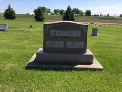
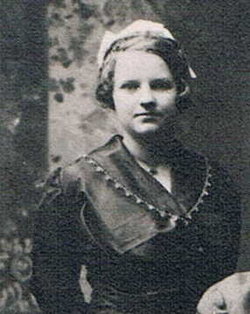
Fern Alvina Marting Schievelbein
| Birth | : | 21 Jan 1930 |
| Death | : | 2 Feb 2015 |
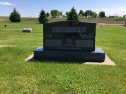
| Burial | : | National Cemetery, National, Clayton County, USA |
| Coordinate | : | 42.9536018, -91.2902985 |
| Description | : | She was the daughter of Vern and Hilda (Dettman) Marting, was born January 21, 1930 in Farmersburg township, Clayton County. She was baptized on April 13, 1930 at St. Peters Lutheran Church, National, Iowa by Pastor G. Bunge and was confirmed on June 18, 1944 at St. John Lutheran Church, Farmerburg by Pastor H. Adix. Fern attended Pioneer Country School near Farmersburg through the eighth grade and graduated from Monona High School in 1947. After graduation she was a waitress in Postville and a self-employed seamstress. On November 19, 1950 she was united in marriage to Lendall Arno Schievelbein at Zion... Read More |
frequently asked questions (FAQ):
-
Where is Fern Alvina Marting Schievelbein's memorial?
Fern Alvina Marting Schievelbein's memorial is located at: National Cemetery, National, Clayton County, USA.
-
When did Fern Alvina Marting Schievelbein death?
Fern Alvina Marting Schievelbein death on 2 Feb 2015 in
-
Where are the coordinates of the Fern Alvina Marting Schievelbein's memorial?
Latitude: 42.9536018
Longitude: -91.2902985
Family Members:
Parent
Flowers:


Nearby Cemetories:
1. National Cemetery
National, Clayton County, USA
Coordinate: 42.9536018, -91.2902985
2. Giard Cemetery
Farmersburg, Clayton County, USA
Coordinate: 42.9933014, -91.3080978
3. Bismark Cemetery
Farmersburg, Clayton County, USA
Coordinate: 42.9790000, -91.3500000
4. Farmersburg-Wagner Cemetery
Farmersburg, Clayton County, USA
Coordinate: 42.9481010, -91.3700027
5. Eastman Cemetery
McGregor, Clayton County, USA
Coordinate: 43.0010000, -91.2190000
6. Clayton Center Cemetery
Clayton Center, Clayton County, USA
Coordinate: 42.8841705, -91.3225021
7. Zion Lutheran Cemetery
Clayton Center, Clayton County, USA
Coordinate: 42.8841705, -91.3249969
8. County Home Cemetery
Clayton Center, Clayton County, USA
Coordinate: 42.8916702, -91.3499985
9. Railroad Employee Cemetery
Giard, Clayton County, USA
Coordinate: 43.0305395, -91.3140229
10. Norwegian Church Cemetery
McGregor, Clayton County, USA
Coordinate: 42.9644400, -91.1764100
11. First Evangelical Lutheran Church Cemetery
McGregor, Clayton County, USA
Coordinate: 42.9718000, -91.1760000
12. Colony Catholic Cemetery (Defunct)
Read Township, Clayton County, USA
Coordinate: 42.8830000, -91.3580000
13. Moody Cemetery
McGregor, Clayton County, USA
Coordinate: 43.0030594, -91.1886063
14. Buell Park Cemetery
Mendon Township, Clayton County, USA
Coordinate: 43.0168226, -91.1999590
15. Garnavillo Community Cemetery
Garnavillo, Clayton County, USA
Coordinate: 42.8656000, -91.2422100
16. Garnavillo Cemetery
Garnavillo, Clayton County, USA
Coordinate: 42.8660300, -91.2390100
17. Saint Joseph Cemetery
Garnavillo, Clayton County, USA
Coordinate: 42.8628006, -91.2502975
18. Walton Cemetery
McGregor, Clayton County, USA
Coordinate: 43.0216270, -91.1909350
19. Gooding Cemetery
Wagner Township, Clayton County, USA
Coordinate: 42.9869490, -91.4191570
20. Pleasant Grove Cemetery
McGregor, Clayton County, USA
Coordinate: 43.0266991, -91.1949997
21. Saint Marys Catholic Church Cemetery
McGregor, Clayton County, USA
Coordinate: 43.0213735, -91.1834632
22. Norway Lutheran Church Cemetery
Saint Olaf, Clayton County, USA
Coordinate: 42.9352798, -91.4302826
23. Clayton Cemetery
Clayton, Clayton County, USA
Coordinate: 42.9043999, -91.1641998
24. Saint Wenceslaus Cemetery
McGregor, Clayton County, USA
Coordinate: 43.0593987, -91.3142014