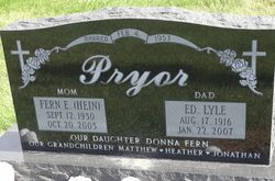
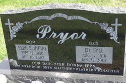
Fern Ellen Hein Pryor
| Birth | : | 12 Sep 1930 Dunlap, Harrison County, Iowa, USA |
| Death | : | 20 Oct 2005 Dunlap, Harrison County, Iowa, USA |
| Burial | : | Good Shepherd Catholic Cemetery, Lancaster, Los Angeles County, USA |
| Coordinate | : | 34.6656400, -118.2541300 |
| Plot | : | Block 10 |
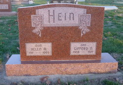
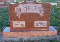
| Description | : | Fern Ellen (Hein) Pryor was born September 12, 1930, to Gifford and Helen (Willis) Hein in Rural Dunlap, Iowa. Fern attended country school until she was a freshman and graduated from Dunlap High School in 1950. Fern married Edward "Lyle" Pryor of February 4, 1953. The couple was blessed with one daughter, Donna. The couple farmed until they moved to Grand Island, Nebraska where they managed the Pine Crest Motel. After returning to the Dunlap area, they farmed until their retirement. Fern was actively engaged in farming with Lyle. Fern loved to crochet, garden, can, and sew. She was an active... Read More |
frequently asked questions (FAQ):
-
Where is Fern Ellen Hein Pryor's memorial?
Fern Ellen Hein Pryor's memorial is located at: Good Shepherd Catholic Cemetery, Lancaster, Los Angeles County, USA.
-
When did Fern Ellen Hein Pryor death?
Fern Ellen Hein Pryor death on 20 Oct 2005 in Dunlap, Harrison County, Iowa, USA
-
Where are the coordinates of the Fern Ellen Hein Pryor's memorial?
Latitude: 34.6656400
Longitude: -118.2541300
Family Members:
Parent
Spouse
Siblings
Flowers:
Nearby Cemetories:
1. Good Shepherd Catholic Cemetery
Lancaster, Los Angeles County, USA
Coordinate: 34.6656400, -118.2541300
2. Lancaster Cemetery
Lancaster, Los Angeles County, USA
Coordinate: 34.6977806, -118.1286087
3. Joshua Memorial Park
Lancaster, Los Angeles County, USA
Coordinate: 34.6958008, -118.1141968
4. Palmdale Cemetery
Palmdale, Los Angeles County, USA
Coordinate: 34.5592003, -118.0916977
5. Desert Lawn Memorial Park
Palmdale, Los Angeles County, USA
Coordinate: 34.5525890, -118.0900880
6. Vasquez Rocks Natural Area County Park Burial Site
Agua Dulce, Los Angeles County, USA
Coordinate: 34.4886600, -118.3214500
7. Islamic Cemetery and Masjid
Rosamond, Kern County, USA
Coordinate: 34.8385340, -118.3402240
8. Acton Community Cemetery
Acton, Los Angeles County, USA
Coordinate: 34.4791985, -118.2007980
9. Mount Gleason Ranch Cemetery
Acton, Los Angeles County, USA
Coordinate: 34.4410480, -118.1980720
10. Mitchell-Dyer Family Cemetery
Santa Clarita, Los Angeles County, USA
Coordinate: 34.4210200, -118.4309600
11. Ruiz-Perea Family Cemetery
Santa Clarita, Los Angeles County, USA
Coordinate: 34.4889170, -118.5458940
12. Sand Canyon Ranch Burial Site
Santa Clarita, Los Angeles County, USA
Coordinate: 34.3766880, -118.4105940
13. Melody Ranch Burial Ground
Newhall, Los Angeles County, USA
Coordinate: 34.3833080, -118.5102620
14. Loomis Family Cemetery
Mount Wilson, Los Angeles County, USA
Coordinate: 34.3470200, -118.0488700
15. William S Hart Estate Burial Site
Newhall, Los Angeles County, USA
Coordinate: 34.3746600, -118.5249600
16. Eternal Valley Memorial Park
Newhall, Los Angeles County, USA
Coordinate: 34.3625336, -118.5077057
17. Trier-Pfalzel
Pfalzel, Stadtkreis Trier, Germany
Coordinate: 34.9245895, -117.9339504
18. Glen Haven Memorial Park
Sylmar, Los Angeles County, USA
Coordinate: 34.3085130, -118.3768380
19. Sholom Memorial Park
Sylmar, Los Angeles County, USA
Coordinate: 34.3051630, -118.3763500
20. Pioneer Memorial Cemetery
Sylmar, Los Angeles County, USA
Coordinate: 34.3209305, -118.4481125
21. Saint Andrews Abbey Cemetery
Valyermo, Los Angeles County, USA
Coordinate: 34.4521217, -117.8681335
22. Colby Ranch Cemetery
Palmdale, Los Angeles County, USA
Coordinate: 34.2986200, -118.1115100
23. James Foley Gravesite
Tehachapi, Kern County, USA
Coordinate: 35.0509590, -118.3561170
24. Mojave Cemetery
Mojave, Kern County, USA
Coordinate: 35.0550117, -118.1694565

