
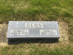

Flora Katherine Haltmeyer Dehn
| Birth | : | 20 Mar 1870 Minnesota, USA |
| Death | : | 30 Apr 1947 Clark County, South Dakota, USA |
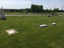
| Burial | : | Garnavillo Community Cemetery, Garnavillo, Clayton County, USA |
| Coordinate | : | 42.8656000, -91.2422100 |
| Plot | : | Bl 2-35-9 |
| Description | : | Bur:5-5-1947 Huronite and Daily Plainsman, Huron, SD, Thursday, May 1, 1947, Pg. 2, Col. 6. Clark, MAY 1.-Mrs. Flora Katherine Dehn, 77, died last evening at the home of her daughter, Mrs. Henry Ramsey, in Mt. Pleasant Township. Mrs. Dehn had made her home with her daughter for some time and had been ill with heart trouble the past several months. The body lies in state at the Nash Funeral home until Friday when services will be held there and the body taken to Waterloo, IA., for burial. Transcribed by: Find A Grave contributor reo |
frequently asked questions (FAQ):
-
Where is Flora Katherine Haltmeyer Dehn's memorial?
Flora Katherine Haltmeyer Dehn's memorial is located at: Garnavillo Community Cemetery, Garnavillo, Clayton County, USA.
-
When did Flora Katherine Haltmeyer Dehn death?
Flora Katherine Haltmeyer Dehn death on 30 Apr 1947 in Clark County, South Dakota, USA
-
Where are the coordinates of the Flora Katherine Haltmeyer Dehn's memorial?
Latitude: 42.8656000
Longitude: -91.2422100
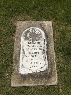
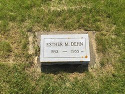
Family Members:
Parent

Spouse

Children

Flowers:


Nearby Cemetories:
1. Garnavillo Community Cemetery
Garnavillo, Clayton County, USA
Coordinate: 42.8656000, -91.2422100
2. Garnavillo Cemetery
Garnavillo, Clayton County, USA
Coordinate: 42.8660300, -91.2390100
3. Saint Joseph Cemetery
Garnavillo, Clayton County, USA
Coordinate: 42.8628006, -91.2502975
4. McClelland Cemetery
Garnavillo, Clayton County, USA
Coordinate: 42.8249879, -91.2084641
5. Pioneer Rock Cemetery
Ceres, Clayton County, USA
Coordinate: 42.8230591, -91.1863937
6. Clayton Center Cemetery
Clayton Center, Clayton County, USA
Coordinate: 42.8841705, -91.3225021
7. Zion Lutheran Cemetery
Clayton Center, Clayton County, USA
Coordinate: 42.8841705, -91.3249969
8. Clayton Cemetery
Clayton, Clayton County, USA
Coordinate: 42.9043999, -91.1641998
9. Tangeman Family Cemetery
Garnavillo, Clayton County, USA
Coordinate: 42.8580000, -91.1420000
10. Saint Michael Cemetery
Clayton County, USA
Coordinate: 42.8055992, -91.1802979
11. County Home Cemetery
Clayton Center, Clayton County, USA
Coordinate: 42.8916702, -91.3499985
12. Krumm Cemetery
Garber, Clayton County, USA
Coordinate: 42.7913760, -91.3023559
13. Colony Catholic Cemetery (Defunct)
Read Township, Clayton County, USA
Coordinate: 42.8830000, -91.3580000
14. Borcherding Cemetery
Jefferson Township, Clayton County, USA
Coordinate: 42.8182983, -91.1414032
15. National Cemetery
National, Clayton County, USA
Coordinate: 42.9536018, -91.2902985
16. Storck Cemetery
Guttenberg, Clayton County, USA
Coordinate: 42.7694335, -91.1834638
17. Harford Cemetery
Wyalusing, Grant County, USA
Coordinate: 42.9401000, -91.1401800
18. Saint Paula Cemetery
Osterdock, Clayton County, USA
Coordinate: 42.7635994, -91.1992035
19. Meenan Cemetery
Communia, Clayton County, USA
Coordinate: 42.7999862, -91.3584693
20. Norwegian Church Cemetery
McGregor, Clayton County, USA
Coordinate: 42.9644400, -91.1764100
21. Old Garber Cemetery
Garber, Clayton County, USA
Coordinate: 42.7560005, -91.2580032
22. Elkader Cemetery
Elkader, Clayton County, USA
Coordinate: 42.8541718, -91.4000015
23. Bagley Cemetery
Bagley, Grant County, USA
Coordinate: 42.9019012, -91.0907974
24. First Evangelical Lutheran Church Cemetery
McGregor, Clayton County, USA
Coordinate: 42.9718000, -91.1760000