

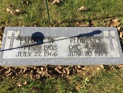
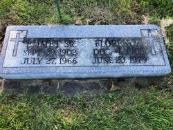
Florence Duwe Rademacher
| Birth | : | 4 Dec 1905 Guttenberg, Clayton County, Iowa, USA |
| Death | : | 20 Jun 1979 Guttenberg, Clayton County, Iowa, USA |
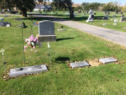
| Burial | : | Garnavillo Community Cemetery, Garnavillo, Clayton County, USA |
| Coordinate | : | 42.8656000, -91.2422100 |
| Plot | : | Block 6 Lot 5 Grave 4 |
| Description | : | The Guttenberg Press, June 1979 MRS. RADEMACHER RITES HELD Florence H. Rademacher, 73, died at 8:38 a.m. on June 20, 1979, at Guttenberg Municipal Hospital after a brief illness. Services were held at 11 a.m. Friday, June 22, at St. Paul Lutheran Church in Garnavillo with the Rev. L.C. Urlaub officiating. Burial was in the City Cemetery in Garnavillo. Pallbearers were Arnold Roggman, Walter Wright, Richard Thein, Allen Werger, Alvin Bierbaum and Frank Baxter. Florence H. Rademacher was born Dec. 4, 1905 at Guttenberg. She was the daughter of Dietrich Duwe and Elizabeth Rethwisch. ... Read More |
frequently asked questions (FAQ):
-
Where is Florence Duwe Rademacher's memorial?
Florence Duwe Rademacher's memorial is located at: Garnavillo Community Cemetery, Garnavillo, Clayton County, USA.
-
When did Florence Duwe Rademacher death?
Florence Duwe Rademacher death on 20 Jun 1979 in Guttenberg, Clayton County, Iowa, USA
-
Where are the coordinates of the Florence Duwe Rademacher's memorial?
Latitude: 42.8656000
Longitude: -91.2422100
Family Members:
Parent

Spouse
Siblings
Children
Flowers:


Nearby Cemetories:
1. Garnavillo Community Cemetery
Garnavillo, Clayton County, USA
Coordinate: 42.8656000, -91.2422100
2. Garnavillo Cemetery
Garnavillo, Clayton County, USA
Coordinate: 42.8660300, -91.2390100
3. Saint Joseph Cemetery
Garnavillo, Clayton County, USA
Coordinate: 42.8628006, -91.2502975
4. McClelland Cemetery
Garnavillo, Clayton County, USA
Coordinate: 42.8249879, -91.2084641
5. Pioneer Rock Cemetery
Ceres, Clayton County, USA
Coordinate: 42.8230591, -91.1863937
6. Clayton Center Cemetery
Clayton Center, Clayton County, USA
Coordinate: 42.8841705, -91.3225021
7. Zion Lutheran Cemetery
Clayton Center, Clayton County, USA
Coordinate: 42.8841705, -91.3249969
8. Clayton Cemetery
Clayton, Clayton County, USA
Coordinate: 42.9043999, -91.1641998
9. Tangeman Family Cemetery
Garnavillo, Clayton County, USA
Coordinate: 42.8580000, -91.1420000
10. Saint Michael Cemetery
Clayton County, USA
Coordinate: 42.8055992, -91.1802979
11. County Home Cemetery
Clayton Center, Clayton County, USA
Coordinate: 42.8916702, -91.3499985
12. Krumm Cemetery
Garber, Clayton County, USA
Coordinate: 42.7913760, -91.3023559
13. Colony Catholic Cemetery (Defunct)
Read Township, Clayton County, USA
Coordinate: 42.8830000, -91.3580000
14. Borcherding Cemetery
Jefferson Township, Clayton County, USA
Coordinate: 42.8182983, -91.1414032
15. National Cemetery
National, Clayton County, USA
Coordinate: 42.9536018, -91.2902985
16. Storck Cemetery
Guttenberg, Clayton County, USA
Coordinate: 42.7694335, -91.1834638
17. Harford Cemetery
Wyalusing, Grant County, USA
Coordinate: 42.9401000, -91.1401800
18. Saint Paula Cemetery
Osterdock, Clayton County, USA
Coordinate: 42.7635994, -91.1992035
19. Meenan Cemetery
Communia, Clayton County, USA
Coordinate: 42.7999862, -91.3584693
20. Norwegian Church Cemetery
McGregor, Clayton County, USA
Coordinate: 42.9644400, -91.1764100
21. Old Garber Cemetery
Garber, Clayton County, USA
Coordinate: 42.7560005, -91.2580032
22. Elkader Cemetery
Elkader, Clayton County, USA
Coordinate: 42.8541718, -91.4000015
23. Bagley Cemetery
Bagley, Grant County, USA
Coordinate: 42.9019012, -91.0907974
24. First Evangelical Lutheran Church Cemetery
McGregor, Clayton County, USA
Coordinate: 42.9718000, -91.1760000