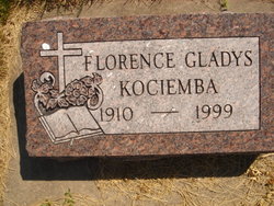
Florence Gladys Otlewski Kociemba
| Birth | : | 3 Jun 1910 Loup City, Sherman County, Nebraska, USA |
| Death | : | 20 Jan 1999 Grand Island, Hall County, Nebraska, USA |
| Burial | : | St Mary Northgate Cemetery, Canterbury, City of Canterbury, England |
| Coordinate | : | 51.2811320, 1.0859300 |
| Description | : | Thanks to contributor #48763187 WOOD RIVER - Florence Gladys Kociemba, 88, of Wood River, formerly of Ravenna, died Wednesday, Jan. 20, 1999, at St. Francis Medical Center in Grand Island. Services will be at 10 a.m. Monday at St. Mary's Catholic Church in Wood River. The Rev. Ray Kosmicki will officiate. Burial will be at 2 p.m. Monday in Evergreen Cemetery in Loup City. Visitations will be from 5 to 8 p.m., with a 6:30 p.m. rosary, Sunday at Apfel Funeral Home in Wood River. Memorials are suggested to the St. Francis Medical Center Skilled Care Unit... Read More |
frequently asked questions (FAQ):
-
Where is Florence Gladys Otlewski Kociemba's memorial?
Florence Gladys Otlewski Kociemba's memorial is located at: St Mary Northgate Cemetery, Canterbury, City of Canterbury, England.
-
When did Florence Gladys Otlewski Kociemba death?
Florence Gladys Otlewski Kociemba death on 20 Jan 1999 in Grand Island, Hall County, Nebraska, USA
-
Where are the coordinates of the Florence Gladys Otlewski Kociemba's memorial?
Latitude: 51.2811320
Longitude: 1.0859300
Family Members:
Parent
Spouse
Siblings
Children
Flowers:
Nearby Cemetories:
1. St Mary Northgate Cemetery
Canterbury, City of Canterbury, England
Coordinate: 51.2811320, 1.0859300
2. St Gregory Churchyard
Canterbury, City of Canterbury, England
Coordinate: 51.2816050, 1.0887840
3. St Gregory's Priory (defunct)
Canterbury, City of Canterbury, England
Coordinate: 51.2831127, 1.0855358
4. Canterbury Cathedral
Canterbury, City of Canterbury, England
Coordinate: 51.2796936, 1.0826840
5. St. John the Baptist Hospital Chapelyard
Canterbury, City of Canterbury, England
Coordinate: 51.2832713, 1.0837677
6. St Paul Without the Walls
Canterbury, City of Canterbury, England
Coordinate: 51.2779380, 1.0853180
7. St Mary Magdalene Church Demolished
Canterbury, City of Canterbury, England
Coordinate: 51.2784510, 1.0830170
8. St Augustine Abbey Ruins
Canterbury, City of Canterbury, England
Coordinate: 51.2781280, 1.0882060
9. St George's Church Demolished
Canterbury, City of Canterbury, England
Coordinate: 51.2773770, 1.0827380
10. All Saints Church Demolished
Canterbury, City of Canterbury, England
Coordinate: 51.2802800, 1.0783450
11. St Mary Breadman Church Demolished
Canterbury, City of Canterbury, England
Coordinate: 51.2798870, 1.0784520
12. St Margaret's Churchyard
Canterbury, City of Canterbury, England
Coordinate: 51.2781780, 1.0795840
13. St Mary Bredin Old Church (Defunct)
Canterbury, City of Canterbury, England
Coordinate: 51.2773455, 1.0803962
14. St Peter the Apostle Churchyard
Canterbury, City of Canterbury, England
Coordinate: 51.2807260, 1.0775370
15. St Peters Methodist Church
Canterbury, City of Canterbury, England
Coordinate: 51.2801720, 1.0771480
16. St Martin Churchyard
Canterbury, City of Canterbury, England
Coordinate: 51.2780170, 1.0937160
17. Holy Cross Church
Canterbury, City of Canterbury, England
Coordinate: 51.2811350, 1.0755710
18. Westgate Gardens
Canterbury, City of Canterbury, England
Coordinate: 51.2805250, 1.0745040
19. Dane John Gardens
Canterbury, City of Canterbury, England
Coordinate: 51.2754210, 1.0780390
20. St Mary de Castro Churchyard
Canterbury, City of Canterbury, England
Coordinate: 51.2762400, 1.0766820
21. St. Mildred with St. Mary de Castro Church
Canterbury, City of Canterbury, England
Coordinate: 51.2764810, 1.0743320
22. St. Dunstan Churchyard
Canterbury, City of Canterbury, England
Coordinate: 51.2836820, 1.0707800
23. Canterbury Jewish Cemetery
Canterbury, City of Canterbury, England
Coordinate: 51.2846135, 1.0706660
24. Canterbury City Cemetery
Canterbury, City of Canterbury, England
Coordinate: 51.2843285, 1.0637640

