
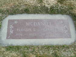
Flossie Stephen Griggs McDaniel
| Birth | : | 21 Dec 1896 Fulton, Callaway County, Missouri, USA |
| Death | : | 3 Jul 1973 Soap Lake, Grant County, Washington, USA |
| Burial | : | Chelan Fraternal Cemetery, Chelan, Chelan County, USA |
| Coordinate | : | 47.8502998, -120.0081024 |
| Plot | : | North Frathernal Row62 STBLK61 LS2 |
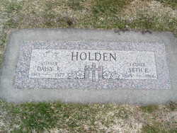
| Inscription | : | George A McDaniel |
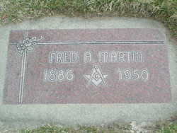
| Description | : | m: Fred Martin 1921 m: Mr. Cosens m: George McDaniels 1941 Flossie S. McDaniels, 76, Soap Lake, formerly of Manson, died Tuesday evening at Soap Lake following a short illness. She was born on Dec. 21, 1896, at Fulton, Mo. As a child she moved with her parents to North Dakota to live for several years until 1912, when the family moved to Manson. In 1921 she was married to Fred Martin, and later he preceded her in death. In 1941 she was married to George McDaniels at Ellensburg. Following their marriage they made their home in the Methow Valley. For... Read More |
frequently asked questions (FAQ):
-
Where is Flossie Stephen Griggs McDaniel's memorial?
Flossie Stephen Griggs McDaniel's memorial is located at: Chelan Fraternal Cemetery, Chelan, Chelan County, USA.
-
When did Flossie Stephen Griggs McDaniel death?
Flossie Stephen Griggs McDaniel death on 3 Jul 1973 in Soap Lake, Grant County, Washington, USA
-
Where are the coordinates of the Flossie Stephen Griggs McDaniel's memorial?
Latitude: 47.8502998
Longitude: -120.0081024
Family Members:
Parent

Spouse

Siblings

Flowers:


Nearby Cemetories:
1. Chelan Fraternal Cemetery
Chelan, Chelan County, USA
Coordinate: 47.8502998, -120.0081024
2. Mount Olivet Cemetery
Chelan, Chelan County, USA
Coordinate: 47.8451000, -119.9946000
3. Saint Andrews Episcopal Church
Chelan, Chelan County, USA
Coordinate: 47.8397460, -120.0183780
4. Riverview Cemetery
Chelan, Chelan County, USA
Coordinate: 47.8335991, -119.9944000
5. Manson Indian Cemetery
Manson, Chelan County, USA
Coordinate: 47.8800000, -120.1300000
6. Ballard Family Cemetery
Stayman, Chelan County, USA
Coordinate: 47.7811100, -120.1133300
7. Fletcher Cemetery
Douglas County, USA
Coordinate: 47.7430992, -119.9403000
8. Brays Landing Cemetery
Douglas County, USA
Coordinate: 47.7364120, -120.1704660
9. Kummer Cemetery
Waterville, Douglas County, USA
Coordinate: 47.6559000, -120.0332000
10. Packwood Memorial Cemetery
Dyer, Douglas County, USA
Coordinate: 48.0118305, -119.8178880
11. Dick Family Cemetery
Okanogan County, USA
Coordinate: 48.0502700, -119.9241700
12. Miller Family Cemetery
Okanogan County, USA
Coordinate: 48.0530300, -119.9288000
13. Pateros Cemetery
Pateros, Okanogan County, USA
Coordinate: 48.0516600, -119.9097300
14. Waterville Cemetery
Waterville, Douglas County, USA
Coordinate: 47.6418500, -120.0685940
15. Gate of Heaven Catholic Cemetery
Waterville, Douglas County, USA
Coordinate: 47.6382100, -120.0671690
16. Douglas Lutheran Cemetery
Douglas County, USA
Coordinate: 47.6189003, -119.9614029
17. Badger Mountain View Cemetery
Douglas County, USA
Coordinate: 47.6088000, -120.0476000
18. Mansfield Cemetery
Mansfield, Douglas County, USA
Coordinate: 47.8088880, -119.6508330
19. Orondo Community Cemetery
Orondo, Douglas County, USA
Coordinate: 47.6486015, -120.2136002
20. Buckingham Cemetery
Douglas County, USA
Coordinate: 47.8669014, -119.6286011
21. Happy Home Cemetery
Farmer, Douglas County, USA
Coordinate: 47.6268997, -119.8125000
22. Methow Cemetery
Methow, Okanogan County, USA
Coordinate: 48.1102982, -120.0124969
23. Entiat Cemetery
Entiat, Chelan County, USA
Coordinate: 47.6755981, -120.3043976
24. Bridgeport Cemetery
Bridgeport, Douglas County, USA
Coordinate: 48.0050000, -119.6738800