

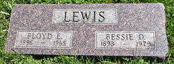
Floyd Earl Lewis
| Birth | : | 20 Jan 1896 Nodaway, Adams County, Iowa, USA |
| Death | : | 7 Dec 1968 Clarinda, Page County, Iowa, USA |
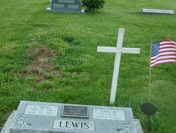
| Burial | : | Woodsdale Memorial Park, Pruntytown, Taylor County, USA |
| Coordinate | : | 39.3408012, -80.0658035 |
| Description | : | [LEWIS, FLOYD EARL] Clarinda Herald Journal (Clarinda, Iowa), Monday, December 9, 1968, p. 12 Floyd Lewis, 72, is heart victim Floyd E Lewis, 72, was stricken with a sudden heart attack about 4:30 p m Saturday and was pronounced dead on arrival at the Clarinda Municipal Hospital a few minutes later. He and his wife had been downtown to the Christmas drawing and the fatal attack struck him as he was getting in his car to go home. He was the son of the late Jesse and Sue Wright Lewis, and was born at Nodaway, Iowa. Much of his... Read More |
frequently asked questions (FAQ):
-
Where is Floyd Earl Lewis's memorial?
Floyd Earl Lewis's memorial is located at: Woodsdale Memorial Park, Pruntytown, Taylor County, USA.
-
When did Floyd Earl Lewis death?
Floyd Earl Lewis death on 7 Dec 1968 in Clarinda, Page County, Iowa, USA
-
Where are the coordinates of the Floyd Earl Lewis's memorial?
Latitude: 39.3408012
Longitude: -80.0658035
Family Members:
Parent

Spouse
Siblings
Children
Flowers:


Nearby Cemetories:
1. West Virginia National Cemetery
Pruntytown, Taylor County, USA
Coordinate: 39.3350190, -80.0730590
2. Warder Cemetery
Pruntytown, Taylor County, USA
Coordinate: 39.3360670, -80.0549330
3. Beulah Cemetery
Pruntytown, Taylor County, USA
Coordinate: 39.3336590, -80.0817140
4. Abram Smith Cemetery
Pruntytown, Taylor County, USA
Coordinate: 39.3314018, -80.0811005
5. Keener Cemetery
Grafton, Taylor County, USA
Coordinate: 39.3502370, -80.0503460
6. Wiseman Cemetery
Pruntytown, Taylor County, USA
Coordinate: 39.3602170, -80.0782840
7. Grafton National Cemetery
Grafton, Taylor County, USA
Coordinate: 39.3350296, -80.0312500
8. Carder Cemetery
Fetterman, Taylor County, USA
Coordinate: 39.3618760, -80.0409150
9. Old Catholic Cemetery
Taylor County, USA
Coordinate: 39.3445200, -80.0243000
10. Gawthrop Cemetery
Pruntytown, Taylor County, USA
Coordinate: 39.3292360, -80.1095210
11. Mount Calvary Catholic Cemetery
Grafton, Taylor County, USA
Coordinate: 39.3492012, -80.0171967
12. Knotts Cemetery
Grafton, Taylor County, USA
Coordinate: 39.3550030, -80.0170860
13. Bluemont Cemetery
Grafton, Taylor County, USA
Coordinate: 39.3446999, -80.0121994
14. Lantz Ford Cemetery
Grafton, Taylor County, USA
Coordinate: 39.3219370, -80.0132820
15. Harmony Grove Cemetery
Grafton, Taylor County, USA
Coordinate: 39.3456001, -80.1267014
16. Reese Cemetery
Grafton, Taylor County, USA
Coordinate: 39.3604990, -80.0068620
17. Brown Cemetery
Taylor County, USA
Coordinate: 39.3841630, -80.0295590
18. Walnut Grove Cemetery
Webster, Taylor County, USA
Coordinate: 39.2813988, -80.0472031
19. Lawler Cemetery
McGee, Taylor County, USA
Coordinate: 39.3845000, -80.1238000
20. Arnold Cemetery
Grafton, Taylor County, USA
Coordinate: 39.2985115, -80.0014712
21. Glady Creek Cemetery
Marion County, USA
Coordinate: 39.4030080, -80.0382530
22. Linn and Hickman Cemetery
Marion County, USA
Coordinate: 39.4007988, -80.0286026
23. Wesley Chapel Cemetery
Grafton, Taylor County, USA
Coordinate: 39.3044014, -79.9922028
24. West Hill Cemetery
Taylor County, USA
Coordinate: 39.2782810, -80.0284830