
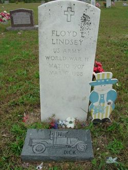
Floyd Lee “Dick” Lindsey
| Birth | : | 10 May 1907 Shannon County, Missouri, USA |
| Death | : | 17 Mar 1988 Poplar Bluff, Butler County, Missouri, USA |
| Burial | : | Agecroft Cemetery and Crematorium, Salford, Metropolitan Borough of Salford, England |
| Coordinate | : | 53.5100250, -2.2940500 |
| Inscription | : | US Army World War II. |
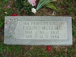
| Description | : | Floyd Lee 'Dick' Lindsey - Born May 10, 1907 in Shannon Co MO, the son of James Rote and Anna Gelolah Perigo Lindsey, and departed this life on March 17, 1988 at the John Pershing Hospital in Poplar Bluff MO at the age of 80 years. He was preceded in death by his parents and five sisters. He is survived by one brother, Ermine Lindsey of Hartford CT; two sisters, Floy Voyles and Cora McGuire, both of Winona MO; and several nieces and nephews. Floyd was the last charter member of the VFW Post #2119 of Winona. Funeral services were... Read More |
frequently asked questions (FAQ):
-
Where is Floyd Lee “Dick” Lindsey's memorial?
Floyd Lee “Dick” Lindsey's memorial is located at: Agecroft Cemetery and Crematorium, Salford, Metropolitan Borough of Salford, England.
-
When did Floyd Lee “Dick” Lindsey death?
Floyd Lee “Dick” Lindsey death on 17 Mar 1988 in Poplar Bluff, Butler County, Missouri, USA
-
Where are the coordinates of the Floyd Lee “Dick” Lindsey's memorial?
Latitude: 53.5100250
Longitude: -2.2940500
Family Members:
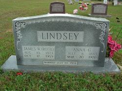
Parent

Siblings
Flowers:


Nearby Cemetories:
1. Agecroft Cemetery and Crematorium
Salford, Metropolitan Borough of Salford, England
Coordinate: 53.5100250, -2.2940500
2. Agecroft Jewish Cemetery
Pendlebury, Metropolitan Borough of Salford, England
Coordinate: 53.5110302, -2.2955830
3. Rainsough Jewish Cemetery
Prestwich, Metropolitan Borough of Bury, England
Coordinate: 53.5185530, -2.2906950
4. St John The Evangelist Churchyard
Pendlebury, Metropolitan Borough of Salford, England
Coordinate: 53.5036200, -2.3088500
5. St Paul's Churchyard
Salford, Metropolitan Borough of Salford, England
Coordinate: 53.5148800, -2.2725500
6. Saint Augustine's Churchyard
Pendlebury, Metropolitan Borough of Salford, England
Coordinate: 53.5107070, -2.3223960
7. St. Thomas' Churchyard
Salford, Metropolitan Borough of Salford, England
Coordinate: 53.4921430, -2.2856130
8. St. Mary the Virgin Churchyard
Prestwich, Metropolitan Borough of Bury, England
Coordinate: 53.5294033, -2.2864891
9. Great Synagogue Cemetery
Prestwich, Metropolitan Borough of Bury, England
Coordinate: 53.5315510, -2.2845730
10. St. Paul's Wesleyan Methodist Churchyard
Swinton, Metropolitan Borough of Salford, England
Coordinate: 53.5133900, -2.3397500
11. St. Peter's Churchyard
Swinton, Metropolitan Borough of Salford, England
Coordinate: 53.5119130, -2.3413860
12. St. Marks' Churchyard
Cheetham Hill, Metropolitan Borough of Manchester, England
Coordinate: 53.5113780, -2.2462660
13. Wesleyan Methodist Cemetery
Crumpsall, Metropolitan Borough of Manchester, England
Coordinate: 53.5142870, -2.2447610
14. Weaste Cemetery
Weaste, Metropolitan Borough of Salford, England
Coordinate: 53.4795227, -2.3017540
15. Swinton Cemetery
Swinton, Metropolitan Borough of Salford, England
Coordinate: 53.5183372, -2.3457739
16. St Anne Churchyard
Clifton, Metropolitan Borough of Salford, England
Coordinate: 53.5277070, -2.3391650
17. Strangeways Prison Cemetery (Defunct)
Manchester, Metropolitan Borough of Manchester, England
Coordinate: 53.4925000, -2.2463890
18. Irwell Street Wesleyan Chapel Cemetery
Salford, Metropolitan Borough of Salford, England
Coordinate: 53.4829750, -2.2587540
19. Manchester Reform Jewish Old Cemetery
Whitefield, Metropolitan Borough of Bury, England
Coordinate: 53.5442728, -2.2918894
20. New Jerusalem Temple Cemetery
Salford, Metropolitan Borough of Salford, England
Coordinate: 53.4827720, -2.2571250
21. St Mary the Virgin Churchyard
Eccles, Metropolitan Borough of Salford, England
Coordinate: 53.4843810, -2.3346810
22. St Luke's Churchyard
Cheetham Hill, Metropolitan Borough of Manchester, England
Coordinate: 53.5041660, -2.2354680
23. Christ Church
Salford, Metropolitan Borough of Salford, England
Coordinate: 53.4864284, -2.2497653
24. St Chad's Churchyard
Cheetham Hill, Metropolitan Borough of Manchester, England
Coordinate: 53.4922100, -2.2400500