
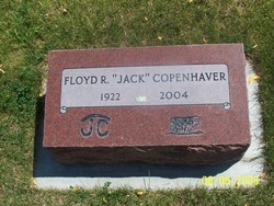
Floyd Ronald “Jack” Copenhaver
| Birth | : | 22 Aug 1922 Wilbur, Lincoln County, Washington, USA |
| Death | : | 8 Mar 2004 Imbler, Union County, Oregon, USA |
| Burial | : | Saint Joseph Catholic Cemetery, Shawnee, Johnson County, USA |
| Coordinate | : | 39.0167700, -94.7228800 |
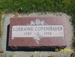
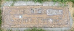
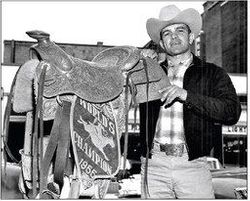
| Description | : | Floyd `Jack' Copenhaver Imbler, Ore. Viewing for Floyd Ronald "Jack" Copenhaver, 81, a former mayor of Wilbur, Wash., will be Friday from 11:30 a.m. to 12:30 p.m. at the Community Presbyterian Church in Wilbur. Graveside service will be at 1 p.m. in the Wilbur Cemetery. Loveland Funeral Chapel is in charge of arrangements. Mr. Copenhaver died Monday. He was born Wilbur, he graduated from high school there. He served in the Merchant Marine and in 1947 married Lorraine Schoolcraft. She died in 1978. In 1979 he married Dolores Warrington. She died in 2000. A heavy-equipment operator, Mr. Copenhaver worked for various companies, including on the natural gas... Read More |
frequently asked questions (FAQ):
-
Where is Floyd Ronald “Jack” Copenhaver's memorial?
Floyd Ronald “Jack” Copenhaver's memorial is located at: Saint Joseph Catholic Cemetery, Shawnee, Johnson County, USA.
-
When did Floyd Ronald “Jack” Copenhaver death?
Floyd Ronald “Jack” Copenhaver death on 8 Mar 2004 in Imbler, Union County, Oregon, USA
-
Where are the coordinates of the Floyd Ronald “Jack” Copenhaver's memorial?
Latitude: 39.0167700
Longitude: -94.7228800
Family Members:
Parent
Spouse
Siblings
Flowers:


Nearby Cemetories:
1. Saint Joseph Catholic Cemetery
Shawnee, Johnson County, USA
Coordinate: 39.0167700, -94.7228800
2. Shawnee Cemetery
Shawnee, Johnson County, USA
Coordinate: 39.0181007, -94.7228012
3. Pleasant View Cemetery
Shawnee, Johnson County, USA
Coordinate: 39.0192490, -94.7236862
4. Shawnee Indian Cemetery
Shawnee, Johnson County, USA
Coordinate: 39.0210800, -94.7123400
5. Campbell Cemetery
Shawnee, Johnson County, USA
Coordinate: 39.0294952, -94.7087479
6. Antioch Pioneer Cemetery
Merriam, Johnson County, USA
Coordinate: 38.9934807, -94.6868896
7. Resurrection Catholic Cemetery
Lenexa, Johnson County, USA
Coordinate: 38.9763985, -94.7277985
8. Cross Cemetery (Defunct)
Mission, Johnson County, USA
Coordinate: 39.0223083, -94.6582565
9. Lenexa Cemetery
Lenexa, Johnson County, USA
Coordinate: 38.9681015, -94.7416992
10. Shawnee Friends Mission Cemetery
Mission, Johnson County, USA
Coordinate: 39.0185800, -94.6568200
11. Saint Johns Catholic Cemetery
Lenexa, Johnson County, USA
Coordinate: 38.9666748, -94.7418594
12. Saint Michaels Memorial Garden and Columbarium
Mission, Johnson County, USA
Coordinate: 39.0081100, -94.6495800
13. Highland Cemetery
Prairie Village, Johnson County, USA
Coordinate: 39.0111008, -94.6444016
14. Asbury Memorial Garden
Prairie Village, Johnson County, USA
Coordinate: 38.9932800, -94.6470000
15. Southminster Presbyterian Church Columbarium
Prairie Village, Johnson County, USA
Coordinate: 39.0145600, -94.6407400
16. Valley View Columbarium and Memorial Garden
Overland Park, Johnson County, USA
Coordinate: 38.9579200, -94.6838010
17. Village Presbyterian Church Columbarium
Prairie Village, Johnson County, USA
Coordinate: 39.0083300, -94.6299900
18. Colonial Church Garden of Life
Prairie Village, Johnson County, USA
Coordinate: 39.0009900, -94.6300200
19. Christ Church Anglican Disciples' Garden
Overland Park, Johnson County, USA
Coordinate: 38.9649200, -94.6502000
20. Old Mission United Methodist Church Columbarium
Fairway, Johnson County, USA
Coordinate: 39.0293200, -94.6246500
21. Woolford Farm Grounds
Prairie Village, Johnson County, USA
Coordinate: 38.9822388, -94.6332169
22. Shawnee Methodist Mission Cemetery
Fairway, Johnson County, USA
Coordinate: 39.0307846, -94.6217880
23. Corinth Cemetery
Prairie Village, Johnson County, USA
Coordinate: 38.9783000, -94.6266700
24. Old Monticello Cemetery
Shawnee, Johnson County, USA
Coordinate: 38.9951973, -94.8359833