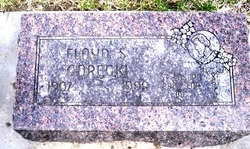
Floyd S. Gorecki
| Birth | : | 7 Apr 1907 Farwell, Howard County, Nebraska, USA |
| Death | : | 27 Jan 1999 Columbus, Platte County, Nebraska, USA |
| Burial | : | St Paul's Churchyard, Salford, Metropolitan Borough of Salford, England |
| Coordinate | : | 53.5148800, -2.2725500 |
| Description | : | Thanks to contributor #48796369 Floyd Gorecki, 91, of Columbus, formerly of Farwell, died Wednesday, Jan. 27, 1999, at Morys Haven in Columbus. Services will be at 10 a.m. Saturday at St. Bonaventure's Catholic Church in Columbus. The Rev. Dan Keller will officiate. Burial will be in St. Bonaventure's Cemetery at Columbus. Visitation will be from 3 to 9 p.m., with a 7 p.m. vigil, Friday at McKown Funeral Home in Columbus. Visitation will continue from 8 to 9:30 a.m. Saturday at the funeral home. Mr. Gorecki was born on April 7, 1907, at Farwell to Joseph and... Read More |
frequently asked questions (FAQ):
-
Where is Floyd S. Gorecki's memorial?
Floyd S. Gorecki's memorial is located at: St Paul's Churchyard, Salford, Metropolitan Borough of Salford, England.
-
When did Floyd S. Gorecki death?
Floyd S. Gorecki death on 27 Jan 1999 in Columbus, Platte County, Nebraska, USA
-
Where are the coordinates of the Floyd S. Gorecki's memorial?
Latitude: 53.5148800
Longitude: -2.2725500
Family Members:
Spouse
Siblings
Children
Flowers:
Nearby Cemetories:
1. St Paul's Churchyard
Salford, Metropolitan Borough of Salford, England
Coordinate: 53.5148800, -2.2725500
2. Rainsough Jewish Cemetery
Prestwich, Metropolitan Borough of Bury, England
Coordinate: 53.5185530, -2.2906950
3. Agecroft Cemetery and Crematorium
Salford, Metropolitan Borough of Salford, England
Coordinate: 53.5100250, -2.2940500
4. Agecroft Jewish Cemetery
Pendlebury, Metropolitan Borough of Salford, England
Coordinate: 53.5110302, -2.2955830
5. St. Marks' Churchyard
Cheetham Hill, Metropolitan Borough of Manchester, England
Coordinate: 53.5113780, -2.2462660
6. Wesleyan Methodist Cemetery
Crumpsall, Metropolitan Borough of Manchester, England
Coordinate: 53.5142870, -2.2447610
7. St. Mary the Virgin Churchyard
Prestwich, Metropolitan Borough of Bury, England
Coordinate: 53.5294033, -2.2864891
8. Great Synagogue Cemetery
Prestwich, Metropolitan Borough of Bury, England
Coordinate: 53.5315510, -2.2845730
9. St. Thomas' Churchyard
Salford, Metropolitan Borough of Salford, England
Coordinate: 53.4921430, -2.2856130
10. St John The Evangelist Churchyard
Pendlebury, Metropolitan Borough of Salford, England
Coordinate: 53.5036200, -2.3088500
11. St Luke's Churchyard
Cheetham Hill, Metropolitan Borough of Manchester, England
Coordinate: 53.5041660, -2.2354680
12. Crumpsall Jewish Cemetery
Crumpsall, Metropolitan Borough of Manchester, England
Coordinate: 53.5124250, -2.2280270
13. Blackley Cemetery and Crematorium
Blackley, Metropolitan Borough of Manchester, England
Coordinate: 53.5333176, -2.2394190
14. Strangeways Prison Cemetery (Defunct)
Manchester, Metropolitan Borough of Manchester, England
Coordinate: 53.4925000, -2.2463890
15. Blackley Presbyterian Chapel Chapelyard
Blackley, Metropolitan Borough of Manchester, England
Coordinate: 53.5233100, -2.2248110
16. St Chad's Churchyard
Cheetham Hill, Metropolitan Borough of Manchester, England
Coordinate: 53.4922100, -2.2400500
17. Saint Augustine's Churchyard
Pendlebury, Metropolitan Borough of Salford, England
Coordinate: 53.5107070, -2.3223960
18. Christ Church
Salford, Metropolitan Borough of Salford, England
Coordinate: 53.4864284, -2.2497653
19. Manchester Reform Jewish Old Cemetery
Whitefield, Metropolitan Borough of Bury, England
Coordinate: 53.5442728, -2.2918894
20. Irwell Street Wesleyan Chapel Cemetery
Salford, Metropolitan Borough of Salford, England
Coordinate: 53.4829750, -2.2587540
21. St. Peter's Churchyard
Blackley, Metropolitan Borough of Manchester, England
Coordinate: 53.5231200, -2.2188900
22. New Jerusalem Temple Cemetery
Salford, Metropolitan Borough of Salford, England
Coordinate: 53.4827720, -2.2571250
23. Manchester General Cemetery
Manchester, Metropolitan Borough of Manchester, England
Coordinate: 53.5062710, -2.2179570
24. Manchester Cathedral
Manchester, Metropolitan Borough of Manchester, England
Coordinate: 53.4852760, -2.2446010

