

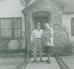
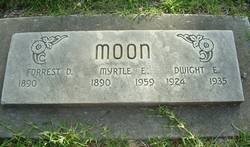
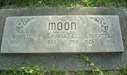
Forrest Dwight Moon
| Birth | : | 24 May 1890 Nebraska, USA |
| Death | : | 12 Jan 1967 Chico, Butte County, California, USA |
| Burial | : | Rose Hill Cemetery, Hebron, Thayer County, USA |
| Coordinate | : | 40.1889000, -97.5960999 |
| Description | : | There is no death date on headstone but according to the California Death Index he died on this date. Forrest married Myrtle E. Butolph 24 June 1911 in Franklin County, Ks. |
frequently asked questions (FAQ):
-
Where is Forrest Dwight Moon's memorial?
Forrest Dwight Moon's memorial is located at: Rose Hill Cemetery, Hebron, Thayer County, USA.
-
When did Forrest Dwight Moon death?
Forrest Dwight Moon death on 12 Jan 1967 in Chico, Butte County, California, USA
-
Where are the coordinates of the Forrest Dwight Moon's memorial?
Latitude: 40.1889000
Longitude: -97.5960999
Family Members:
Parent
Spouse
Siblings

Children
Flowers:


Nearby Cemetories:
1. Sacred Heart Cemetery
Hebron, Thayer County, USA
Coordinate: 40.1767006, -97.5880966
2. Hebron City Cemetery
Hebron, Thayer County, USA
Coordinate: 40.1753006, -97.5877991
3. Old Hebron Cemetery
Hebron, Thayer County, USA
Coordinate: 40.1758003, -97.5852966
4. King David Fisher Gravesite
Hebron, Thayer County, USA
Coordinate: 40.1509440, -97.5438060
5. Saint Mark Evangelical Lutheran Cemetery
Thayer County, USA
Coordinate: 40.1331500, -97.6205900
6. Letterman Cemetery
Deshler, Thayer County, USA
Coordinate: 40.1614500, -97.6708000
7. Thayer County Poor Farm Cemetery
Hebron, Thayer County, USA
Coordinate: 40.1585900, -97.5173370
8. Friedensau Cemetery
Hebron, Thayer County, USA
Coordinate: 40.1841100, -97.6895500
9. Belvidere Rural Cemetery
Belvidere, Thayer County, USA
Coordinate: 40.2559200, -97.5489300
10. Dan Schafer Family Farm Cemetery
Hebron, Thayer County, USA
Coordinate: 40.1181500, -97.5437200
11. Deshler City Cemetery
Deshler, Thayer County, USA
Coordinate: 40.1468506, -97.7135620
12. Saint Peter Lutheran Cemetery
Deshler, Thayer County, USA
Coordinate: 40.1464005, -97.7142029
13. Peace Lutheran Cemetery
Deshler, Thayer County, USA
Coordinate: 40.1464005, -97.7213974
14. Kennedy Lone Grave
Gilead, Thayer County, USA
Coordinate: 40.1715900, -97.4425500
15. Saint Paul Lutheran Cemetery - Stoddard
Chester, Thayer County, USA
Coordinate: 40.0760300, -97.6515300
16. Carleton Cemetery
Carleton, Thayer County, USA
Coordinate: 40.2929000, -97.6764000
17. Mount Gilead Cemetery
Gilead, Thayer County, USA
Coordinate: 40.1906000, -97.4246500
18. Immanuel Evangelical Lutheran Cemetery
Deshler, Thayer County, USA
Coordinate: 40.1473400, -97.7605700
19. Keim Cemetery
Bruning, Thayer County, USA
Coordinate: 40.3222008, -97.6033020
20. Saint Paul's Lutheran Church Cemetery
Gilead, Thayer County, USA
Coordinate: 40.1108000, -97.4449000
21. Bethlehem Cemetery
Kiowa Township, Thayer County, USA
Coordinate: 40.2055800, -97.7838800
22. Trinity Lutheran Cemetery
Bruning, Thayer County, USA
Coordinate: 40.3367800, -97.5566900
23. Bruning Public Cemetery
Bruning, Thayer County, USA
Coordinate: 40.3393100, -97.5579000
24. Union Cemetery
Gilead, Thayer County, USA
Coordinate: 40.1319008, -97.4047012