
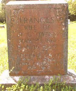
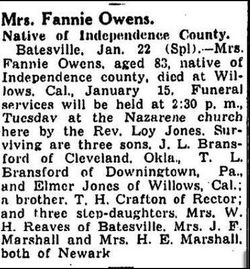
Frances Ann “Fannie” Crafton Owens
| Birth | : | 23 Mar 1861 |
| Death | : | 16 Jan 1945 |
| Burial | : | St Mary's Parish Churchyard, Ashby St Mary, South Norfolk District, England |
| Coordinate | : | 52.5679100, 1.4354760 |
| Inscription | : | wife of W. C. |
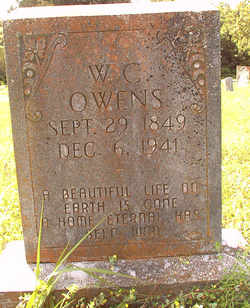
| Description | : | Daughter of - Tillman Lafayette Crafton 1839–1922. Marriage: 30 Dec 1858 Independence Co. Ar. Martha Matilda Carter 1840–1909 Siblings - James L. Crafton 1865– Nancy M. Crafton 1867- Isaac J. Crafton 1870– Tilman Hardy Crafton 1873– ///////// Married 1. William Bransford 1876 2. James Walker Jones 1890 3. Dan Stout 1901 4. William Cass Owens 1907 Children - John Tillman Bransford b 1878 m Louisiana A 1899 Idel Bransford b 1879 m Thomas Lagar Jones Thomas Lafayette Bransford b 1883 m... Read More |
frequently asked questions (FAQ):
-
Where is Frances Ann “Fannie” Crafton Owens's memorial?
Frances Ann “Fannie” Crafton Owens's memorial is located at: St Mary's Parish Churchyard, Ashby St Mary, South Norfolk District, England.
-
When did Frances Ann “Fannie” Crafton Owens death?
Frances Ann “Fannie” Crafton Owens death on 16 Jan 1945 in
-
Where are the coordinates of the Frances Ann “Fannie” Crafton Owens's memorial?
Latitude: 52.5679100
Longitude: 1.4354760
Family Members:
Flowers:


Nearby Cemetories:
1. St Mary's Parish Churchyard
Ashby St Mary, South Norfolk District, England
Coordinate: 52.5679100, 1.4354760
2. St Andrews
Claxton, South Norfolk District, England
Coordinate: 52.5769660, 1.4340060
3. St Peter's Churchyard
Carleton St Peter, South Norfolk District, England
Coordinate: 52.5680520, 1.4514100
4. St. John the Baptist Churchyard
Hellington, South Norfolk District, England
Coordinate: 52.5761440, 1.4132050
5. St. Mary's Churchyard
Rockland St Mary, South Norfolk District, England
Coordinate: 52.5843940, 1.4112390
6. St. Michaels's Church Cemetery
Langley with Hardley, South Norfolk District, England
Coordinate: 52.5552220, 1.4727530
7. St. Peter and St. Paul Churchyard
Bergh Apton, South Norfolk District, England
Coordinate: 52.5480290, 1.4060870
8. Langley Abbey
Langley with Hardley, South Norfolk District, England
Coordinate: 52.5719000, 1.4875700
9. St Peter Churchyard
Bramerton, South Norfolk District, England
Coordinate: 52.5914090, 1.3885040
10. St Peter's Churchyard
Mundham, South Norfolk District, England
Coordinate: 52.5303890, 1.4260120
11. Hardley Methodist Chapel
Langley with Hardley, South Norfolk District, England
Coordinate: 52.5577290, 1.4957960
12. St Margaret and St Remigius Churchyard
Seething, South Norfolk District, England
Coordinate: 52.5303390, 1.4185000
13. All Saints Churchyard
Chedgrave, South Norfolk District, England
Coordinate: 52.5409130, 1.4831200
14. St Peters Churchyard
Brooke, South Norfolk District, England
Coordinate: 52.5452560, 1.3814930
15. St. Nicholas' Churchyard
Buckenham, Broadland District, England
Coordinate: 52.5995590, 1.4770110
16. Holy Trinity Churchyard
Loddon, South Norfolk District, England
Coordinate: 52.5350430, 1.4832560
17. St Margaret's Churchyard
Kirstead, South Norfolk District, England
Coordinate: 52.5358860, 1.3840860
18. St. Mary's Churchyard
Hassingham, Broadland District, England
Coordinate: 52.5958770, 1.4963330
19. St Andrew Churchyard
Framingham Earl, South Norfolk District, England
Coordinate: 52.5748560, 1.3596480
20. St Andrew Churchyard
Framingham Pigot, South Norfolk District, England
Coordinate: 52.5826070, 1.3606380
21. St. Margaret Churchyard
Cantley, Broadland District, England
Coordinate: 52.5826600, 1.5137200
22. St Margaret's Churchyard
Hardley Street, South Norfolk District, England
Coordinate: 52.5522980, 1.5170630
23. All Saints Churchyard
Poringland, South Norfolk District, England
Coordinate: 52.5657160, 1.3496310
24. St. Peter's Churchyard
Strumpshaw, Broadland District, England
Coordinate: 52.6163970, 1.4688640