
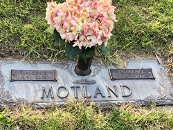
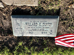
Frances Elizabeth Dunton Motland
| Birth | : | 6 Sep 1919 Worth County, Iowa, USA |
| Death | : | 13 Sep 2008 Mason City, Cerro Gordo County, Iowa, USA |
| Burial | : | Helston Cemetery, Helston, Cornwall Unitary Authority, England |
| Coordinate | : | 50.0956590, -5.2690150 |
frequently asked questions (FAQ):
-
Where is Frances Elizabeth Dunton Motland's memorial?
Frances Elizabeth Dunton Motland's memorial is located at: Helston Cemetery, Helston, Cornwall Unitary Authority, England.
-
When did Frances Elizabeth Dunton Motland death?
Frances Elizabeth Dunton Motland death on 13 Sep 2008 in Mason City, Cerro Gordo County, Iowa, USA
-
Where are the coordinates of the Frances Elizabeth Dunton Motland's memorial?
Latitude: 50.0956590
Longitude: -5.2690150
Family Members:
Parent

Spouse

Siblings
Flowers:


Nearby Cemetories:
1. St Michael Churchyard
Helston, Cornwall Unitary Authority, England
Coordinate: 50.1033570, -5.2765600
2. Breage Parish Council Cemetery
Breage, Cornwall Unitary Authority, England
Coordinate: 50.1080600, -5.3306300
3. Breage War Memorial Cemetery
Breage, Cornwall Unitary Authority, England
Coordinate: 50.1080100, -5.3314400
4. St. Breaca New Church Cemetery
Breage, Cornwall Unitary Authority, England
Coordinate: 50.1088900, -5.3316800
5. St. Breaca Churchyard
Breage, Cornwall Unitary Authority, England
Coordinate: 50.1083210, -5.3321080
6. Cury Cemetery
Helston, Cornwall Unitary Authority, England
Coordinate: 50.0471500, -5.2462600
7. St Corentine Churchyard
Cury, Cornwall Unitary Authority, England
Coordinate: 50.0461920, -5.2452850
8. St. Winwaloe Churchyard
Gunwalloe, Cornwall Unitary Authority, England
Coordinate: 50.0389880, -5.2690600
9. St John the Baptist Churchyard
Godolphin Cross, Cornwall Unitary Authority, England
Coordinate: 50.1333830, -5.3470240
10. St Constantine Churchyard
Constantine, Cornwall Unitary Authority, England
Coordinate: 50.1181980, -5.1748880
11. Balwest Chapel Cemetery
Germoe, Cornwall Unitary Authority, England
Coordinate: 50.1213610, -5.3644730
12. Crowan Anglican Churchyard
Crowan, Cornwall Unitary Authority, England
Coordinate: 50.1637320, -5.2976630
13. Ss Manaccus & Dunstan Churchyard
Manaccan, Cornwall Unitary Authority, England
Coordinate: 50.0830860, -5.1269460
14. St Dunstan Church Cemetery
Manaccan, Cornwall Unitary Authority, England
Coordinate: 50.0836800, -5.1255200
15. Mabe Churchyard
Mabe, Cornwall Unitary Authority, England
Coordinate: 50.1497800, -5.1404600
16. St. John the Evangelist Churchyard
Camborne, Cornwall Unitary Authority, England
Coordinate: 50.1935761, -5.2931032
17. St. Peter Churchyard
Flushing, Cornwall Unitary Authority, England
Coordinate: 50.0844440, -5.1009980
18. Killivose Cemetery
Camborne, Cornwall Unitary Authority, England
Coordinate: 50.2027700, -5.3036500
19. St. Gwinear Churchyard
Gwinear, Cornwall Unitary Authority, England
Coordinate: 50.1874090, -5.3706170
20. Gwinear Parish Church Cemetery
Gwinear, Cornwall Unitary Authority, England
Coordinate: 50.1879940, -5.3714960
21. St. Martin and St. Meriadoc Churchyard
Camborne, Cornwall Unitary Authority, England
Coordinate: 50.2134190, -5.3020460
22. Centenary Methodist Chapel & Cemetery
Camborne, Cornwall Unitary Authority, England
Coordinate: 50.2147340, -5.2928470
23. St Budock Churchyard
Budock, Cornwall Unitary Authority, England
Coordinate: 50.1501600, -5.1003360
24. Camborne Cemetery
Camborne, Cornwall Unitary Authority, England
Coordinate: 50.2157510, -5.3098940