


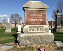
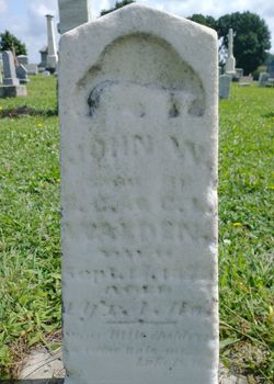
Francis Curtis “Frank” Walden
| Birth | : | 6 May 1827 Southington Township, Trumbull County, Ohio, USA |
| Death | : | 10 Sep 1908 Farmer Township, Defiance County, Ohio, USA |
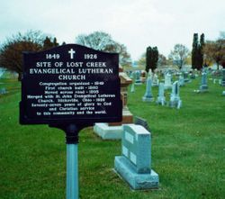
| Burial | : | Lost Creek Cemetery, Farmer, Defiance County, USA |
| Coordinate | : | 41.3553000, -84.6700000 |
| Plot | : | Row 1 Next to State Route #2 |
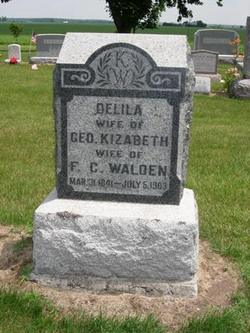
| Inscription | : | Francis C. Walden / 1827 - 1908 |
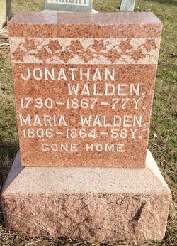
| Description | : | Francis Curtis Walden was born on May 6, 1827, in Trumbull County, Ohio, to Jonathan and Mariah (Curtis) Walden. Celia Lydia Curtis was born on July 6, 1833, also in Trumbull County, to George W. and Lydia (Warner) Curtis. In the late 1830s, the Jonathan Walden family moved to Allen County, Ohio, with the George Curtis family following in the late 1840s. Francis and Celia (then 17 years old) were married in Allen County on April 8, 1850. In 1853, Francis, Celia, and their children, along with Francis’ parents, relocated to Defiance County, Ohio, after Jonathan Walden... Read More |
frequently asked questions (FAQ):
-
Where is Francis Curtis “Frank” Walden's memorial?
Francis Curtis “Frank” Walden's memorial is located at: Lost Creek Cemetery, Farmer, Defiance County, USA.
-
When did Francis Curtis “Frank” Walden death?
Francis Curtis “Frank” Walden death on 10 Sep 1908 in Farmer Township, Defiance County, Ohio, USA
-
Where are the coordinates of the Francis Curtis “Frank” Walden's memorial?
Latitude: 41.3553000
Longitude: -84.6700000
Family Members:
Parent
Spouse
Siblings

Children
Flowers:


Nearby Cemetories:
1. Lost Creek Cemetery
Farmer, Defiance County, USA
Coordinate: 41.3553000, -84.6700000
2. Kemp Cemetery
Defiance County, USA
Coordinate: 41.3703003, -84.6802979
3. Upper Lost Creek Cemetery
Farmer, Defiance County, USA
Coordinate: 41.3840000, -84.6700000
4. Farmer Cemetery
Farmer, Defiance County, USA
Coordinate: 41.3903008, -84.6410980
5. Six Corners Cemetery
Hicksville, Defiance County, USA
Coordinate: 41.3213997, -84.7153015
6. Tamarack Cemetery
Milford Township, Defiance County, USA
Coordinate: 41.4117012, -84.7089005
7. Hicksville Christian Cemetery
Hicksville, Defiance County, USA
Coordinate: 41.3231700, -84.7543660
8. Saint Johns Lutheran Cemetery
Sherwood, Defiance County, USA
Coordinate: 41.3092003, -84.5931015
9. Hicksville Amish Cemetery
Hicksville, Defiance County, USA
Coordinate: 41.3363920, -84.7655710
10. Zion Lutheran Church Cemetery
Defiance County, USA
Coordinate: 41.4261017, -84.7099991
11. Williams Center Cemetery
Williams Center, Williams County, USA
Coordinate: 41.4288902, -84.6125031
12. Hicksville Cemetery (Defunct)
Hicksville, Defiance County, USA
Coordinate: 41.2963360, -84.7579760
13. Spindler Cemetery
Mark Center, Defiance County, USA
Coordinate: 41.2625008, -84.6697006
14. Forest Home Cemetery
Hicksville, Defiance County, USA
Coordinate: 41.3022003, -84.7750015
15. Lintz Cemetery
Ney, Defiance County, USA
Coordinate: 41.3760986, -84.5402985
16. Clarksville Cemetery
Edgerton, Williams County, USA
Coordinate: 41.4281006, -84.7677994
17. Fetters Cemetery
Williams County, USA
Coordinate: 41.4519500, -84.6159900
18. Maple Grove Cemetery
Edgerton, Williams County, USA
Coordinate: 41.4435997, -84.7521973
19. St. Mary's Cemetery
Edgerton, Williams County, USA
Coordinate: 41.4441120, -84.7542700
20. Melbern-Neihardt Cemetery
Melbern, Williams County, USA
Coordinate: 41.4633600, -84.6416330
21. Sherwood Cemetery
Sherwood, Defiance County, USA
Coordinate: 41.2900009, -84.5507965
22. Trinity Lutheran Cemetery
Ney, Defiance County, USA
Coordinate: 41.4016991, -84.5353012
23. Ney Cemetery
Ney, Defiance County, USA
Coordinate: 41.3856010, -84.5271988
24. Wartenbe Cemetery
Stafford Township, DeKalb County, USA
Coordinate: 41.3746986, -84.8171997