
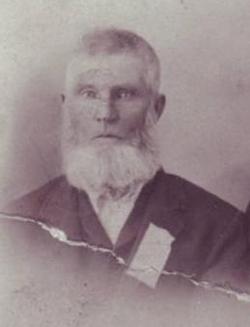
Francis Everett Amsberry
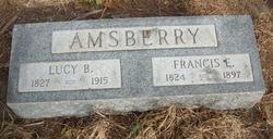
| Birth | : | 18 Jan 1824 Mason County, West Virginia, USA |
| Death | : | 6 Aug 1897 Mason City, Custer County, Nebraska, USA |
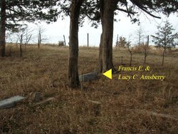
| Burial | : | Woodstock Cemetery, Woodstock, Grafton County, USA |
| Coordinate | : | 43.9827600, -71.6827500 |
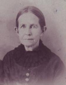
| Description | : | Son of William Allen Amsberry of Chautauqua County, New York and Mary Polly Everett of Chelsea, Orange County, Vermont. Husband of Lucy Caroline Beard of Lynchburg, Bedford County, Virginia, married on 03 March 1848 in Mason County, West Virginia. On March 4, 1885 the Francis E. Amsberry family left West Virginia for Nebraska. His son, John Allen Amsberry and his nephew, Darius Amsberry, had found valuable government land in Custer County and had notified relations about the opening for settlement. Francis rented a freight or immigrant railroad car, 60' X 10'. On this they stored their furniture and belongings and... Read More |
frequently asked questions (FAQ):
-
Where is Francis Everett Amsberry's memorial?
Francis Everett Amsberry's memorial is located at: Woodstock Cemetery, Woodstock, Grafton County, USA.
-
When did Francis Everett Amsberry death?
Francis Everett Amsberry death on 6 Aug 1897 in Mason City, Custer County, Nebraska, USA
-
Where are the coordinates of the Francis Everett Amsberry's memorial?
Latitude: 43.9827600
Longitude: -71.6827500
Family Members:
Parent
Spouse
Siblings

Children

Flowers:


Nearby Cemetories:
1. Woodstock Cemetery
Woodstock, Grafton County, USA
Coordinate: 43.9827600, -71.6827500
2. Wildcat Cemetery
Thornton, Grafton County, USA
Coordinate: 43.9909710, -71.6391440
3. Parker Cemetery
Woodstock, Grafton County, USA
Coordinate: 44.0193000, -71.6839700
4. Jackman Cemetery
Grafton County, USA
Coordinate: 44.0322220, -71.6969440
5. Clark's Trading Post Animal Cemetery
Lincoln, Grafton County, USA
Coordinate: 44.0483740, -71.6862130
6. Riverside Cemetery
Lincoln, Grafton County, USA
Coordinate: 44.0505900, -71.6856100
7. Pine Grove Cemetery
Thornton, Grafton County, USA
Coordinate: 43.9060100, -71.6689000
8. West Thornton Cemetery
Thornton, Grafton County, USA
Coordinate: 43.8997200, -71.6805600
9. Hanson Farm Road Cemetery
Lincoln, Grafton County, USA
Coordinate: 44.0663890, -71.6869440
10. Yeaton Cemetery
Thornton, Grafton County, USA
Coordinate: 43.8963800, -71.6794500
11. Blake Mountain Cemetery
Thornton, Grafton County, USA
Coordinate: 43.8963600, -71.6794200
12. Packard Graveyard
Thornton, Grafton County, USA
Coordinate: 43.8971540, -71.5845930
13. Mad River Cemetery
Thornton, Grafton County, USA
Coordinate: 43.8833670, -71.6077500
14. Avery Cemetery
Ellsworth, Grafton County, USA
Coordinate: 43.8805600, -71.7511200
15. Pease Cemetery
Ellsworth, Grafton County, USA
Coordinate: 43.8741100, -71.7382000
16. Old Baptist Church Cemetery
Ellsworth, Grafton County, USA
Coordinate: 43.8738890, -71.7430560
17. Burbank Foss Cemetery
Campton Lower Village, Grafton County, USA
Coordinate: 43.8955730, -71.5667000
18. West Campton Cemetery
Grafton County, USA
Coordinate: 43.8622220, -71.7052780
19. Town Line Cemetery
Campton, Grafton County, USA
Coordinate: 43.8614570, -71.6678870
20. Campton Village Cemetery
Campton, Grafton County, USA
Coordinate: 43.8654440, -71.6364380
21. Waterville Valley Cemetery
Waterville Valley, Grafton County, USA
Coordinate: 43.9634670, -71.5087000
22. Blake Cemetery
Stinson Lake, Grafton County, USA
Coordinate: 43.8827780, -71.7975000
23. Partridge Hill Cemetery
West Campton, Grafton County, USA
Coordinate: 43.8428700, -71.7046900
24. Brown Farmstead Cemetery
Benton, Grafton County, USA
Coordinate: 44.0778000, -71.8420830