
| Birth | : | 25 Jan 1849 Germanton, Stokes County, North Carolina, USA |
| Death | : | 12 Oct 1927 Stokes County, North Carolina, USA |
| Burial | : | St James' Church Cemetery, Hockwold, Kings Lynn and West Norfolk Borough, England |
| Coordinate | : | 52.4625100, 0.5519400 |
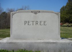
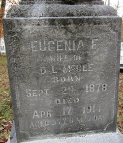
| Description | : | A son of Riley Frost and Oletha Mary Ann Helsabeck Petree. Husband of Julia Ann Fannie Rierson Petree. Father of Eugenia, Flora, Sarah, Ellen, Robert Garfield, Francis, Nathaniel Blaine, Virginia, William R., John and Joseph (twins), Carlton and Ethel Constance Petree. The family lived at a farm they called "Cherry Hill". |
frequently asked questions (FAQ):
-
Where is Francis Ezekial “Frank” Petree's memorial?
Francis Ezekial “Frank” Petree's memorial is located at: St James' Church Cemetery, Hockwold, Kings Lynn and West Norfolk Borough, England.
-
When did Francis Ezekial “Frank” Petree death?
Francis Ezekial “Frank” Petree death on 12 Oct 1927 in Stokes County, North Carolina, USA
-
Where are the coordinates of the Francis Ezekial “Frank” Petree's memorial?
Latitude: 52.4625100
Longitude: 0.5519400
Family Members:
Parent

Spouse
Siblings
Children
Flowers:


Nearby Cemetories:
1. St James' Church Cemetery
Hockwold, Kings Lynn and West Norfolk Borough, England
Coordinate: 52.4625100, 0.5519400
2. St. Peter Church Cemetery
Hockwold, Kings Lynn and West Norfolk Borough, England
Coordinate: 52.4627780, 0.5376030
3. St. Mary's Churchyard
Feltwell, Kings Lynn and West Norfolk Borough, England
Coordinate: 52.4874580, 0.5245110
4. St Nicholas Churchyard
Feltwell, Kings Lynn and West Norfolk Borough, England
Coordinate: 52.4888000, 0.5209700
5. St. Peter's Churchyard
Brandon, Forest Heath District, England
Coordinate: 52.4445800, 0.6132600
6. Brandon Cemetery
Brandon, Forest Heath District, England
Coordinate: 52.4445140, 0.6149550
7. New Beginnings International Churchyard
Wangford, Forest Heath District, England
Coordinate: 52.4215680, 0.5733170
8. Lakenheath Cemetery
Lakenheath, Forest Heath District, England
Coordinate: 52.4177780, 0.5282760
9. St. George's Churchyard
Methwold, Kings Lynn and West Norfolk Borough, England
Coordinate: 52.5229060, 0.5568700
10. Methwold Cemetery
Methwold, Kings Lynn and West Norfolk Borough, England
Coordinate: 52.5257758, 0.5575197
11. St Mary the Virgin Churchyard
Santon Downham, Forest Heath District, England
Coordinate: 52.4562840, 0.6715820
12. St Mary's Churchyard
Cranwich, Breckland Borough, England
Coordinate: 52.5224040, 0.6262310
13. St Leonard's Churchyard
Mundford, Breckland Borough, England
Coordinate: 52.5125080, 0.6521150
14. St. Andrew's Old Cemetery
Northwold, Kings Lynn and West Norfolk Borough, England
Coordinate: 52.5405523, 0.5864157
15. Northwold Cemetery
Northwold, Kings Lynn and West Norfolk Borough, England
Coordinate: 52.5419000, 0.5820000
16. St Andrew Churchyard
Northwold, Kings Lynn and West Norfolk Borough, England
Coordinate: 52.5425540, 0.5878920
17. All Saints Churchyard
Santon Downham, Forest Heath District, England
Coordinate: 52.4525750, 0.6904240
18. All Saints Churchyard
Santon, St Edmundsbury Borough, England
Coordinate: 52.4525440, 0.6904210
19. St. Laurence and St. Peter Churchyard
Eriswell, Forest Heath District, England
Coordinate: 52.3733400, 0.5306300
20. St Peter's Churchyard
Ickburgh, Breckland Borough, England
Coordinate: 52.5232010, 0.6755200
21. Methodist Chapel
Holywell Row, Forest Heath District, England
Coordinate: 52.3661040, 0.5067880
22. Beck Row Methodist Churchyard
Beck Row, Forest Heath District, England
Coordinate: 52.3701225, 0.4866503
23. All Saints Churchyard
Foulden, Breckland Borough, England
Coordinate: 52.5599040, 0.6021930
24. St. John's Churchyard
Beck Row, Forest Heath District, England
Coordinate: 52.3663830, 0.4947150