
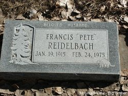
Francis “Pete” Reidelbach
| Birth | : | 19 Jan 1915 Seneca County, Ohio, USA |
| Death | : | 24 Feb 1975 Park County, Montana, USA |
| Burial | : | Stapenhill Cemetery, Burton upon Trent, East Staffordshire Borough, England |
| Coordinate | : | 52.8026310, -1.6208900 |
| Plot | : | Section 5 Blk 35M Lot 1 Grave 5 |
| Description | : | Big Timber Pioneer, February 26, 1975 Pete Reidelbach Funeral services will be held Thursday at Lowry Funeral Home for Pete Reidelbach, 60, who died early Monday morning at his home in Livingston. He was born January 19, 1915, in Tiffin, Ohio, a son of Mr. and Mrs. Frank Reidelbach. He was raised in an orphanage in Tiffin. He came to Big Timber in 1933 and worked on ranches in the area. He worked for the Billings Rendering Company for ten years, operated a mink ranch, drove a school bus, and had worked for R and R Locker Plant for the... Read More |
frequently asked questions (FAQ):
-
Where is Francis “Pete” Reidelbach's memorial?
Francis “Pete” Reidelbach's memorial is located at: Stapenhill Cemetery, Burton upon Trent, East Staffordshire Borough, England.
-
When did Francis “Pete” Reidelbach death?
Francis “Pete” Reidelbach death on 24 Feb 1975 in Park County, Montana, USA
-
Where are the coordinates of the Francis “Pete” Reidelbach's memorial?
Latitude: 52.8026310
Longitude: -1.6208900
Family Members:
Parent
Spouse
Siblings

Children
Flowers:


Nearby Cemetories:
1. Stapenhill Cemetery
Burton upon Trent, East Staffordshire Borough, England
Coordinate: 52.8026310, -1.6208900
2. Garden of Remembrance
Burton upon Trent, East Staffordshire Borough, England
Coordinate: 52.8023045, -1.6283625
3. St Modwen Churchyard
Burton upon Trent, East Staffordshire Borough, England
Coordinate: 52.8013990, -1.6291340
4. St. Peter's Parish Churchyard
Stapenhill, East Staffordshire Borough, England
Coordinate: 52.7960899, -1.6230323
5. St Mark Churchyard
Winshill, East Staffordshire Borough, England
Coordinate: 52.8082040, -1.6048350
6. Saint John the Divine Churchyard
Horninglow, East Staffordshire Borough, England
Coordinate: 52.8237520, -1.6426170
7. Bretby Crematorium
Burton upon Trent, East Staffordshire Borough, England
Coordinate: 52.8008590, -1.5724250
8. Saint Saviour's Cemetery
Burton upon Trent, East Staffordshire Borough, England
Coordinate: 52.7892907, -1.6668628
9. St Mary's Churchyard
Stretton, South Staffordshire Borough, England
Coordinate: 52.8336500, -1.6253400
10. St Mary's Church
Stretton, East Staffordshire Borough, England
Coordinate: 52.8341478, -1.6247215
11. St. John's Churchyard
Newhall, South Derbyshire District, England
Coordinate: 52.7825310, -1.5685700
12. Swadlincote Newhall and Stanton Burial Ground
Swadlincote, South Derbyshire District, England
Coordinate: 52.7818200, -1.5683500
13. St. Wilfrid Churchyard
Egginton, South Derbyshire District, England
Coordinate: 52.8474570, -1.6041750
14. St. Michael and All Angels Churchyard
Tatenhill, East Staffordshire Borough, England
Coordinate: 52.7958170, -1.6968150
15. St. Mary's Churchyard
Rolleston-on-Dove, East Staffordshire Borough, England
Coordinate: 52.8465144, -1.6519844
16. Church Gresley Cemetery
Church Gresley, South Derbyshire District, England
Coordinate: 52.7666760, -1.5626180
17. Rolleston Cemetery
Rolleston-on-Dove, East Staffordshire Borough, England
Coordinate: 52.8483757, -1.6643849
18. St. George and St. Mary Churchyard
Church Gresley, South Derbyshire District, England
Coordinate: 52.7597610, -1.5669370
19. St Laurence Churchyard
Walton-on-Trent, South Derbyshire District, England
Coordinate: 52.7613386, -1.6819775
20. Holy Trinity Churchyard
Anslow, East Staffordshire Borough, England
Coordinate: 52.8216926, -1.7079807
21. St. Wystan's Churchyard
Repton, South Derbyshire District, England
Coordinate: 52.8411570, -1.5516380
22. St Michael Churchyard
Willington, South Derbyshire District, England
Coordinate: 52.8501540, -1.5636540
23. St Mary's
Marston-on-Dove, South Derbyshire District, England
Coordinate: 52.8633910, -1.6547730
24. Marston-on-Dove Cemetery
Marston-on-Dove, South Derbyshire District, England
Coordinate: 52.8640550, -1.6552780