
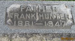
Frank Hunter
| Birth | : | May 1861 |
| Death | : | 31 Jan 1947 New Lyme, Ashtabula County, Ohio, USA |
| Burial | : | Penrhys Cemetery, Wales |
| Coordinate | : | 51.6420500, -3.4425800 |
| Description | : | Final services for Franklin Hunter, 86, former local resi- dent, will be this afternoon at 3 o'clock at the Chase-Miller chapel. The Reverend J. Vergil Siberal will officiate and burial will be in the Idaville cemetery. The body will arrive at the chapel at noon today from Andover, Ohio, where death occurred Wednesday. THE LOGANSPORT PRESS. LOGANSPORT, INDIANA SATURDAY, FEBRUARY 1.1947 |
frequently asked questions (FAQ):
-
Where is Frank Hunter's memorial?
Frank Hunter's memorial is located at: Penrhys Cemetery, Wales.
-
When did Frank Hunter death?
Frank Hunter death on 31 Jan 1947 in New Lyme, Ashtabula County, Ohio, USA
-
Where are the coordinates of the Frank Hunter's memorial?
Latitude: 51.6420500
Longitude: -3.4425800
Family Members:
Parent

Spouse
Siblings
Children
Flowers:


Nearby Cemetories:
1. Penrhys Cemetery
Wales
Coordinate: 51.6420500, -3.4425800
2. Holy Trinity Churchyard
Ilfracombe, North Devon District, England
Coordinate: 51.5571712, -3.5946496
3. Newcastle St. Illtyd Churchyard
Wales
Coordinate: 51.5080900, -3.5829600
4. St George's Churchyard
Wales
Coordinate: 51.4819300, -3.2911700
5. St Nicholas Church
Wales
Coordinate: 51.4605000, -3.3098000
6. Twyn yr Odyn Baptist Chapel Burial Ground
Wales
Coordinate: 51.4563708, -3.2739268
7. Saint David's Churchyard
Wales
Coordinate: 51.8017440, -3.6967650
8. St. Peter's Churchyard
Wales
Coordinate: 51.6133800, -3.0590490
9. St David Church Burial Ground
Wales
Coordinate: 51.7703100, -3.7884600
10. Godre'r Graig Independent Chapel Cemetery
Wales
Coordinate: 51.7474400, -3.8089300
11. Alltwen Welsh Congregational Chapelyard
Wales
Coordinate: 51.7139600, -3.8444700
12. St Elli’s Churchyard
Wales
Coordinate: 51.8264420, -3.1154820
13. Rhyd-Y-Fro Saron Congregational Old Chapelyard
Wales
Coordinate: 51.7379400, -3.8662700
14. St. Peter's Churchyard
Wales
Coordinate: 51.7364689, -2.9735286
15. St. Cadoc
Wales
Coordinate: 51.7818400, -2.9716800
16. Three Crosses Churchyard, Capel y Crwys
Wales
Coordinate: 51.6278387, -4.0653017
17. St. John the Baptist Churchyard
Weston-super-Mare, North Somerset Unitary Authority, England
Coordinate: 51.3523010, -2.9813260
18. Saint Pauls Churchyard
Kewstoke, North Somerset Unitary Authority, England
Coordinate: 51.3655500, -2.9568900
19. St Paul's Churchyard
Kewstoke, North Somerset Unitary Authority, England
Coordinate: 51.3655390, -2.9566120
20. Clevedon Cemetery
Clevedon, North Somerset Unitary Authority, England
Coordinate: 51.4322600, -2.8747270
21. St Andrew Churchyard
Clevedon, North Somerset Unitary Authority, England
Coordinate: 51.4331670, -2.8735760
22. Weston-Super-Mare Cemetery
Weston-super-Mare, North Somerset Unitary Authority, England
Coordinate: 51.3541300, -2.9676900
23. Llandingat Parish Church
Wales
Coordinate: 51.9914392, -3.8022458
24. Weston-super-Mare Emmanuel Churchyard
Weston-super-Mare, North Somerset Unitary Authority, England
Coordinate: 51.3458940, -2.9773860