
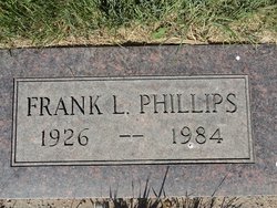
Frank Leo Phillips
| Birth | : | 23 Sep 1926 Hingham, Hill County, Montana, USA |
| Death | : | 12 Mar 1984 Havre, Hill County, Montana, USA |
| Burial | : | Rudyard Cemetery, Rudyard, Hill County, USA |
| Coordinate | : | 48.5659500, -110.5390000 |
| Description | : | 1/28/2022: Suggested edit: Great Falls Tribune (MT), 15 March 1984 Frank L. Phillips Rudyard--Frank L. Phillips, 57, died Monday in a Havre hospital. Services will be Thursday at 2 p.m. at Our Savior's Lutheran Church in Rudyard, followed by burial in Rudyard Cemetery. Born in Hingham, he grew up there. Phillips was married to Joan M. Haaland in Havre in Sept. 1948. They farmed in the Rudyard area and he also operated Phillips Implement Business until 1974. His wife survives with four daughters, Martia Swanson, Calgary, Alta., Jan Phillips, Inverness, Dana Eliason, Spokane, Wash., and Rhonda Ritter, Rudyard; a son,... Read More |
frequently asked questions (FAQ):
-
Where is Frank Leo Phillips's memorial?
Frank Leo Phillips's memorial is located at: Rudyard Cemetery, Rudyard, Hill County, USA.
-
When did Frank Leo Phillips death?
Frank Leo Phillips death on 12 Mar 1984 in Havre, Hill County, Montana, USA
-
Where are the coordinates of the Frank Leo Phillips's memorial?
Latitude: 48.5659500
Longitude: -110.5390000
Family Members:
Parent
Siblings

Flowers:


Nearby Cemetories:
1. Rudyard Cemetery
Rudyard, Hill County, USA
Coordinate: 48.5659500, -110.5390000
2. Hingham Union Cemetery
Hingham, Hill County, USA
Coordinate: 48.5601570, -110.4178980
3. Inverness Cemetery
Hill County, USA
Coordinate: 48.5531340, -110.6688450
4. Bethel Cemetery
Hill County, USA
Coordinate: 48.6685982, -110.6406021
5. Joplin Cemetery
Joplin, Liberty County, USA
Coordinate: 48.5576720, -110.7622930
6. Gildford Hill County Cemetery
Gildford, Hill County, USA
Coordinate: 48.5778008, -110.2957993
7. Cool Spring Colony Cemetery
Rudyard, Hill County, USA
Coordinate: 48.7704000, -110.5860000
8. Milk River Valley Church Graveyard
Hill County, USA
Coordinate: 48.6787180, -110.2261080
9. Cottonwood Lutheran Church Cemetery
Havre, Hill County, USA
Coordinate: 48.4545000, -110.1748000
10. Grace Church Cemetery
Rudyard, Hill County, USA
Coordinate: 48.8269930, -110.6209890
11. Chester Cemetery
Chester, Liberty County, USA
Coordinate: 48.5219002, -110.9807968
12. Saint Wenceslaus Cemetery
Goldstone, Hill County, USA
Coordinate: 48.9002610, -110.5310160
13. Kenilworth Cemetery
Chouteau County, USA
Coordinate: 48.2192001, -110.4188995
14. Erickson Cemetery
Liberty County, USA
Coordinate: 48.3143997, -110.9503021
15. Spring Coulee Cemetery
Hill County, USA
Coordinate: 48.9138985, -110.2035980
16. Box Elder Cemetery
Box Elder, Hill County, USA
Coordinate: 48.3274000, -110.0095000
17. Saint Johns Catholic Cemetery
Havre, Hill County, USA
Coordinate: 48.7625008, -109.9638977
18. Eagle Creek Colony Cemetery
Chester, Liberty County, USA
Coordinate: 48.6976000, -111.2011000
19. Grainbelt Cemetery
Hill County, USA
Coordinate: 48.6828003, -109.8657990
20. Sage Creek Colony Cemetery
Sage Creek Colony, Liberty County, USA
Coordinate: 48.9271000, -110.9735000
21. Lothair Protestant Cemetery
Lothair, Liberty County, USA
Coordinate: 48.4694000, -111.2393100
22. Big Sandy Cemetery
Big Sandy, Chouteau County, USA
Coordinate: 48.1801170, -110.1207500
23. Lothair Catholic Cemetery
Lothair, Liberty County, USA
Coordinate: 48.4687000, -111.2484000
24. Trinity Church Cemetery
Lothair, Liberty County, USA
Coordinate: 48.7263000, -111.2296000