
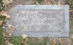
Fred Cecil Goman
| Birth | : | 30 Oct 1882 Viroqua, Vernon County, Wisconsin, USA |
| Death | : | 17 Feb 1945 USA |
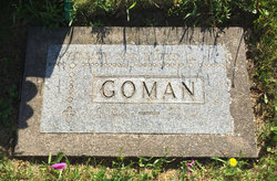
| Burial | : | Forest Lawn Memorial Park, Omaha, Douglas County, USA |
| Coordinate | : | 41.3272018, -95.9847031 |
| Plot | : | Segment# 7, Lot# 1203, Grave# 7 |
| Description | : | Son of Eugene and Sarah Goman. His father was born in New York and his mother was French Canadian. Fred Goman was married to Mable Edith Spanswick Anderson. He was stepfather to her sons Charles and Virgil. Fred and Mable's children were Eugene and Eva. Fred was a truck driver for more than 30 years in Omaha. Burial date February 20th, 1945. |
frequently asked questions (FAQ):
-
Where is Fred Cecil Goman's memorial?
Fred Cecil Goman's memorial is located at: Forest Lawn Memorial Park, Omaha, Douglas County, USA.
-
When did Fred Cecil Goman death?
Fred Cecil Goman death on 17 Feb 1945 in USA
-
Where are the coordinates of the Fred Cecil Goman's memorial?
Latitude: 41.3272018
Longitude: -95.9847031
Family Members:
Parent

Spouse
Siblings

Children
Flowers:


Nearby Cemetories:
1. Forest Lawn Memorial Park
Omaha, Douglas County, USA
Coordinate: 41.3272018, -95.9847031
2. Potter Field
Omaha, Douglas County, USA
Coordinate: 41.3320274, -95.9902878
3. Pleasant Hill Jewish Cemetery
Omaha, Douglas County, USA
Coordinate: 41.3185997, -95.9766998
4. Mormon Pioneer Cemetery
Omaha, Douglas County, USA
Coordinate: 41.3348450, -95.9663720
5. Golden Hill Cemetery
Omaha, Douglas County, USA
Coordinate: 41.3050003, -95.9744034
6. Springwell Cemetery
Omaha, Douglas County, USA
Coordinate: 41.3114014, -96.0096970
7. Mount Sinai Cemetery
Omaha, Douglas County, USA
Coordinate: 41.3116989, -96.0314026
8. Servants of Mary Cemetery
Omaha, Douglas County, USA
Coordinate: 41.3017170, -96.0258260
9. Mount Hope Cemetery
Omaha, Douglas County, USA
Coordinate: 41.3041992, -96.0310974
10. Prospect Hill Cemetery
Omaha, Douglas County, USA
Coordinate: 41.2780991, -95.9593964
11. Nash Chapel Crypt
Omaha, Douglas County, USA
Coordinate: 41.2665090, -95.9721790
12. Union Memorial Cemetery
Omaha, Douglas County, USA
Coordinate: 41.3512611, -96.0620193
13. Shipley Cemetery
Washington County, USA
Coordinate: 41.3932991, -95.9828033
14. First Central Congregational Columbarium
Omaha, Douglas County, USA
Coordinate: 41.2563456, -95.9658365
15. Holy Sepulchre Cemetery
Omaha, Douglas County, USA
Coordinate: 41.2543983, -95.9875031
16. All Saints Episcopal Church Columbarium
Omaha, Douglas County, USA
Coordinate: 41.2785000, -96.0579000
17. Trinity Cathedral Columbarium
Omaha, Douglas County, USA
Coordinate: 41.2603900, -95.9393660
18. Douglas County Poor Farm Cemetery
Omaha, Douglas County, USA
Coordinate: 41.2437240, -95.9723480
19. Bohemian Cemetery
Omaha, Douglas County, USA
Coordinate: 41.2388992, -95.9955978
20. Ak-Sar-Ben Racetrack Grounds
Omaha, Douglas County, USA
Coordinate: 41.2414703, -96.0159607
21. Saint Andrews Episcopal Church Columbarium
Omaha, Douglas County, USA
Coordinate: 41.2492500, -96.0427500
22. Countryside Community Church Columbarium
Omaha, Douglas County, USA
Coordinate: 41.2483660, -96.0500270
23. Westlawn-Hillcrest Memorial Park
Omaha, Douglas County, USA
Coordinate: 41.2346992, -95.9966965
24. Evergreen Memorial Park Cemetery
Omaha, Douglas County, USA
Coordinate: 41.2393990, -96.0355988