
| Birth | : | 7 Jul 1895 Beatrice, Gage County, Nebraska, USA |
| Death | : | 22 Jul 1980 Rancho Cordova, Sacramento County, California, USA |
| Burial | : | Camellia Memorial Lawn Cemetery, Sacramento, Sacramento County, USA |
| Coordinate | : | 38.5242004, -121.3097000 |
| Plot | : | Section A, Tier 13, Lot 85 |
| Inscription | : | US ARMY |
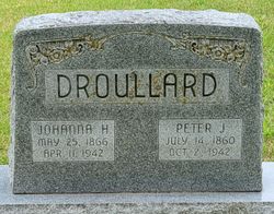
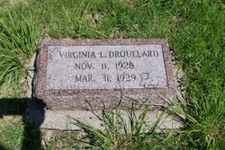
| Description | : | Son of Peter Jeremiah Droullard and Johanna Louise Hanke. Fred R. Droullard served in the 89th Division, 341st Machine Gun Battalion, U. S. Army during WWI. He served as a wagoner in the 177th Infantry Brigade. He served with the 341 MG Bn when it occupied Germany at the town of Bleialf. After his discharge in 1919, he returned to his home in Beatrice, NE. He married Grace Millicent Powell Mar 8, 1922 in Beatrice, Gage Co. NE. Father of: Robert Fredrick Droullard, Sr. Kenneth Devere Droullard Emerson Keith Droullard Virginia Lorraine Droullard 349 |
frequently asked questions (FAQ):
-
Where is Fred Robert Droullard's memorial?
Fred Robert Droullard's memorial is located at: Camellia Memorial Lawn Cemetery, Sacramento, Sacramento County, USA.
-
When did Fred Robert Droullard death?
Fred Robert Droullard death on 22 Jul 1980 in Rancho Cordova, Sacramento County, California, USA
-
Where are the coordinates of the Fred Robert Droullard's memorial?
Latitude: 38.5242004
Longitude: -121.3097000
Family Members:
Parent

Spouse

Siblings
Children
Flowers:


Nearby Cemetories:
1. Camellia Memorial Lawn Cemetery
Sacramento, Sacramento County, USA
Coordinate: 38.5242004, -121.3097000
2. Bellview Cemetery
Sacramento, Sacramento County, USA
Coordinate: 38.5153580, -121.3257446
3. Quiet Haven Memorial Park Cemetery
Sacramento, Sacramento County, USA
Coordinate: 38.5109711, -121.3245621
4. Greater Sacramento Muslim Cemetery
Sacramento, Sacramento County, USA
Coordinate: 38.5128300, -121.2616800
5. Sacramento Pet Cemetery
Sacramento, Sacramento County, USA
Coordinate: 38.4815870, -121.3402080
6. Chua Phuoc Thien Temple Columbarium
Sacramento, Sacramento County, USA
Coordinate: 38.4555400, -121.3345500
7. Kilgore Cemetery
Rancho Cordova, Sacramento County, USA
Coordinate: 38.5978012, -121.2683029
8. Tinh Xa Ngoc An Temple Columbarium
Sacramento, Sacramento County, USA
Coordinate: 38.5190200, -121.4159500
9. Elder Creek Cemetery
Florin, Sacramento County, USA
Coordinate: 38.5111008, -121.4169006
10. Union Cemetery
Sacramento County, USA
Coordinate: 38.4477997, -121.2619019
11. Saint Michaels Episcopal Church Columbarium
Carmichael, Sacramento County, USA
Coordinate: 38.6042800, -121.3547200
12. Sacramento County Cemetery
Sacramento County, USA
Coordinate: 38.5267900, -121.4233700
13. Sacramento County Veterans Memorial Cemetery
Sacramento, Sacramento County, USA
Coordinate: 38.5252838, -121.4239120
14. Sacramento County Hospital Cemetery
Sacramento, Sacramento County, USA
Coordinate: 38.5289300, -121.4239100
15. Russian Orthodox Cemetery
Sacramento, Sacramento County, USA
Coordinate: 38.5268800, -121.4244300
16. Saint Mary's Catholic Cemetery and Mausoleum
Sacramento, Sacramento County, USA
Coordinate: 38.5298900, -121.4261200
17. Pleasant Grove Cemetery
Elk Grove, Sacramento County, USA
Coordinate: 38.4302220, -121.3107670
18. Carmichael Presbyterian Church Columbarium
Carmichael, Sacramento County, USA
Coordinate: 38.6179500, -121.3324500
19. Sloughhouse Pioneer Cemetery
Sloughhouse, Sacramento County, USA
Coordinate: 38.4950130, -121.1916080
20. Saint Marks Methodist Church Memorial Tree
Sacramento, Sacramento County, USA
Coordinate: 38.6076500, -121.3750680
21. Kim Quang Temple Columbarium
Sacramento, Sacramento County, USA
Coordinate: 38.5996600, -121.3904700
22. Sacramento Memorial Lawn Cemetery
Sacramento, Sacramento County, USA
Coordinate: 38.5146484, -121.4380341
23. Home of Peace Cemetery
Sacramento, Sacramento County, USA
Coordinate: 38.5137558, -121.4382782
24. San Joaquin Cemetery
Sacramento, Sacramento County, USA
Coordinate: 38.4387665, -121.4034653