

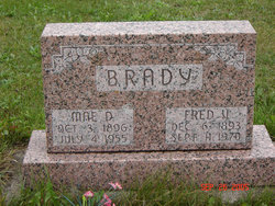
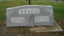
Fred VanCamp Brady
| Birth | : | 6 Dec 1893 Iowa, USA |
| Death | : | 11 Sep 1970 Branson, Taney County, Missouri, USA |
| Burial | : | Greenlawn Cemetery, East Crestline, Richland County, USA |
| Coordinate | : | 40.7850571, -82.7226782 |
| Description | : | Son of Milan James Brady & Reka Ann Kruger. He married Mae Dorcia Cree. |
frequently asked questions (FAQ):
-
Where is Fred VanCamp Brady's memorial?
Fred VanCamp Brady's memorial is located at: Greenlawn Cemetery, East Crestline, Richland County, USA.
-
When did Fred VanCamp Brady death?
Fred VanCamp Brady death on 11 Sep 1970 in Branson, Taney County, Missouri, USA
-
Where are the coordinates of the Fred VanCamp Brady's memorial?
Latitude: 40.7850571
Longitude: -82.7226782
Family Members:
Parent

Spouse
Siblings
Children

Flowers:


Nearby Cemetories:
1. Greenlawn Cemetery
East Crestline, Richland County, USA
Coordinate: 40.7850571, -82.7226782
2. Saint Joseph Cemetery
Sandusky Township, Richland County, USA
Coordinate: 40.7871600, -82.7215628
3. Barnes-Talbot Cemetery
Galion, Crawford County, USA
Coordinate: 40.7698000, -82.7592500
4. Riblet Cemetery
Springfield Township, Richland County, USA
Coordinate: 40.7612530, -82.6883880
5. Line Cemetery
Galion, Crawford County, USA
Coordinate: 40.7477120, -82.7357200
6. Leesville Cemetery
Crawford County, USA
Coordinate: 40.7942940, -82.7914940
7. Sacred Heart Cemetery
Shelby, Richland County, USA
Coordinate: 40.8384552, -82.7230606
8. Bitner Cemetery
Mansfield, Richland County, USA
Coordinate: 40.7367300, -82.6926810
9. Middletown Cemetery
Middletown, Crawford County, USA
Coordinate: 40.7701090, -82.7915850
10. Fairview Cemetery
Galion, Crawford County, USA
Coordinate: 40.7508908, -82.7793469
11. Gledhill Cemetery
Middletown, Crawford County, USA
Coordinate: 40.7751350, -82.7940420
12. Mount Calvary Catholic Cemetery
Galion, Crawford County, USA
Coordinate: 40.7498660, -82.7811778
13. Galion Mausoleum
Galion, Crawford County, USA
Coordinate: 40.7490980, -82.7810380
14. Red Squirrel Cemetery
Sandusky Township, Richland County, USA
Coordinate: 40.7319860, -82.6891760
15. Saint Paul Reformed Cemetery
Crawford County, USA
Coordinate: 40.8207880, -82.7859740
16. German Reform Cemetery
Shelby, Richland County, USA
Coordinate: 40.8349180, -82.6774410
17. Crawford County Memory Gardens
Crestline, Crawford County, USA
Coordinate: 40.8081128, -82.8037923
18. Dapper Cemetery
Crawford County, USA
Coordinate: 40.8278008, -82.7891998
19. Ontario Cemetery
Ontario, Richland County, USA
Coordinate: 40.7603127, -82.6404524
20. B'nai Jacob Cemetery
Ontario, Richland County, USA
Coordinate: 40.7606660, -82.6395680
21. New Castle Cemetery
Ontario, Richland County, USA
Coordinate: 40.7600250, -82.6360510
22. Union Green Cemetery
Galion, Crawford County, USA
Coordinate: 40.7359860, -82.7919280
23. Peace Lutheran Church Columbarium
Galion, Crawford County, USA
Coordinate: 40.7331469, -82.7897680
24. Pleasant Hill Cemetery
Springfield Township, Richland County, USA
Coordinate: 40.7408900, -82.6462900