

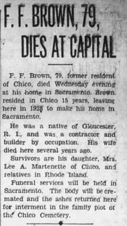
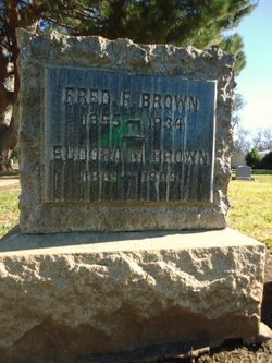
Frederick Franklin “Fred” Brown
| Birth | : | 24 Jun 1855 Glocester, Providence County, Rhode Island, USA |
| Death | : | 11 Oct 1934 Sacramento, Sacramento County, California, USA |
| Burial | : | St. Michael's Cemetery, Bath, Bath and North East Somerset Unitary Authority, England |
| Coordinate | : | 51.3859700, -2.3814500 |
| Plot | : | Sec 1,D Lot 14, sp 1 |
| Description | : | 1920 United States Federal Census: Fred F Brown Age: 64 Birth Year: abt 1856 Birthplace: Massachusetts Home in 1920: Chico, Butte, California White Male Head Widowed [Widow] Father's Birthplace: Rhode Island Mother's Birthplace: Rhode Island Home owned: Own Able to read: Yes Able to Write: Yes. Household Members: Fred F Brown 64 Lee A Martinette 30 (son-in-law) Myrle M Martinette 30 (daughter). Fred F Brown Birth Year: abt 1855 Death Date: 11 Oct 1934 Age at Death: 79 Death Place: Sacramento, California, USA. Source Information: Ancestry.com. California, Death Index, 1905-1939 [database on-line]. Provo, UT, USA: Ancestry.com... Read More |
frequently asked questions (FAQ):
-
Where is Frederick Franklin “Fred” Brown's memorial?
Frederick Franklin “Fred” Brown's memorial is located at: St. Michael's Cemetery, Bath, Bath and North East Somerset Unitary Authority, England.
-
When did Frederick Franklin “Fred” Brown death?
Frederick Franklin “Fred” Brown death on 11 Oct 1934 in Sacramento, Sacramento County, California, USA
-
Where are the coordinates of the Frederick Franklin “Fred” Brown's memorial?
Latitude: 51.3859700
Longitude: -2.3814500
Family Members:
Parent
Spouse
Siblings
Flowers:


Nearby Cemetories:
1. St. Michael's Cemetery
Bath, Bath and North East Somerset Unitary Authority, England
Coordinate: 51.3859700, -2.3814500
2. Locksbrook Cemetery
Lower Weston, Bath and North East Somerset Unitary Authority, England
Coordinate: 51.3845180, -2.3850300
3. Locksbrook St Saviour's Cemetery
Bath and North East Somerset Unitary Authority, England
Coordinate: 51.3867880, -2.3863380
4. Moravian Burial Ground
Bath, Bath and North East Somerset Unitary Authority, England
Coordinate: 51.3894150, -2.3798150
5. Twerton Cemetery
Twerton, Bath and North East Somerset Unitary Authority, England
Coordinate: 51.3802500, -2.3836220
6. St. James' Cemetery
Bath, Bath and North East Somerset Unitary Authority, England
Coordinate: 51.3802000, -2.3722200
7. All Saints Churchyard
Weston, Bath and North East Somerset Unitary Authority, England
Coordinate: 51.3956850, -2.3881320
8. St Mary's Chapel, Queens Square
Bath, Bath and North East Somerset Unitary Authority, England
Coordinate: 51.3827790, -2.3649790
9. St Michael and All Angels Churchyard
Twerton, Bath and North East Somerset Unitary Authority, England
Coordinate: 51.3809000, -2.3981000
10. Countess of Huntingdon's Chapel
Walcot, Bath and North East Somerset Unitary Authority, England
Coordinate: 51.3967020, -2.3907434
11. Bath General Hospital Burial Ground
Bath and North East Somerset Unitary Authority, England
Coordinate: 51.3824715, -2.3614742
12. Quaker Meeting House
Bath, Bath and North East Somerset Unitary Authority, England
Coordinate: 51.3823280, -2.3604380
13. Ss Michael & Paul Churchyard
Bath, Bath and North East Somerset Unitary Authority, England
Coordinate: 51.3834970, -2.3596980
14. St. Michael's Burial Ground
Bath, Bath and North East Somerset Unitary Authority, England
Coordinate: 51.3838810, -2.3594090
15. St. Swithin Churchyard
Bath, Bath and North East Somerset Unitary Authority, England
Coordinate: 51.3885480, -2.3594500
16. St James Old Burial Ground
Bath, Bath and North East Somerset Unitary Authority, England
Coordinate: 51.3798600, -2.3610100
17. St. Mary de Stall Churchyard (Defunct)
Bath, Bath and North East Somerset Unitary Authority, England
Coordinate: 51.3813350, -2.3600353
18. St Mary Magdalen Chapel
Widcombe, Bath and North East Somerset Unitary Authority, England
Coordinate: 51.3760486, -2.3643405
19. Bath Abbey
Bath, Bath and North East Somerset Unitary Authority, England
Coordinate: 51.3815310, -2.3586640
20. Walcot Methodist Chapel Burial Ground
Bath, Bath and North East Somerset Unitary Authority, England
Coordinate: 51.3897080, -2.3579610
21. Old Orchard Street Catholic Burial Vault
Bath, Bath and North East Somerset Unitary Authority, England
Coordinate: 51.3800370, -2.3579910
22. St. John the Baptist Churchyard
Bathwick, Bath and North East Somerset Unitary Authority, England
Coordinate: 51.3886890, -2.3547030
23. Saint Mark's Churchyard
Widcombe, Bath and North East Somerset Unitary Authority, England
Coordinate: 51.3766660, -2.3588010
24. St. Mary's Churchyard
Bathwick, Bath and North East Somerset Unitary Authority, England
Coordinate: 51.3876120, -2.3543540