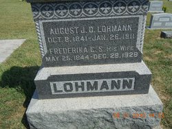
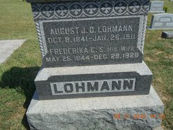
Frederika Caroline “Phoebe” Gropengieszer Lohmann
| Birth | : | 25 May 1844 Hanover, Region Hannover, Lower Saxony (Niedersachsen), Germany |
| Death | : | 29 Dec 1928 Easton, Leavenworth County, Kansas, USA |
| Burial | : | Saint Johns Lutheran Cemetery, Millwood, Leavenworth County, USA |
| Coordinate | : | 39.4042015, -95.1386032 |
frequently asked questions (FAQ):
-
Where is Frederika Caroline “Phoebe” Gropengieszer Lohmann's memorial?
Frederika Caroline “Phoebe” Gropengieszer Lohmann's memorial is located at: Saint Johns Lutheran Cemetery, Millwood, Leavenworth County, USA.
-
When did Frederika Caroline “Phoebe” Gropengieszer Lohmann death?
Frederika Caroline “Phoebe” Gropengieszer Lohmann death on 29 Dec 1928 in Easton, Leavenworth County, Kansas, USA
-
Where are the coordinates of the Frederika Caroline “Phoebe” Gropengieszer Lohmann's memorial?
Latitude: 39.4042015
Longitude: -95.1386032
Family Members:
Parent
Spouse
Siblings
Children
Flowers:
Nearby Cemetories:
1. Saint Johns Lutheran Cemetery
Millwood, Leavenworth County, USA
Coordinate: 39.4042015, -95.1386032
2. Evergreen Cemetery
Millwood, Leavenworth County, USA
Coordinate: 39.3833008, -95.1333008
3. Fairview Cemetery
Potter, Atchison County, USA
Coordinate: 39.4239006, -95.1613998
4. Oak Hill Cemetery
Millwood, Leavenworth County, USA
Coordinate: 39.3833008, -95.0943985
5. Langley Cemetery
Easton, Leavenworth County, USA
Coordinate: 39.3616982, -95.1611023
6. Old Young Cemetery
Potter, Atchison County, USA
Coordinate: 39.4480782, -95.1176071
7. Mount Pleasant Cemetery
Potter, Atchison County, USA
Coordinate: 39.4520187, -95.1412964
8. Round Prairie Cemetery
Lowemont, Leavenworth County, USA
Coordinate: 39.4122009, -95.0738983
9. Hays Cemetery
Oak Mills, Atchison County, USA
Coordinate: 39.4370300, -95.0883700
10. Springhill Cemetery
Potter, Atchison County, USA
Coordinate: 39.4303589, -95.2025375
11. Saint Lawrence Cemetery
Easton, Leavenworth County, USA
Coordinate: 39.3443985, -95.1335983
12. Easton Cemetery
Easton, Leavenworth County, USA
Coordinate: 39.3395882, -95.1237793
13. Saint Patrick Cemetery
Saint Pats, Atchison County, USA
Coordinate: 39.4689713, -95.1242523
14. Ashcraft Cemetery
Saint Pats, Atchison County, USA
Coordinate: 39.4695396, -95.1479034
15. Round Mound Cemetery
Cummings, Atchison County, USA
Coordinate: 39.4646988, -95.1908035
16. Mount Gillin Cemetery
Port Williams, Atchison County, USA
Coordinate: 39.4598618, -95.0670776
17. Corpus Christi Cemetery
Winchester, Jefferson County, USA
Coordinate: 39.3908005, -95.2394028
18. Pleasant Ridge Cemetery
Lowemont, Leavenworth County, USA
Coordinate: 39.3792000, -95.0344009
19. Sacks Family Cemetery
Oak Mills, Atchison County, USA
Coordinate: 39.4216800, -95.0316000
20. Stranger Creek Cemetery
Easton, Leavenworth County, USA
Coordinate: 39.3211100, -95.1016700
21. Mount Olivet Cemetery
Easton, Leavenworth County, USA
Coordinate: 39.3385010, -95.0582962
22. Hull Grove Cemetery
Winchester, Jefferson County, USA
Coordinate: 39.3630981, -95.2435989
23. Hightower and Cook Cemetery
Port Williams, Atchison County, USA
Coordinate: 39.4573100, -95.0421900
24. DeWeese Cemetery (Defunct)
Port Williams, Atchison County, USA
Coordinate: 39.4627500, -95.0473400

