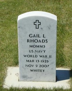
Gail Lewis “Whitey” Rhoads
| Birth | : | 13 Mar 1925 Anita, Cass County, Iowa, USA |
| Death | : | 9 Nov 2007 Miles City, Custer County, Montana, USA |
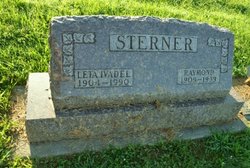
| Burial | : | Chocksett Burial Ground, Sterling, Worcester County, USA |
| Coordinate | : | 42.4377000, -71.7555400 |
| Plot | : | SECTION A SITE R10-3 |
| Inscription | : | US NAVY WORLS WAR II WHTEY |
| Description | : | Gail Lewis "Whitey" Rhoads, 82, of Miles City, died Friday, Nov. 9, 2007, at the Holy Rosary Extended Care in Miles City. Interment will follow in the Eastern Montana State Veteran's Cemetery. |
frequently asked questions (FAQ):
-
Where is Gail Lewis “Whitey” Rhoads's memorial?
Gail Lewis “Whitey” Rhoads's memorial is located at: Chocksett Burial Ground, Sterling, Worcester County, USA.
-
When did Gail Lewis “Whitey” Rhoads death?
Gail Lewis “Whitey” Rhoads death on 9 Nov 2007 in Miles City, Custer County, Montana, USA
-
Where are the coordinates of the Gail Lewis “Whitey” Rhoads's memorial?
Latitude: 42.4377000
Longitude: -71.7555400
Family Members:
Parent
Spouse
Flowers:
Nearby Cemetories:
1. Chocksett Burial Ground
Sterling, Worcester County, USA
Coordinate: 42.4377000, -71.7555400
2. Hillside Cemetery
Sterling, Worcester County, USA
Coordinate: 42.4410000, -71.7492570
3. Oak Hill Cemetery
Sterling, Worcester County, USA
Coordinate: 42.4417000, -71.7493973
4. West Cemetery
Sterling, Worcester County, USA
Coordinate: 42.4514100, -71.7651400
5. Fairbank Burial Ground
Sterling, Worcester County, USA
Coordinate: 42.4152600, -71.7320000
6. Cookshire Cemetery
Sterling, Worcester County, USA
Coordinate: 42.4108500, -71.7734800
7. Saint John's Cemetery
Lancaster, Worcester County, USA
Coordinate: 42.4328003, -71.6977997
8. Reservoir Pines Cemetery
Clinton, Worcester County, USA
Coordinate: 42.4084900, -71.7109700
9. Thayer Cemetery
Lancaster, Worcester County, USA
Coordinate: 42.4578500, -71.7024400
10. Legg Cemetery
Sterling, Worcester County, USA
Coordinate: 42.4070020, -71.7986150
11. Woodlawn Cemetery
Clinton, Worcester County, USA
Coordinate: 42.4185982, -71.6889038
12. Saint Lukes Cemetery
West Boylston, Worcester County, USA
Coordinate: 42.3833008, -71.7568970
13. High Plains Cemetery
West Boylston, Worcester County, USA
Coordinate: 42.3889008, -71.7972031
14. Middle Cemetery
Lancaster, Worcester County, USA
Coordinate: 42.4491997, -71.6757965
15. Parker II Cemetery
Princeton, Worcester County, USA
Coordinate: 42.4451900, -71.8370600
16. Old Settlers Burial Yard
Lancaster, Worcester County, USA
Coordinate: 42.4488754, -71.6742706
17. North Village Cemetery
Lancaster, Worcester County, USA
Coordinate: 42.4724998, -71.6778030
18. Old Common Burial Ground
Lancaster, Worcester County, USA
Coordinate: 42.4426700, -71.6645300
19. Beaman Cemetery
West Boylston, Worcester County, USA
Coordinate: 42.3649590, -71.7803600
20. Eastwood Cemetery
Lancaster, Worcester County, USA
Coordinate: 42.4417000, -71.6528015
21. Mount Vernon Cemetery
West Boylston, Worcester County, USA
Coordinate: 42.3634650, -71.7804030
22. Saint Leo Cemetery
Leominster, Worcester County, USA
Coordinate: 42.5153008, -71.7472000
23. Pine Grove Cemetery
Boylston, Worcester County, USA
Coordinate: 42.3582993, -71.7431030
24. Saint Cecilias Cemetery
Leominster, Worcester County, USA
Coordinate: 42.5166800, -71.7331900


