
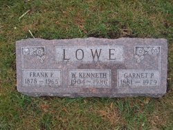
Garnet P. Walrod Lowe
| Birth | : | 28 Sep 1881 Clinton County, Iowa, USA |
| Death | : | 13 Oct 1979 Calhoun County, Iowa, USA |
| Burial | : | Greenfield Cemetery, Knierim, Calhoun County, USA |
| Coordinate | : | 42.4495000, -94.4565000 |
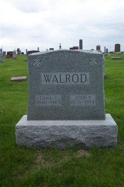
| Description | : | Wife of Frank P. Lowe Parents of W. Kenneth Lowe The 11 children of Michael Walrod, 1814, and Catherine Burger, 11. Garnet, bn Sept. 28, 1881, md in 1902 to Franklin P. Lowe, now deceased (sic). One son Walter Kenneth. Mrs. Lowe's present address is 22 Butler Building, Ft. Dodge, Iowa, where she now is a practicing Doctor of Chiropractic. SOURCE- One Branch of the Walrod Family Tree, W. Bruce Walrod, 1942 Iowa State Department of Health Division of Vital Statistics Delayed Certificate of Birth 00 206920 Garnet P. Walrod Date of birth: Sept. 28, 1881 Birthplace, Walton Twp., Clinton Co., Iowa Father: Michael Walrod, born New York Mother Maiden Name:... Read More |
frequently asked questions (FAQ):
-
Where is Garnet P. Walrod Lowe's memorial?
Garnet P. Walrod Lowe's memorial is located at: Greenfield Cemetery, Knierim, Calhoun County, USA.
-
When did Garnet P. Walrod Lowe death?
Garnet P. Walrod Lowe death on 13 Oct 1979 in Calhoun County, Iowa, USA
-
Where are the coordinates of the Garnet P. Walrod Lowe's memorial?
Latitude: 42.4495000
Longitude: -94.4565000
Family Members:
Parent

Spouse

Siblings
Children

Flowers:


Nearby Cemetories:
1. Greenfield Cemetery
Knierim, Calhoun County, USA
Coordinate: 42.4495000, -94.4565000
2. Trinity Cemetery
Calhoun County, USA
Coordinate: 42.4747200, -94.4555588
3. Calvary Presbyterian Cemetery
Barnum, Webster County, USA
Coordinate: 42.4742810, -94.3835020
4. Hope Cemetery
Manson, Calhoun County, USA
Coordinate: 42.4994011, -94.5199966
5. Fulton Lutheran Cemetery
Roelyn, Webster County, USA
Coordinate: 42.4263992, -94.3688965
6. Rose Hill Cemetery
Manson, Calhoun County, USA
Coordinate: 42.5228004, -94.5243988
7. Saint Josephs Cemetery
Barnum, Webster County, USA
Coordinate: 42.5172000, -94.3769000
8. Leith Cemetery
Manson, Calhoun County, USA
Coordinate: 42.4878006, -94.5667038
9. Mizpah Cemetery
Webster County, USA
Coordinate: 42.3835983, -94.3707962
10. Saint Thomas Cemetery
Manson, Calhoun County, USA
Coordinate: 42.5208500, -94.5365000
11. Roland Township Cemetery
Slifer, Webster County, USA
Coordinate: 42.3685989, -94.3685989
12. Cedar Cemetery
Rinard, Calhoun County, USA
Coordinate: 42.3456001, -94.4644012
13. Fulton Township Cemetery
Moorland, Webster County, USA
Coordinate: 42.4272000, -94.3159000
14. Logan Township Cemetery
Logan Township, Calhoun County, USA
Coordinate: 42.3539009, -94.5330963
15. Our Lady of Good Counsel Cemetery
Moorland, Webster County, USA
Coordinate: 42.4427986, -94.3043976
16. Reformatory Cemetery
Rockwell City, Calhoun County, USA
Coordinate: 42.3952570, -94.6038660
17. Saint Francis Cemetery
Rockwell City, Calhoun County, USA
Coordinate: 42.4055000, -94.6127000
18. Rosehill Cemetery
Rockwell City, Calhoun County, USA
Coordinate: 42.4042015, -94.6128006
19. Saint Paul Lutheran Cemetery
Pocahontas County, USA
Coordinate: 42.5610000, -94.5392000
20. Old Lizard Cemetery
Webster County, USA
Coordinate: 42.5249720, -94.3141340
21. Saint James Cemetery
Clare, Webster County, USA
Coordinate: 42.5691986, -94.3644028
22. Memorial Park Cemetery
Calhoun County, USA
Coordinate: 42.5189018, -94.6194000
23. Lizard Cemetery
Palmer, Pocahontas County, USA
Coordinate: 42.5875015, -94.4796982
24. Swedish Cemetery
Manson, Calhoun County, USA
Coordinate: 42.5426295, -94.5992013