
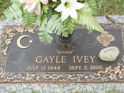
Gayle “Mama” Ivey Hughes
| Birth | : | 17 Jul 1944 Union County, South Carolina, USA |
| Death | : | 2 Sep 2000 Union County, South Carolina, USA |
| Burial | : | St. Bartholomew's Churchyard, Great Harwood, Hyndburn Borough, England |
| Coordinate | : | 53.7900670, -2.4055460 |
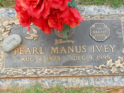
| Description | : | UNION - Gayle Ivey Hughes, 56, of 153 Oakland Road, died Sept. 2, 2000 in Wallace Thomson Hospital from injuries receive in an accident. Born in Union, she was the daughter of the late James Vernon Ivey, II and Pearl Manus Ivey. She was a Baptist and was formerly employed with Wellington Leisure Products Inc. Surviving are a daughter, Bobbie Gayle Bolling of Jonesville; two sons, James Scott West of Union and Mike Copeland Smith of Spartanburg; a sister, Paula Ivey Garner of Jonesville; four brothers, Maxwell Ivey of Texas, Terry Ivey of Union,... Read More |
frequently asked questions (FAQ):
-
Where is Gayle “Mama” Ivey Hughes's memorial?
Gayle “Mama” Ivey Hughes's memorial is located at: St. Bartholomew's Churchyard, Great Harwood, Hyndburn Borough, England.
-
When did Gayle “Mama” Ivey Hughes death?
Gayle “Mama” Ivey Hughes death on 2 Sep 2000 in Union County, South Carolina, USA
-
Where are the coordinates of the Gayle “Mama” Ivey Hughes's memorial?
Latitude: 53.7900670
Longitude: -2.4055460
Family Members:
Parent

Siblings
Flowers:


Nearby Cemetories:
1. St. Bartholomew's Churchyard
Great Harwood, Hyndburn Borough, England
Coordinate: 53.7900670, -2.4055460
2. Our Lady and Saint Hubert
Great Harwood, Hyndburn Borough, England
Coordinate: 53.7851070, -2.4009760
3. Great Harwood Cemetery
Great Harwood, Hyndburn Borough, England
Coordinate: 53.7796190, -2.4091680
4. All Saints Churchyard
Clayton-le-Moors, Hyndburn Borough, England
Coordinate: 53.7738520, -2.3881690
5. Barnes Square Weslyan Methodist Churchyard
Clayton-le-Moors, Hyndburn Borough, England
Coordinate: 53.7744350, -2.3853800
6. St Marys Burial Ground
Clayton-le-Moors, Hyndburn Borough, England
Coordinate: 53.7792778, -2.3705871
7. Church and Clayton-le-Moors Cemetery
Accrington, Hyndburn Borough, England
Coordinate: 53.7630200, -2.3804820
8. Saint Mary and All Saints Churchyard
Whalley, Ribble Valley Borough, England
Coordinate: 53.8211890, -2.4078080
9. St James Churchyard
Church, Hyndburn Borough, England
Coordinate: 53.7574640, -2.3942660
10. St. John's Churchyard
Read, Ribble Valley Borough, England
Coordinate: 53.8088800, -2.3585600
11. St James Church
Altham, Hyndburn Borough, England
Coordinate: 53.7928940, -2.3465250
12. St. Leonard Old Churchyard
Langho, Ribble Valley Borough, England
Coordinate: 53.8178590, -2.4552870
13. Whalley, Wiswell and Barrow Cemetery
Whalley, Ribble Valley Borough, England
Coordinate: 53.8308490, -2.4057280
14. Brockhall Hospital Cemetery
Brockhall Village, Ribble Valley Borough, England
Coordinate: 53.8186850, -2.4560220
15. Accrington Cemetery and Crematorium
Accrington, Hyndburn Borough, England
Coordinate: 53.7623787, -2.3508649
16. Queen Mary's Military Hospital Cemetery
Whalley, Ribble Valley Borough, England
Coordinate: 53.8337490, -2.4127930
17. Calderstones Hospital Cemetery
Whalley, Ribble Valley Borough, England
Coordinate: 53.8338710, -2.4147160
18. St. James' Parish Church
Accrington, Hyndburn Borough, England
Coordinate: 53.7519900, -2.3652600
19. Blackburn Cemetery
Blackburn, Blackburn with Darwen Unitary Authority, England
Coordinate: 53.7662430, -2.4726050
20. St Peter Churchyard
Salesbury, Ribble Valley Borough, England
Coordinate: 53.7915000, -2.4859100
21. Christ Church Churchyard
Accrington, Hyndburn Borough, England
Coordinate: 53.7478560, -2.3605820
22. St Leonard Churchyard Extension
Padiham, Burnley Borough, England
Coordinate: 53.7991800, -2.3222000
23. New Lane Baptist Chapel Chapelyard
Oswaldwistle, Hyndburn Borough, England
Coordinate: 53.7381100, -2.4049500
24. Wesleyan Methodist Chapel Chapelyard
Padiham, Burnley Borough, England
Coordinate: 53.8018980, -2.3181730