
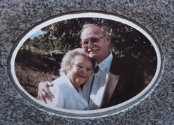
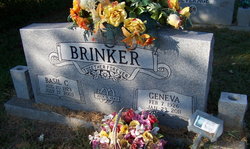

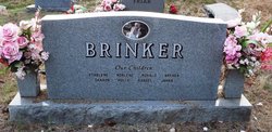

Geneva Ball Brinker
| Birth | : | 7 Feb 1926 Fremont, Carter County, Missouri, USA |
| Death | : | 23 Jan 2011 Russellville, Pope County, Arkansas, USA |
| Burial | : | IOOF Cemetery, Norman, Cleveland County, USA |
| Coordinate | : | 35.2439250, -97.4410950 |
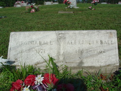
| Description | : | Geneva Brinker (February 7, 1926 - January 23, 2011) Geneva Brinker, 84, of Pottsville, died Sunday, January 23, 2011 at St. Mary's Regional Medical Center in Russellville. The daughter of Aaron Alexander and Virginia Ball, she was born February 7, 1926 in Fremont, MO. She was a member of the Christian Missionary Alliance Church of Russellville and a homemaker. She enjoyed taking care of her children and grandchildren, traveling, attending yard sales, working puzzles, playing card games and designing flower arrangements. She was preceded in death by her loving husband of 60 years, Basil Conrod Brinker; her parents; two brothers, James... Read More |
frequently asked questions (FAQ):
-
Where is Geneva Ball Brinker's memorial?
Geneva Ball Brinker's memorial is located at: IOOF Cemetery, Norman, Cleveland County, USA.
-
When did Geneva Ball Brinker death?
Geneva Ball Brinker death on 23 Jan 2011 in Russellville, Pope County, Arkansas, USA
-
Where are the coordinates of the Geneva Ball Brinker's memorial?
Latitude: 35.2439250
Longitude: -97.4410950
Family Members:
Parent

Spouse
Siblings

Children
Flowers:


Nearby Cemetories:
1. IOOF Cemetery
Norman, Cleveland County, USA
Coordinate: 35.2439250, -97.4410950
2. Saint Josephs Catholic Cemetery
Norman, Cleveland County, USA
Coordinate: 35.2450490, -97.4410990
3. Rock Creek Road Cemetery
Norman, Cleveland County, USA
Coordinate: 35.2464600, -97.4246140
4. First Christian Church Memorial Gardens
Norman, Cleveland County, USA
Coordinate: 35.2178000, -97.4460000
5. Saint John's Episcopal Church Columbarium
Norman, Cleveland County, USA
Coordinate: 35.2143160, -97.4426780
6. First Presbyterian Church Columbarium
Norman, Cleveland County, USA
Coordinate: 35.2126000, -97.4452000
7. Mex the Dog Burial Site
Norman, Cleveland County, USA
Coordinate: 35.2067000, -97.4422000
8. Saint Stephens UMC Columbarium
Norman, Cleveland County, USA
Coordinate: 35.2081000, -97.4684000
9. Lilac Hill Memorial Gardens
Moore, Cleveland County, USA
Coordinate: 35.2923560, -97.4557270
10. Warren Cemetery
Norman, Cleveland County, USA
Coordinate: 35.2402992, -97.5033035
11. Sunset Memorial Park
Norman, Cleveland County, USA
Coordinate: 35.2908310, -97.4079720
12. Saint Michael's Episcopal Church Columbarium
Norman, Cleveland County, USA
Coordinate: 35.1900000, -97.4667000
13. Saint Michael's Episcopal Church Memorial Garden
Norman, Cleveland County, USA
Coordinate: 35.1900000, -97.4667000
14. Smith Cemetery
Moore, Cleveland County, USA
Coordinate: 35.3055992, -97.4935989
15. Independence Cemetery
Norman, Cleveland County, USA
Coordinate: 35.1880989, -97.3696976
16. Fairview Cemetery
Norman, Cleveland County, USA
Coordinate: 35.3072410, -97.3708050
17. Adkins Cemetery
Goldsby, McClain County, USA
Coordinate: 35.1502991, -97.4518967
18. Ten Mile Flat Cemetery
Norman, Cleveland County, USA
Coordinate: 35.2804146, -97.5473099
19. Pet Memorial Gardens
Norman, Cleveland County, USA
Coordinate: 35.1813700, -97.5381200
20. Falls Cemetery
Denver, Cleveland County, USA
Coordinate: 35.2328670, -97.3179580
21. Moore Cemetery
Moore, Cleveland County, USA
Coordinate: 35.3328018, -97.5025024
22. Blackburn Cemetery
Norman, Cleveland County, USA
Coordinate: 35.2738991, -97.3171997
23. Newcastle Memorial Gardens
Newcastle, McClain County, USA
Coordinate: 35.2192800, -97.6004220
24. Denver Cemetery
Norman, Cleveland County, USA
Coordinate: 35.2097015, -97.2814026