

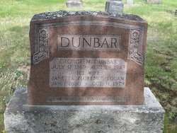
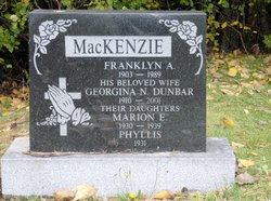
George Murray Dunbar
| Birth | : | 3 Jul 1868 Abercrombie, Pictou County, Nova Scotia, Canada |
| Death | : | 29 Aug 1943 Abercrombie, Pictou County, Nova Scotia, Canada |
| Burial | : | All Saints Churchyard, Tellisford, Mendip District, England |
| Coordinate | : | 51.2997270, -2.2877180 |
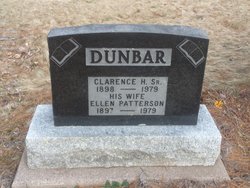
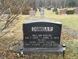
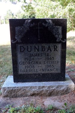
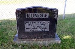
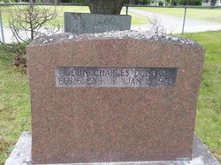
| Description | : | s/o William & Mary Ann (Murray) Dunbar; h/o Jeannette Florence Logan (m 1 Jun 1897 - New Glasgow, Pictou, NS), f/o Clarence, Dan, Bill, Jim, Ian, George, Marjorie, Irene, Jean, Mary, Georgina, John Charles 75y |
frequently asked questions (FAQ):
-
Where is George Murray Dunbar's memorial?
George Murray Dunbar's memorial is located at: All Saints Churchyard, Tellisford, Mendip District, England.
-
When did George Murray Dunbar death?
George Murray Dunbar death on 29 Aug 1943 in Abercrombie, Pictou County, Nova Scotia, Canada
-
Where are the coordinates of the George Murray Dunbar's memorial?
Latitude: 51.2997270
Longitude: -2.2877180
Family Members:
Parent

Spouse
Siblings


Children
Flowers:


Nearby Cemetories:
1. All Saints Churchyard
Tellisford, Mendip District, England
Coordinate: 51.2997270, -2.2877180
2. Christ Church Churchyard
Rode, Mendip District, England
Coordinate: 51.2861620, -2.2790890
3. St Leonard Churchyard
Farleigh Hungerford, Mendip District, England
Coordinate: 51.3155390, -2.2884820
4. St. Lawrence Churchyard
Woolverton, Mendip District, England
Coordinate: 51.2851540, -2.3021790
5. Farleigh Hungerford Castle
Farleigh Hungerford, Mendip District, England
Coordinate: 51.3173500, -2.2869590
6. St Lawrence Churchyard
Rode, Mendip District, England
Coordinate: 51.2792750, -2.2765370
7. Norton St. Philip Churchyard
Norton St Philip, Mendip District, England
Coordinate: 51.3001680, -2.3279700
8. St Mary's Churchyard
Laverton, Mendip District, England
Coordinate: 51.2757380, -2.3195910
9. St. John the Baptist Churchyard
Hinton Charterhouse, Bath and North East Somerset Unitary Authority, England
Coordinate: 51.3233330, -2.3219440
10. St George Churchyard
Beckington, Mendip District, England
Coordinate: 51.2635260, -2.2856810
11. All Saints Churchyard
Lullington, Mendip District, England
Coordinate: 51.2661940, -2.3121800
12. Beckington Baptist Chapel Burial Ground
Beckington, Mendip District, England
Coordinate: 51.2610760, -2.2897000
13. Freshford Cemetery
Freshford, Bath and North East Somerset Unitary Authority, England
Coordinate: 51.3379620, -2.3082970
14. Saint Peters Churchyard
Freshford, Bath and North East Somerset Unitary Authority, England
Coordinate: 51.3400570, -2.3033340
15. St Mary the Virgin Churchyard
Orchardleigh, Mendip District, England
Coordinate: 51.2576210, -2.3259440
16. Midford Burial Ground
Bath, Bath and North East Somerset Unitary Authority, England
Coordinate: 51.3394360, -2.3391424
17. Holy Trinity Churchyard
Bradford-on-Avon, Wiltshire Unitary Authority, England
Coordinate: 51.3465927, -2.2538147
18. Christ Church Churchyard
Bradford-on-Avon, Wiltshire Unitary Authority, England
Coordinate: 51.3507000, -2.2493360
19. Saint Michael & All Angels Churchyard
Buckland Dinham, Mendip District, England
Coordinate: 51.2600540, -2.3522580
20. St. Mary's Berkley
Berkley, Mendip District, England
Coordinate: 51.2435080, -2.2720990
21. Holt Cemetery
Bradford-on-Avon, Wiltshire Unitary Authority, England
Coordinate: 51.3468710, -2.2352160
22. St Julian's Churchyard
Wellow, Bath and North East Somerset Unitary Authority, England
Coordinate: 51.3240160, -2.3717630
23. Bradford on Avon Cemetery
Bradford-on-Avon, Wiltshire Unitary Authority, England
Coordinate: 51.3468700, -2.2336400
24. St. Michael's Churchyard
Monkton Combe, Bath and North East Somerset Unitary Authority, England
Coordinate: 51.3559540, -2.3285700